Category Archives: Spatial IT/GIS

Custom, Portable Maps — Via App!
Software company Avenza has evolved its map products into an app that lets people upload their own map—or download a map of their choice—to their mobile devices, and customize it. Whether for fighting a wildland fire, delivering packages, or exploring tourist sites, using a map should be easy and quick. Well, especially when you’re fighting...
Vertical Transformations and GIS
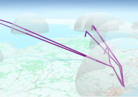
You know those moments where you are sitting in a pub, the office, or at a friend’s house and you say something, then suddenly wonder why you haven’t thought of it before? I had that very issue in the Brew Dog pub near Spitalfields in London, UK a couple of weeks ago. You see, I...
Map Making: “Can I have a map?”
“Can I have a map?” How often do you get someone ask, “Can I have a map”? I have nothing against making maps; in fact I like it so much that I have made a career out of it. Not just any map either, I’ve made maps for the nuclear, environmental, government, renewable energy, offshore...
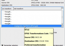
Using OSTN15 with QGIS
As you may be aware, the United Kingdom has a new transformation model that is OSTN15. But why? What does it mean to the geospatial community? Without being too nerdy, tectonic plate movement means that the “model” surface (the geoid) is slowly moving away from being the best fit for the coordinate system. It has...

Layla Gordon, Ordnance Survey Technology Laboratory Engineer
What is the Ordnance Survey Technology Laboratory? I managed to get an interview with one of the UK’s national mapping agency’s engineers, Layla Gordon, who has been working on some interesting geospatial tech. ND: How did your education lead you to OS (Ordnance Survey) and geospatial? LG: Back in 1994 I was doing a degree...
The Problem with QGIS and csv Files
Last month I was at the Maptime in Southampton (UK), helping QGIS new users with how to join tables and map EU referendum maps, when I came across an issue with something on QGIS I hadn’t spotted in the last *ahem* years of using it. When you drag and drop txt, csv, or other delimited...