Category Archives: Spatial IT/GIS
GIS without GIS (Using Spreadsheets)
No, I haven’t gone mad, though some might disagree. I was inspired to write this after talking to a colleague who previously worked for a bank they were tasked with getting proximities to properties using Excel alone. This got me thinking over how much we crank up the GIS, when sometimes it is so much...
Top 5 Things to Do When You Install a New GIS Software
So, you’ve just downloaded the new QGIS release, latest ArcGIS, or maybe you are completely new to GIS and wondering how to even get started with this behemoth eating up your (or your employer’s) disk space. Having done this MANY times over the last 15 years of working with geospatial software, I’ve noticed that there...

Mapping the Appalachian Trail, Part 2
How the AT was brought into GIS via a collaboration among ATC staff, NSP professionals, and dedicated volunteers. Part 1 of this article (May 2015) reveals the history of the trail, particularly how the land that comprises it was surveyed. Read here about how the trail was brought into GIS. In 1998, the Appalachian Trail...
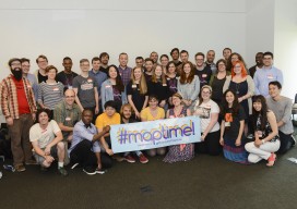
First Ever Maptime Summit
By Katie Kowalsky @katiekowalsky www.katiekowalsky.me It’s been over two years since the State of the Map US 2013, where Maptime was born. As of the first official Maptime in San Francisco at the time of the Maptime Summit (Monday June 8th), we now have 60 chapters spread over five continents. That growth, all from volunteers...
Dynamic Text with QGIS Layouts
It’s not until you need it that you realize how much you miss it: such is the case with the Esri ArcGIS dynamic text functionality. On the surface it seemed easy to put a little reference into a text box, and then every time I opened a template or new map it would automatically show...
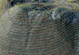
Comparing Maps a New Way
Above: The new standards are independent of map scale or contour interval and provide a way to deal with lidar data. ASPRS releases new positional accuracy standards. The positional accuracy of geospatial technologies has improved dramatically in the past few decades, and digital maps have replaced paper maps, making old ways of comparing maps obsolete. Satellite...