The Art of Retracement
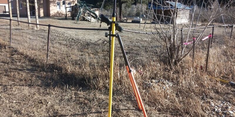
Pictured above: The rover stands on the original monument, which predates two newer monuments, next to each other 12 feet away, by 100 years. Credit: Warren Ward.
Igor Kidinski, or Eager (the Kid) as he was known, started to shout “Got it!” when he saw a point on the ground. But then he saw Glutton, also known as The Old Man (Glenny Dale), already looking at a different point.
The survey crew realized that, where they were trying to determine the location of one property corner, they had uncovered three monuments.
“According to this fairly new ALTA Survey, the exact deed location for this corner is the westernmost, newly set pin, and not the old pin this guy found about nine inches to the right,” reasoned The Kid, staring at the electronic plat on his tablet.
“Since two surveyors came very close to the same position, there must be solid justification for both surveyors to reject that old pin, which is 12 feet off. After all, all three pins originate from the same beginning point.”
“Hmm,” The Old Man grunted, respectfully. “But, this old pin here is where the original surveyor set it according to the 100-year-old deed. I’m guessing that Mr. Precision forgot that the purpose of an ALTA survey is to retrace the established ‘surveyed property.’ Instead he set a perfectly measured dimension from the 100-year-old deed right next to another almost perfectly measured number from the same deed.
“The legal objective was to retrace this 100-year-old pin, which was set in good faith by a surveyor following the old deed, 100 years ago, and make perfect measurements to it.”
At this spectacle, an owl made a loud “hoot!” from somewhere east, and both surveyors quickly looked up to be the first to spot it. The owl made three more “hoots!” to alert all the local wildlife of the approaching humans, but the crew couldn’t see it. They were straining their eyes on an old one-room schoolhouse and a newer, brick, four-room schoolhouse, now museum, on the neighboring lot.
Glutton considered himself a “ham historian.” The one-room cabin looked just like a General Land Office, and few people knew what that was. Often, when Glutton talked about history, Eager assumed that he was so old that he was actually there, watching it, as if he could connect today to anyone: say, John Brown or George Washington.
“How fitting that we have a pincushion right next to an old Land Office, schoolhouse, and museum!” pronounced the historian. “Surveying leads us here, just like it leads us throughout history.” The Kid listened carefully, not yet understanding.
“In 1748, George Washington started his surveying career. In 1755, British officer Braddock was defeated in a battle during the Seven Years’ War by the French with their allies, the Potawatomi Indians. Captain Washington survived this battle, and Potawatomi witnesses thought he was the Great Spirit that even four bullets couldn’t kill. Washington went on to help invent the system used to settle the West and started what was intended to be good faith ‘purchases’ of Indian Territory used for settlement.
“John Brown, the abolitionist, was a trained surveyor who used his skills to spy on pro-slavery groups in Kansas. There is a Land Office just like that,” pointing to the one-room log cabin, “in Potawatomi County, Kansas, where John Brown, along with the anti-slavery Potawatomi Rifles, lead the Potawatomi Creek Massacre of five pro-slavery citizens.
“The Potawatomi Indians were not indigenous to Kansas, even though they have a creek and county named after them. They were relocated by treaty from Michigan
to Kansas and Oklahoma, marched over what’s known as the Trail of Death,” The Old Man continued, still looking for that owl.
“The United States ‘resettled’ the Potawatomi several times, and in one treaty actually offered allotments. This meant that many Indians were given the choice to homestead allotments that the U.S. had ‘purchased’ from the Indians, just like all other settlers, on surveyed property, who prospered to this day as citizens.
“A few years later, near that same Land Office, a survey crew of five were found slain, scalped, and dismembered while laying out section lines for future settlers. Their compass and chain were found in a nearby Indian camp. The Plains Indians discovered too late that killing the survey crews, who usually looked harmless if not plain weird, would slow down the endless arrival of settlers.
“That old schoolhouse was placed on a school section based entirely on the basic freedom to purchase or homestead property, given to us as citizens, by surveyors who died for that idea. George Washington, through laws, gave us the political and legal means for surveyors like us to follow in the original surveyor’s footsteps.
“The men who passed these laws and the original surveyors who came out West—suffering the elements, terrain, wildlife, and Indian attacks to lay these properties out—were not too worried about slight imperfections in their measurements. By following in this old surveyor’s footsteps, we are upholding the very meaning of a free United States!” proclaimed The Old Man, proudly.
It was nearing the end of a sunny mountain day, and the shadows made the cottonwoods look disproportionately long. The hidden owl hooted out his enthusiastic agreement with The Old Man’s assessment, while The Kid set up the rover over the old monument, taking great care and pride—saluting with his right hand—to make an accurate measurement so that future surveyors could find this old, historical property corner.