Category Archives: Surveying
The DPPS Controversy
Why NALS should oppose the direct Point Positioning Survey (DPPS) policy outlined in the letter from NLM director Kornze to the governor of Alaska. (One Nevada surveyor’s opinion.) By Carl C. de Baca Some 86% of Nevada is comprised of Public Lands, and of that 60.8 million acres, according to the BLM’s own website, an...

Industry Innovation: Are You Ready to be Relevant?
Slay the beast named Apathy with progress. This is a dire warning. There is a beast that threatens to destroy the land surveying profession. It is a danger to you, your company, your coworkers, and your employees. It sucks the life from all it contacts. Its victims are left empty, with a sense of impending...

MAPPS, NSPS Announce 2017 National Surveying, Mapping & Geospatial Conference
Not your typical exhibit hall! TECH TIME SESSIONS Meet More People – Schedule Follow-up Discussions The 2017 MAPPS-NSPS National Surveying, Mapping & Geospatial Conference will feature “Tech Time”, a speed dating/speed mentoring concept which offers to those whose role is typically that of “exhibitor” the opportunity to be a “participant”, and to meet more people. Your...
Methods of Analyzing Data Part 3: Data Snooping & the tau Criterion
In previous articles, I discuss two rudimentary techniques that can be used to identify blunders in data. However, anyone who has used an advanced least squares adjustment package knows that such software often uses a post-adjustment statistic known as the tau criterion. The tau criterion is a modification of a method known as data snooping,...

Market Opportunities for Geospatial in 2017
Construction Prospects, Part One As we start a new year, it seems only fitting to take a look at what 2017 might hold in store for us. Let’s start with construction: a major source of income for the geospatial profession. Dodge Data & Analytics publishes all types of data for the North American commercial and...
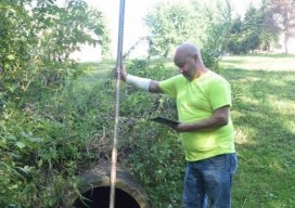
App Happy: Streaming Utility Surveys
A new app standardizes workflow by turning a list of surveyed points into underground 3D utility maps. Imagine that you’re surveying an underground waterline in your city. You use your survey devices to record the locations of the pipe system, including the manholes, the water valves, and their depths. Using your tablet on-site, you’re able...