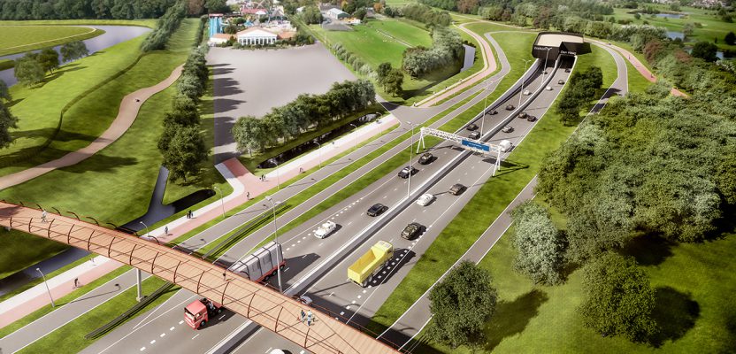
An artist’s rendering of the south entrance portal of the Rotterdamsebaan tunnels under construction. Credit: BAM Infra.
Monitoring Dutch tunnel construction under The Hague requires technology integration for tight tolerances.
To address congestion in densely populated cities, transportation engineers and city planners are increasingly turning to tunnels. An example is the Rotterdamsebaan tunnel currently under construction beneath The Hague (Den Haag) in the Netherlands. This complex project exemplifies a new era in urban tunnel construction. It is efficiently built, environmentally friendly, and designed to mitigate any impact on urban centers.
The Importance of Location
The Hague is the third-largest city in the Netherlands. Within its boundaries are some of Europe’s densest-populated metropolitan areas. It is home to federal agencies, royal residences, a busy harbor, and international bodies that include the International Court of Justice, the International Criminal Court, and major United Nations facilities. With so many stakeholders, independent monitoring of the Rotterdamsebaan tunnel’s impact was imperative.
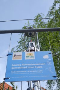
The Hague city council contracted Fugro to oversee the monitoring process. Fugro is an international provider of geospatial measurements and asset integrity data for large infrastructure construction and energy and natural resource management. Fugro would monitor the impact of the project on infrastructure along the tunneling corridor and would be responsible for surface deflection monitoring.
BAM Infra is also collaborating on the project. BAM is an infrastructure and tunneling construction firm and the main contractor for the Rotterdamsebaan project.
Understanding TBM
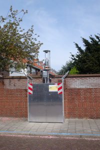
Monitoring robotic total stations were mounted on solid posts in secure enclosures along the route. These self-contained monitoring units have robotic total stations, communications radios/-modems, rain/snow hoods, and sometimes cameras. They operate as a connected network of instruments and common inter-visible monitoring/control points.
While modern tunnel boring machines (TBMs) are designed to minimize ground movement caused by the tunneling process, there will always be some ground reaction. The Rotterdamsebaan TBM, boring two parallel 11m-diameter tunnels successively, is operating at the relatively shallow depth of 20m to 30m below the surface. Despite this shallow traverse, the maximum allowed settlement detectable at the surface typically is only 12mm.
That the tunnels are constructed to meet such tight tolerances is a testament to meticulous design, advanced TBM technology, and skilled contractors. Such tight tolerances also put a premium on the instrumentation and skill of the monitoring teams.
Fugro applies best practices when monitoring such projects, which include using multiple robotic total stations arranged in networks in and around features to be monitored. These total stations are remotely controlled by monitoring software in cycles taking preprogrammed measurements with millimeter precision. Long- and short-term trends are easily identified based on these measurements, producing real-time results as the TBM passes under each segment of the tunnel corridor.
For its monitoring work, Fugro uses high-precision total stations like the 0.5-second Trimble S9. On a project of this magnitude, 40 or more total stations may be in use at any given time.
Fugro developed its own monitoring software, GeoRiskPortal, which has been used on a variety of projects worldwide. GeoRiskPortal connects to many types of monitoring instruments, including strain gauges and extensometers. Until this project, however, Fugro had connected GeoRiskPortal to just one brand of total station and wished to begin using Trimble total stations for automated monitoring, as well.
Because Fugro incurs a significant development cost to integrate instruments with GeoRiskPortal, the company contacted several manufacturers to work with them on the project. With the measurement performance of the S9, the support of the Trimble engineers, and the ability to efficiently integrate it into the GeoRiskPortal system, Trimble could provide a compelling solution.
Accurate Integration
In order to integrate the total stations with software such as GeoRiskPortal, an instrument needs to accept commands from the software and provide feedback and measurements (including metadata) without connectivity lapses or significant latency.
To meet these requirements, Fugro used the Trimble Precision SDK (TPSDK), a software development kit that supports multiple Trimble instruments, including the S Series total stations. The SDK enables software control of the instruments, allowing developers to pair these high-precision tools with their own custom software and instrumentation.
Monitoring the Tunnel
Richard Bun is the project manager and geodetic engineer for the project. His team set up four networks of monitoring instrumentation for the harbor, the tunnel exit area, and two residential districts. The exit area at the end of the tunnel in the center of The Hague was of particular concern as the TBM comes to the surface.
“We need to monitor the buildings immediately adjacent to the tunnel, certain additional buildings in the surrounding areas, and the ground surface,” he noted.
Bun explained that a control network of fixed reference marks is placed away from any movement caused by the tunneling. The total stations are situated throughout the corridor to have clear views of all building and surface features monitored for deflection.
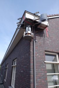
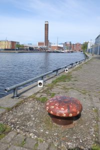
A concern in using total stations in developed or residential areas is noise. Typically, each total station is mounted on a small platform bolted to the sides of buildings or poles, under bridges, or positioned where they can capture a panoramic view from above the site. Sometimes the mounts are close to the windows of businesses or residences, and the noise generated by the frequent rotations of the total stations may be irritating to the occupant. This isn’t a problem with the Trimble S9 because it uses a magnetic drive to provide silent operation.
To connect the total stations into the reference networks, Bun placed target prisms on buildings and chimneys that can be seen by at least two total stations.
“We form networks that can be constantly measured and checked with the least squares adjustments,” he said.
With this self-monitoring reference network in place, the total stations can continuously take measurements while compensating for any movement.
“For soft ground or fields, we put an iron pipe in the ground that sticks up about one meter and has a prism on top. For hard surfaces like asphalt roads or concrete sidewalks, we can use the reflectorless mode of the total station. On buildings, we do two tiers of prisms, the first at about three meters and the second at about five meters.”

To monitor the “soft” areas of the tunnel corridor, iron rods with prisms were driven into the open fields/parks in dense arrays.
Based on these measurements, the GeoRiskPortal software can model any vertical, horizontal, or lateral movements of the surface or structures in real-time. When working in harmony, the robotic total stations are like “silent sentinels” keeping a watchful eye on any property and infrastructure above the tunneling, Bun said.
In the port areas above the tunnel route, arrays of monitoring prisms are measured by robotic total stations on an ongoing basis.
At the time of this writing, the TBM was nearly done with the first of the two parallel 1640-meter tunnels and preparing to begin the second parallel tunnel.
Bun noted that there was an initial investment to modify Fugro’s software to accommodate the Trimble S9, but the benefit of being able to this selection of instruments, especially on a project of this size, far outweighed the costs. Fugro has already expanded its capabilities on other monitoring projects and looks forward to continuing this momentum.