




Top Stories
Get your top stories below

GEO-MEASURE: Survey-Grade RTK Precision at a Consumer Price
Powering the next wave of accessible GNSS For decades, survey-grade GNSS rovers occupied the top tier of the market—tools of ...

Workflow Innovations at Trimble Dimensions 2025
How a user-driven rethink of field–office connectivity, training, and cross-industry collaboration is changing the way surveyors, geospatial teams, and builders ...

Jack Dangermond’s Vision for the Future
The geospatial industry is moving through a period of profound transformation. Advances in reality capture, artificial intelligence, and cloud integration ...
Topcon 2.0: Reclaiming the Geomatics Frontier
For decades, Topcon has been a trusted name in precision optics, GNSS receivers, and machine control. Its equipment became a ...
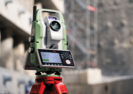
The Essential Instrument Gets Smarter
Just when you thought there was nothing new in the world of Total Stations… Image: Leica/Hexagon Appearances can be deceptive ...

Fixposition’s Vision-RTK Pro + Esri Is a Game Changer
The streets of modern cities are lined with glass and steel, forests close their canopy around remote infrastructure projects, and ...

xyHt Magazine September 2025
Read the September 2025 xyHt digital edition. Table of Contents GIS Needs Geodesy - Why accuracy matters more than ever ...
GIS Needs Geodesy
Why Accuracy Matters Now More Than Ever When I entered university to study geodesy in 1976, graduating students had begun ...

How Lidar Is Helping Cattle Farmers Make Smarter Land Use Decisions
In the rolling hills and rugged terrain of Spain, a quiet revolution is underway, one that’s helping cattle farmers make ...

Oriented Imagery in GIS: Unlocking Value From Unstructured Data
In an era defined by explosive data growth and rapidly expanding drone-based sensing, the geospatial community faces a new frontier: ...

GNSS Backup at the Atomic Level
A first-of-its-kind GNSS backup system provides independent navigation solutions using quantum magnetometry. This is a double-plus development. Not only is ...

The Woodstock of GIS: Inside the Esri UC 2025 Experience
At the San Diego Convention Center in July, thousands of GIS professionals, developers, and geospatial newcomers descended upon the 2025 ...
