A successful UAS project in North America tests the mettle of crew and craft as they gather high-resolution aerial imagery in both forested and swampy terrain, sandwiched between two active military facilities.
By John Stenmark, LS
Editor’s Note: Yes! Private surveying firms can use UAS on real projects (at least in Canada). We bring you the tale of a U.S. surveying firm that has taken the initiative to prepare for the coming UAS boom (when the rules eventually catch up to the tools) with some hands-on experience on a grueling project—with two models of UAS.
 Headquartered in Calgary, Alberta, Osum Oil Sands Corp. is one of Canada’s leading in-situ oil production companies. One of Osum’s efforts is the Taiga Project in the oil-rich Cold Lake area of northeast Alberta. Osum owns leases on 30 sections in the area and has started work to develop oil production there. With production slated to begin in a few years, Osum expects to produce 45,000 barrels per day when the development is operating at full capacity.
Throughout the development process, Osum has worked to minimize the project’s cost and environmental impacts. The Taiga project lies on roughly 2,600 acres (1,050 hectares) of public lands that have been used by aboriginal people for hundreds of years. Osum assigned Aboriginal relations coordinator Marie Robidoux to coordinate the gathering of accurate data representing the current state of the site. A Canada Lands surveyor, Robidoux needed maps and detailed information for planning and construction. While some earlier high-altitude lidar data exists, Robidoux wanted imagery with higher resolution.
In addition to planning for construction and production, Robidoux needed data for archeological and environmental assessments as well as for reclamation purposes. Once production has ended, Osum will remove all infrastructure and reclaim the site with the intent of putting it back to its original condition. “We wanted to capture information on the lease area prior to any activity,” Robidoux said. “It’s important to have detailed information on the pre-construction conditions. I had been reading about unmanned aerial systems [UAS] for mapping and was interested in using it for Taiga.”
As Osum was doing its initial planning, Paul DeGraff, vice president of International Operations for LW Survey Company (LWS), contacted Robidoux. Focusing on the energy industry, LWS operates crews in oil and gas regions throughout Canada and the United States. After discussing the project with DeGraff, Robidoux was convinced that UAS could provide the information she needed.
The companies agreed on a set of deliverables that included color orthophotos, a digital surface model (DSM), and infrared imagery. “The high-resolution photos will let me see what is on the site,” Robidoux explained. “The area has been used by aboriginal groups for centuries. The ortho imagery gives us bird’s-eye views and lets us see existing trails, for example, and try to preserve them if possible. We can use the near-infrared data to study existing vegetation and to make sure that the native trees and grasses are replaced during reclamation.”
 LWS assigned project manager Neil Robicheau to conduct the field operations. He would use two different UAS aircraft, a Gatewing X100 and the Trimble UX5 aerial imaging solution. In the field, both aircraft were controlled using the Trimble Yuma tablet. Robicheau would handle the office processing using the photogrammetry module in Trimble Business Center (TBC) software.
A Challenging Airspace
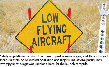
Neil Robicheau (we’ll call him and Marie Robidoux by their first names from here on) soon discovered that flying the project would have some unique aspects. To gain authorization for the flights, LWS worked with Transport Canada to obtain a Special Flight Operations Certificate (SFOC). The SFOC spelled out the times and dates, location, and purpose of the flights as well as the operator and type of aircraft. But there was more to do.
While the SFOC application was under review by Canadian federal authorities, Neil looked at the local challenges. The Taiga project area lies near Canadian Forces Base Cold Lake, operated by the Royal Canadian Air Force. A few miles to the north is the Cold Lake Air Weapons Range, which is used for live-fire exercises by the Canadian military and NATO forces. Neil needed special permission to fly the small unmanned aircraft in the airspace between the two installations, which comprised Canada’s largest air force base and its weapons training ground.
 “It took two days of phone calls,” he said. “Canadian Forces were very helpful. I coordinated with them to ensure we were not within restricted airspace, and that made it easy.” With the SFOC approval in hand, LWS was also required to issue a notice to airmen that they would be operating in the area. Finally, it was time to fly.
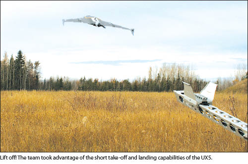
The Taiga site is covered with dense vegetation and boreal forest, which limited the selection of suitable sites for takeoff and landing. Neil selected five different locations from which the aircraft could cover the needed areas. A typical flight lasted 35 to 45 minutes, with the aircraft staying within 3,900 ft (1.2 km) of its takeoff site and control station. Canadian regulations limited him to flying at heights of 330 ft (100 m) above ground level. In order to capture the needed detail while flying at low levels, he needed to increase the overlap between images to 90%.
To gather data in the visible and near infrared spectra, Neil flew the project twice. The first flights used a Gate-wing X100 equipped to capture imagery in the near-infrared wavelengths. Data from those flights would supply information on the site’s vegetation. The second part of the mission used the Trimble UX5 aircraft to collect color photography for orthophotos and 3D surface models. In addition to gathering multi-spectral data, the operations allowed Neil to compare the performance of the two aircraft. “The X100 did everything we needed it to do” he says, but adds “the UX5 completely blew us away.”
 Using the UX5 controlled by the aerial imaging module for Trimble Access software, Neil conducted 18 flights in four and one-half days. He designed flights that were as long as possible and often pushed the electrically powered UX5 close to its maximum 50-minute flight duration. The aircraft made the work go quickly, needing only 10 minutes to download data from a flight and upload the next flight plan. Neil said that the short turnaround time between flights is an important aspect to the flight operations. After removing the aircraft battery and installing a freshly charged replacement, the aircraft was ready for its next flight.
In addition to the short turnaround time, Neil said that the ability of the UX5 to fly and land in confined areas provided needed flexibility in choosing takeoff and landing sites. “It felt like the UX5 could land on a dime,” he said. “When it comes down, it flies more of an arc, rather than just a straight slope. The reverse thrust and the body is incredible.” He estimated that the short turnaround time and improved flight characteristics of the Trimble UX5 reduced the time of the survey by roughly 45% over the X100. He also cited the larger, wide-angle image sensor, faster speed, and longer flight endurance as contributing to the increased performance.
The primary constraint was power for the aircraft. It takes roughly the same time to recharge a battery as to conduct a flight and—with only two batteries on hand— Neil would find himself waiting for a battery to finish charging before launching the next flight. He figured out that if he had more batteries it would be possible to fly pretty much continuously all day long. “The regulations restrict us to fly from an hour after sunrise to an hour before sunset,” he said. “At the equinox with 12 hours of daylight, I would say that you could easily get off eight or nine flights in a day.”
Because of the project’s low flight levels, large area, and need for precision, the work called forample ground control. Using a Trimble R10 GNSS receiver, LWS surveyors installed 46 control points over the 2,600 acres. They made the best of the terrain and dense vegetation, locating the control points in areas suitable for GNSS observations.
The team used single-base RTK to measure the points and double-checked them using the Can-Net VRS network operated by Cansel. The GNSS results were downloaded into TBC for access during photogrammetric processing. Although the terrain and tree cover dictated less than ideal geometry for the photogrammetry control, the GNSS points were sufficient for the adjustments and photo rectification in TBC software.
A Familiar Process
The process for planning and executing the UAS flights is similar to conventional manned aerial imaging. Once the overall objectives and location for the project were in place, Neil could use the Trimble Access aerial imaging module to plan the mission. The software can break the mission into multiple flights and create the individual flight plans. The flight plan is loaded into the onboard autopilot prior to each flight. After completing a pre-flight checklist, the aircraft is launched and automatically executes the flight, captures the imagery and lands at a designated location. To complete the cycle, the operator downloads the autopilot log and image data.
For the Taiga project, Neil broke the site into four mission areas with each covering roughly one section of land (640 acres or 260 hectares). The missions consisted of four to six flights. Each flight produced roughly 1,500 images, resulting in 11Gb of data per flight. Images for each section were combined into a single data set for processing by the TBC photogrammetry module.
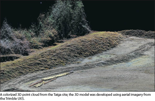
After running the initial routine to combine the images, Neil attached the photo stations to the GNSS control by identifying the ground control points visible in the imagery. This enabled him to produce the primary deliverable—georeferenced color orthophotos—as well as a 3D point cloud and colorized DSM.
The heavy vegetation provided challenges in producing ground elevations. “With the photogrammetry, you’re getting predominantly the tree tops,” Neil said. “By analyzing the photography and the point cloud, you could check the areas where there was an opening and you could definitely see spot elevations.”
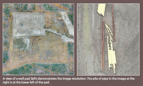
In checking the aerial data against ground truth points, he determined that the work was typically accurate to within 5 to 10 cm in three dimensions. When combined with the image resolution of 5 cm (2 inch) per pixel, the images provide exceptional clarity. “It’s much higher resolution than could be obtained from high-altitude flights,” Marie said. “At that resolution, you can see individual leaves on the ground.”
As the flying and processing progressed, both Neil Robicheau and Marie Robidoux noted the value of a good relationship with the system manufacturer—especially important with a new technology such as UAS. The work brought back much of Neil’s formal education in photogrammetry, but as he put it, “15 years is a long time to let your formal training sit idle.” By coordinating with technical experts from Trimble, he was able to develop strategies for managing and processing the huge datasets.
Marie was pleased with the operations and looks forward to putting the results to work. “It’s certainly cost-effective,” she said. “Without the UAS we would have had to use old data. That would require much more on-the-ground work for surveying and environmental information.” She added that because the UAS captures “everything,” it eliminates missing data as the cause for revisits by survey crews. “It’s very helpful in getting additional data, including information that you didn’t know you needed until after the field work was done.”
Neil likes the long-term potential of UAS. When combined with technologies such as mobile lidar, he thinks that aerial systems can dominate mapping applications. “The accuracy is there and it sure beats doing a whole topo with a survey crew,” he said. “There are so many applications. It seems like the way that the industry is going, people are trying to use UAS for everything.” He sees interesting applications in 4D monitoring in mining and large construction projects, where UAS can make frequent measurements to track volumes for production and pay quantities and track construction progress.
He pointed out that UAS offers safety advantages as well. When operating in mines or oil field environments, aerial mapping facilitates remote surveying and reduces the need for humans to enter congested or hazardous areas. He predicts that eventually conventional topographic techniques using GNSS or total stations will be reserved for infill to capture areas obscured from the aerial or vehicle-mounted sensors.
“We know it’s the future of mapping and we want to be at the front of the curve,” he said. “And as far as finding the application market for this, it’s just wide open. We’re going to continue to learn and we’re going to find ways to use it to save our clients time and money.”
John Stenmark, LS, is a writer and consultant working in the AEC and technical industries. He has more than 20 years of experience in applying advanced technology to surveying and related disciplines.
Sidebar
The Patch
As one of the world’s six largest oil-producing nations, Canada produces roughly 3.5 million barrels of oil each day. Much of Canada’s oil comes from the Athabasca oil sands formations in Alberta (referred to by some as “the Patch”), the third-largest proven crude oil reserve in the world. But extracting oil from sand is a difficult process that can produce considerable environmental impacts.
In many areas, oil sands are mined from enormous open pits and then processed to free the oil and bitumen. In recent years, however, a new technology has emerged for oil extraction. Steam-Assisted Gravity Drainage (SAGD) is an in-situ technique that uses a pair of parallel wells drilled horizontally into an oil sand formation, with one well lying a short distance below the other. The method injects steam into the upper well, heating the sand and allowing the oil to flow into the second, lower well. From there the oil can be pumped to the surface.
Because SAGD reduces the need for open-pit mining, it presents a more environmentally friendly approach to extracting the oil. SAGD produces oil from surface installations roughly the same size as conventional oil drilling and production pads, a footprint much smaller than strip mining. The method currently accounts for just over 50% of Alberta’s total production, and it’s expected that it will provide most of the future growth in production from the Canadian oil sands. Planning and executing that growth will call for some new approaches in gathering geospatial information.