An exceptional set of explorers surveys the caves inside a dying glacier on the side of Mt. Hood in Oregon.
All photos courtesy of Brent McGregor, except where noted.
Editor’s Note: High-profile scientific questions permeate the public consciousness, and surveying, mapping, and field data collection are the “ground truth” element of geophysical scientific research. This article presents a collaboration among scientists, mountaineers, and field data collection experts providing data to shed light on one of the most compelling scientific questions of our age.
Mountaineers climb mountains. Cavers explore caves. Surveyors measure and map. In Oregon, a small team of people with all three sets of skills and passions has been exploring caves under the Sandy Glacier, on the northwest side of Mt. Hood, two-thirds up the 11,250-foot mountain.
To assist them, they recruited glaciologists, geologists, and invertebrate collectors to provide scientific advice, as well as dozens of volunteer “sherpas” from the local mountaineering, mountain rescue, and caving communities to carry nearly 2,000 pounds of equipment 3,800 feet up the snow- and ice-covered mountain. The result, so far, is a set of maps, measurements, and photographs—many of them spectacular—that describe a dying glacier and document the glacier caves before these majestic natural structures are gone forever.
Why Glaciers Matter
Glaciers are changing with the planet’s warming climate. “Obviously, they’re receding, but our interest is how fast,” says Andrew Fountain, professor of geography and geology at Portland State University. “Are all of them changing the same way? If not, why not? How much of that water is contributing to sea level rise?”
“Scientifically,” Fountain explains, “these caves are important in that they form from running water: the snow-melt on the surface of the glacier makes its way through the ice and melts a little bit of it. If you have enough water draining at the same spot on the surface, then this passage of water melts out the glacier from the interior and develops a cave.” When the glaciers are thin, the ice doesn’t squeeze shut very quickly, so the cave can remain open and fill with air, which circulates and causes rapid melting at the base of the glacier.
 Water flowing through glaciers helps to control the movement of the ice as it slides down the side of the mountain. The rate at which a glacier slides depends on the amount of water pressure at its base. “It’s similar to air hockey,” says Fountain. “As long as those pucks have a lot of air pressure underneath them, they slide easily, but if you turn off the air they hardly slide at all. The caves, what we call conduits, help convey the water and partly control the pressure underneath the glaciers.”
This phenomenon has not been studied much because glacier caves are very dangerous. Glaciologists and climate scientists have tracked the melting of more than 200 glaciers around the world, almost always gathering their data from the surface. “This is not something that our traditional survey techniques can reveal,” Fountain points out. Satellite imagery, aerial photogrammetry and lidar scanning, and GPS units on the surface reveal only surface changes of the glacier. “But [the existence of these caves] means that things are happening underneath that can be really quite dramatic.”
The Sandy Glacier Caves
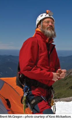
For years, Brent McGregor, a photographer, mountaineer, and woodworker, explored 17 glaciers in Oregon, rappelling into crevasses and photographing beautiful snow formations inside them, searching in vain for caves. Finally, in 2011, he came across a YouTube video of people inside a cave in the Sandy Glacier. He searched for it with Eduardo “Eddy” Cartaya, a U.S. Forest Service law enforcement officer, former military officer, search-and-rescue volunteer, and skilled rock- and ice-climber, and Scott Linn, a mountain rescuer and speleologist (scientific studier of caves).
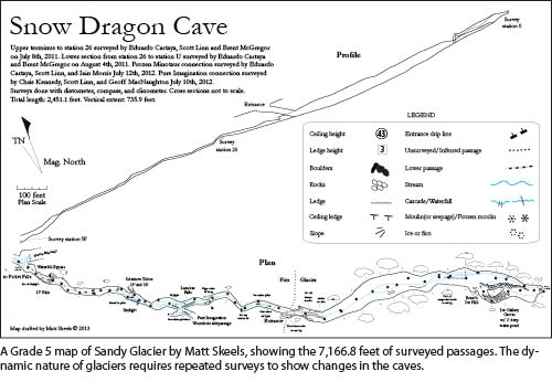
Over several trips in 2011 and 2012, they discovered a series of caves, as beautiful as they are impressive—which they named Snow Dragon, Pure Imagination, and Frozen Minotaur—and a moulin, a nearly vertical ice shaft from the surface of the glacier to the bedrock below. They have since explored and mapped about 7,000 feet of passages beneath the Sandy. “The biggest room is in Snow Dragon cave, and it is equal in record to the biggest lava tube room in Oregon,” says McGregor. “It is about 44 feet high and about 90 feet wide in a giant room that stays quite large for about 100 feet.”
 However, McGregor and Cartaya noticed that the caves were growing and suspected that it had to do with the air circulating through their openings. So, in the summer of 2012, having already surveyed most of Snow Dragon, they decided to organize a large expedition to survey the Pure Imagination and Frozen Minotaur caves and to collect rock, ice, soil, water, and seedling samples.
Cast of Characters
McGregor, who is in his 60s, and Cartaya, 44, draw on years of experience mountaineering and caving. However, when they asked Fountain to visit their camp, he was skeptical that they had found anything of significant scientific value and that their survey numbers would hold up to close scrutiny. “Then,” he recalls, “I get there and it’s like, ‘This is amazing!’ It’s unusual to have caves that big. They are scientifically interesting and aesthetically beautiful, fascinating.”
He was equally impressed with the two explorers and their surveying skills. “They are unique in that they were willing to go into these very tight spaces under real live water conditions. They’re doing a pretty precise job, and with some repeatability, so we had confidence in their numbers. That and their awareness of safety convinced me that they were doing a great job.”
 Cartaya’s surveying and mappingskills come from his military training. “I went to the U.S. Military Academy at West Point,” he says, “and took a lot of mapping courses that were designed for military applications: aerial photography, changing scales, a lot of land navigation, how to compute distances over canyons, using trigonometry, taking the angle measurements, and so on. To measure the roofs of the caves, you do the same thing. I also got an aerospace engineering degree there. Then, of course, I have been on many other cave surveys. You watch and you learn the process from experienced surveyors—how to set up a survey station and use the tools and do the sketching.”
McGregor and Cartaya’s team also includes one of Fountain’s graduate students, Gunnar Johnson, who studies the water chemistry of glaciers and microbes that live underneath the ice; Robert McGown, who collects samples of ash deposition layers in the glacier ice; Matt Skeels, a speleologist who has discovered and mapped many caves and is the team’s main cartographer; and Neil Marchington, a speleologist who is the project’s grant writer and leads the invertebrate collections. They also consult with Jason Gulley, a glaciologist at Michigan Technological University, who has explored glacial caves in Nepal, Alaska, and Norway.
Challenges
 Surveying glacier caves poses enormous challenges. First, McGregor and Cartaya needed to get all the required equipment to the base camp. “We were carrying 60 to 100 pound loads per person every time we went up the mountain,” says McGregor. “These weights made the approach, already technical and demanding, extremely arduous and mentally consumptive,” says Cartaya. The contents of their packs included wetsuits, ropes, crampons and ice axes, pickets, ice screws, survey gear, avalanche probes, vertical climbing gear, cave suits, camera and video equipment, freeze-dried dinners, oatmeal, cocoa, high energy bars, and even a 42-pound RV battery. “We needed 1,800 pounds of gear for our expedition, and Mount Hood Forest denied us the permit for a special use of a helicopter because it’s in a wilderness area and because they didn’t feel our mission required an air drop.”
“Therefore,” Cartaya continues, “we had to gather up a list of friends to help us. We had 50 volunteer ‘sherpas’ from Search & Rescue, from mountaineering clubs, from the caving clubs, each carrying 30 to 80 pounds of gear. Glacier caves are by nature dangerous, wet, cold, and a long ways from help, so we had to have a lot of supplies at our base camp. We had a medical station equal to what an ambulance would carry and medics in the camp. We had Search & Rescue people standing by.”
 Second, they had to deal with the very cold and wet environment, where even a minor injury could have left one of them dead from hypothermia. “We’re in water dropping down canyon-like features, setting picket anchors in the ice walls, and rappelling over waterfalls,” says McGregor. “So, we needed wetsuits and had to try to stay very warm, because the water temperature is 32.5 degrees.”
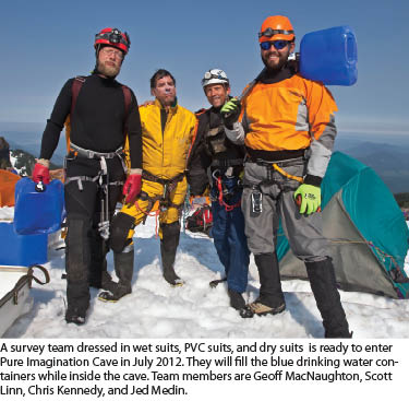
“Some of the surveyors wear dry suits, some wear wetsuits, and some just wear PVC cave suits, but those aren’t as good,” McGregor continues. “You’ve got to layer up underneath. Regular survey teams last about two and a half hours, and then their fingers get cold—especially the sketcher, to the point that he can’t sketch any more—so they come out of the cave. This was in July, when the sun was out and they could warm up for half an hour and then go back and survey some more later in the day. When Eddy and I survey, we’re a little more hardcore. We just suffer through it. We have extra gloves and whatever else we need.”
The wet conditions are also hard on the equipment. Halfway through one survey, the laser device got too wet and stopped working, so they had to stop. “Then we bought a better one,” McGregor recalls, “and cased it in a little Pelican box with a lanyard so that we could keep it up out of the water.”
The third challenge is the noise inside the caves. “The water is so loud that you’re shouting as loud as you can from station to station and it’s difficult to hear each other,” says McGregor. “So, you would yell the measurements to the person up at the next station, and he would yell them back to you to confirm that they were the same.”
The fourth challenge is the darkness. “The only natural light you’re going to have is when you’re by the cave entrance or beneath the skylights, but these caves have very few skylights,” says McGregor. “So, once you’re about two or three stations away from the entrance, you start to enter the dark zone. When you’re back in 500 feet, you see nothing. It is pitch black. We all have caving helmets that have really good caving lights on them. Cavers are used to doing everything in the dark, so providing the light we need is part of the survey.” Each new survey station is illuminated with a small light so that it can be seen from the previous one.
 Additionally, the wet environment often includes fog and spray zones in the caves. “There are parts of the caves where it’s very humid and there is a lot of water vapor in the air, so it’s challenging to see to the next station, sometimes,” McGregor says.
When surveying the moulin, additional dangers include rock fall and running water flowing down the inside of the giant pit during the day. At times, Cartaya and McGregor waited until late at night so that the lower temperatures would minimize the risks, then McGregor dangled in the middle of the pit to take the measurements, and still the streaming water drenched him.
Finally, some of the passages require crawling, “so you have to crawl, with all the survey tools and the sketch books, through these little water-filled passages,” says Cartaya. “You would go through some of these really difficult places with low ceilings and a lot of powerful water coming in, where you could barely get through,” says McGregor. “But struggling through one rough passage, where the water was making us both hypothermic, eventually led us to a large room of glacial ice: our first view of Frozen Minotaur Cave.”
Field Data Collection
Organizing the expedition, hauling their equipment up the mountain, rappelling down the moulin and across waterfalls, crawling through narrow passages… All that just got McGregor and Cartaya where they needed to be. Then, they surveyed. “We are making a three-dimensional map of all the cave systems,” Cartaya explains. “It’s cave surveying, so it’s a little different from land surveying.” At every station, they take five measurements: to the next station, to the left wall, to the right wall, up to the ceiling, and down to the floor.
Sometimes, McGregor and Cartaya are the only two on a survey team; other times they have four people helping. One person’s only job is to set up the next station, anywhere from 10 feet to 100 feet away from the previous one. “We don’t like to set up stations too far apart because we want to sketch in more detail between them,” says McGregor. They set up the stations “near significant features, such as a big pit or a hole in the ceiling or a water fall,” Cartaya points out.
McGregor likes to set up the stations, which is the easiest job, because it allows him three or four minutes to photograph before he has to set up the next one. “I always take a photo back at the station I just came from. Sometimes, those photographs help the mapmaker visualize the shape of the cave.”
To measure distances, they use a Bosch GLR 500 laser distance measurer, laid on or against the actual survey station, which could be a boulder or an outcrop of rock. They repeat each measurement three times for accuracy and enter it into a notebook, together with a quick sketch. “We put a little rock cairn and some ribbon and write the number of the station on the ribbon,” McGregor says, “and we can use those for the next survey, six months later, a year later, unless they’ve been knocked down from melt water, falling ice, or some other reason. Many of the stations have remained for over two and a half years now.”
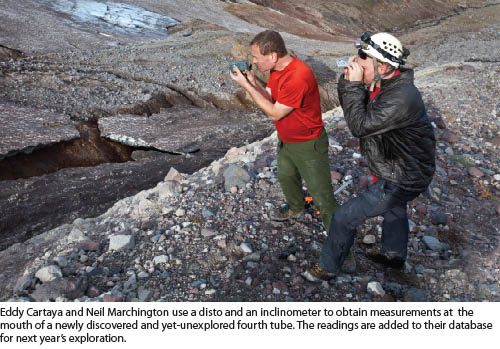
They use a Brunton survey compass to record the azimuth of the survey line from magnetic north and a Brunton inclinometer to get the slope of the floor. They measure all the angles to within a half degree and all the distances to within a tenth of a foot. They do not use a total station or even a standard pole because, in most cases, they would not fit through very difficult passageways.
One of the people on the team is the sketcher. “He’s recording all the figures and actually making a sketch of the shape of the cave,” says McGregor. “He’s sketching in any big boulders, any waterfalls coming out of the ceiling, or anything else of interest. We found a feather 1,800 feet inside the upper end of Snow Dragon Cave and marked its location because it was very unusual. We sent it to the Smithsonian Institute where it was identified as coming from a Mallard duck. It melted through the ice and had been there for probably hundreds of years.”
“If there is any significant side tunnel that dead-ends,” Cartaya says, “we’ll do what’s called a ‘splay shot’: we’ll shoot the laser down it, and take the compass heading, so that we can draw that into the map as a side feature.”
After each survey, they give all their data to their cartographer, Matt Skeels, who uses a freeware program called Compass to crunch the numbers and come up with a survey line. “While we are doing the surveying, we are also sketching in cross-sectional views,” Cartaya explains. “So, the final map will have a plan view, which is the bird’s eye view, a profile view, which is an ant farm view, and at interesting places along the cave it will have cross-sectional views, showing the shape of the passage as it appears when you are standing inside the cave.”
“Often,” Cartaya continues, “if a station is almost under water or it is so violent or cold that you can’t possibly sit there and sketch or take readings, we will do back readings. We’ll crawl through the passage, set up the survey station, then, when we get to the other side of it, we shoot back into it and take a back azimuth with the compass and a reverse sighting with the inclinometer. Of course, the laser measurement is the same.”
A key objective of each survey is to calculate the volume of ice that has melted each year. So, in order to survey a huge pit, they build a highline. “It is like a trolley line, over the top of the pit,” Cartaya explains. “Then we dangle a surveyor down a rope straight down the middle of it so that he can take cross-sectional laser readings.”
Findings
The moulin’s opening has widened by 36 feet in two years, and, according to Cartaya, its volume has increased by 400% in just one year. In some places, the Snow Dragon cave is 10 feet wider than it was a year ago. This expedition was the first to record this loss of ice. According to Fountain, the Sandy Glacier has retreated by at least 40% over the last 100 years, and his educated guess is that the ice used to be about 200-feet thicker. This survey’s findings reveal a glacier disintegrating from the inside out.
Surveying Challenge
Surveyors anywhere who have the skills and equipment to do it should consider surveying glacier caves, while they still exist. It would greatly help the scientific study of glaciers, add to their professional experience, and give them some great stories to tell!