2017 November xyHt Archives
Building a Solid Case: Forensic Mapping (and Ghost Clouds)
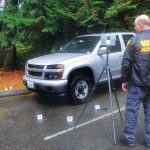
A Washington State Patrol officer improves the use of laser scanning for investigations by integrating field and office processes. Rod Green has been doing accident and crime scene reconstructions for 14 years. In addition to collecting and analyzing information, Green is working to improve the reconstruction process on-scene and in the office. His work is drawing […]
BLK360 + ReCap Pro: Collaboration for Reality Capture

Autodesk and Leica Geosystems collaborate on a highly anticipated scanning solution, the BLK360: practical, high-precision reality capture for everyone. We see so much written about 3D, BIM, and virtual and augmented worlds; it is easy to wax poetically about the potential for spatial analysis, automated feature recognition, space planning, and 3D design. There is much to […]
Finding Flat Spots: Better Weighing (WIM) for Better Trucking
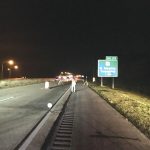
Laser scanning helps in building and troubleshooting weigh-in-motion stations for commercial trucks. With advances in automated traffic systems and improvements to traffic flows now common along many interstate highways, virtual weigh stations (also known as weigh-in-motion stations, or WIM) for commercial truck traffic are a logical development. This new type of station is an automated […]
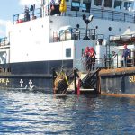
Recovering the Bouncing Bombs
Sidescan sonar helps a hydro survey team and a dive club find and raise the famous bouncing bombs from WWII. (Above: The SD Moorfowl lifts a Highball from Loch Striven.) As of May of 2018, it will be 75 years since the famous German dam buster raid by the Royal Air Force. The raid used […]