Tag Archives: lidar

xyHt Weekly News Recap: 06/28/2024
The Black Cape Scholarship for Women in Geospatial Intelligence EUSI Delivers SAR Imagery to DLR for Rapid Mapping of Southern Germany Floods Smart Cities Increase Drone Usage Worldwide Woolpert to Collect Aerial Lidar Data Across So. California for USGS Surveying Equipment Market size is set to grow by USD 2.72 billion from 2024-2028

Topobathymetric Lidar Tackles Great Lakes Coastal Mapping Project
The Great Lakes Restoration Initiative is an effort to protect and restore the largest system of fresh surface water in the world—the Great Lakes. As a part of this initiative, the National Oceanic and Atmospheric Administration (NOAA) has an ongoing effort to update all its bathymetric maps in the Great Lakes region, including advanced maps...
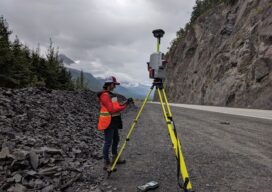
Pioneering for Tomorrow
The role of laser scanning in shaping our resiliency to natural hazards

Saving Alcatraz (Digitally)
The infamous island is under attack by climate change, rising sea levels, and old age. Can scanning it from the sky and on the ground preserve it? When the first functional photogrammetry uncrewed aviation vehicles (UAVs) became mainstream technology around 2013, geodesists and land surveyors around the world adopted these flying wonders as an innovative...
xyHt Weekly News Recap: 03/29/2024
Global Surveyor’s Day is March 21 Public Comments Sought on Draft ASPRS Positional Accuracy Standard Version 2.0 Commercial UAV Announces 2024 Advisory Board Woolpert Acquires Ireland-Based Murphy Geospatial, a Leading European Geospatial Firm Chung Hsing Brings Geospatial Data Acquisition to the Next Level in Taiwan Topcon Announces MC-Max Asphalt Paving and Milling Solutions Bilanciai Group...
Introducing Exyn Nexys –
A modular mapping and surveying ecosystem that allows users to quickly capture highly accurate, colorized, real-time 3D point clouds in complex, dangerous, or inhospitable environments like those in the mining, AEC, and geospatial industries.