October 2017 Archives
Organic Integration of UAS in the Pacific Northwest

A mapping and design firm in the Pacific Northwest implements UAS in diverse urban and rural environments. Editor’s Note: Integration (or not) of UAS by geospatial firms runs the gamut from outright dismissal of the technology, to firms taking a wait-and-see stance, to companies subcontracting out UAS services. Then there are those, like the mapping and […]
Wind, Water, and Fire: Hurricane Response in the Geospatial Community

Response, recovery, and rebuilding in the aftermath of hurricanes Harvey and Irma and the unprecedented wildfire season in the West may be the largest combined U.S. disaster response to date. The impacts to Texas, Florida, the broader Gulf Coast region, and many western states will require large national and international effort. We are all involved; […]
Unmanned Lidar in the Air
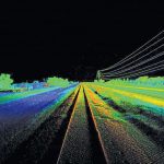
A discourse on UAV lidar from the perspectives of a vendor and a user. IS A UAV LIDAR SYSTEM REALISTIC? While UAV lidar is definitely a breakthrough for vendors and users alike, is it enough? Can UAV photogrammetry deliver what is really needed by the surveyor and engineer? Indeed it can, but only in part. […]
SWAMS

Using GIS for utility asset management: the Water Supply Asset Management System The cost of maintaining water system utilities is a concern of all responsible administrative authorities. And utilities are assets that need to be sustained rather than replaced again and again to provide people with quality service. Therefore, better asset management is needed; without […]
Equipment Theft

We’re battling surveying and mapping equipment theft in South Florida and we need your help. Data collection is the foundation from which maps are made, and a majority of this data has its origins in the field. Unfortunately, criminals repeatedly target the equipment used by surveyors and mappers due to the instruments’ value and relative […]
The Surprising HP Z2

A CAD designer reviews the HP Z2 workstation Editor’s note: Unless you’re looking in specific computer trade publications, you might not run across reviews of new PCs or workstations. The halcyon days of PC development in past decades and the battles for “bigger and more powerful” have given way to steady (but relentless) improvements. So, […]