September 2019 Archives
InSAR Quake “Rainbow”
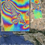
This graphic, which some folks call a rippling rainbow effect, is part of the valuable post-quake analysis of the 6.4 and 7.1 magnitude earthquakes—and thousands of minor quakes—in the vicinity of Ridgecrest, California in early July 2019. This map—produced by the Advanced Rapid Imaging and Analysis (ARIA) team at NASA’s Jet Propulsion Laboratory in Pasadena, […]
Construction Verification Automation

How multiple companies collaborated to solve persistent challenges to rapid comparisons of design models and constructed features—in high-precision 3D. Image above: the GTL-1000 scanner. When you look at the images in this article, if you see a piece of hardware and think this is a product review, you may be disappointed. It is an impressive-looking […]