xyHt in print November 2014 Archives
Satellite Signals Steer Farmers Straight

Precision agriculture combines GPS, remote sensing, and GIS to capture large amounts of georeferenced data on spatial variations in soil types, moisture content, nutrient availability, and crop yields and then create and follow prescription maps. Until recently, it was difficult for growers to correlate soil and crop information with production techniques, so they generally treated […]
CGVD2013, Part 2
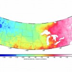
Above picture: This color contour map shows the difference between CGVD2013 and NAVD 88, especially of interest to those who work on projects along the U.S./Canada border. In part 1 of this series in xyHt’s October issue, Canada’s new vertical datum is introduced—CGVD2013— with an overview of past Canadian datums, directions during the current transition […]
The Hayden Example
Igor Kidinsky—known on this survey crew as Eager (The Kid)—carried the shovel and pick. Glenny Dale—known as Glutton (The Old Man)—carried the plans and metal detector. They had been looking for block corners and had found a mixture of old and new pins. Now they were looking for interior lot corners and came upon a […]