Tag Archives: geodesy
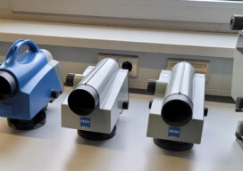
The Enduring Technology of Digital Levels – Part One
For nearly three decades, the foundational technology and design of precision levels for surveying has not changed much. It has not had to. Sometimes, when something is done right the best course is to stick with it.

Alex Hill-Stosky
24 Young Geospatial Professionals to Watch in 2024 Company: Eagle Engineering & ConsultingCurrent position: Manager of reality capture development and regulationAge: 38Education: BS in geodesy and geomatics engineering with cadastral survey option, University of New Brunswick; Diploma in geomatics engineering technology, Centre of Geographic Sciences Hill-Stosky was inspired by his brother to enroll at COGS...
Nejc Dougan
24 Young Geospatial Professionals to Watch in 2024 Company: FlaiCurrent position: Founder and CTOAge: 33 Education: BS, and MS in geodesy and geomatics, PhD student, University of Ljubljana Nejc Dougan stands at the forefront of the evolving geospatial landscape, merging the precision of geodesy with cutting-edge advancements in artificial intelligence. An alumnus of the University...

New Digital World Needs Data
Next-generation surveyors require specialized education and training to fill the role of geospatial data specialists. Many emerging geospatial applications, such as digital twins, 3D modeling, monitoring, virtual reality, and autonomous vehicles, are based on big digital datasets. Building a 3D digital world starts with accurate data that ties to a point on the ground, so...

Refining Measurement
A land surveyor unpacks the concept of accuracy “Accuracy is addictive,” my friend David Doyle once said. Doyle is a geodesist by trade. For someone in his line of work, this addiction has a rich tradition. Geodesy is the study of Earth’s shape, rotation, and gravity field. The discipline involves an eternal quest to refine...

xyHt Weekly News Links: 10/16/2020
How UAVs Make a Difference in Modern ForestryNew Topcon Robotic Total StationEarth Define Maps U.S. TreesNASA to Study Trees Impact on Remote SensingHxGN Content Program delivers airborne DSM to the Federal Agency for Cartography and Geodesy (BKG)Ronda Schrenk to Serve as USGIF Foundation CEO