Tag Archives: 3DR
Seen at HxGN LIVE 2019
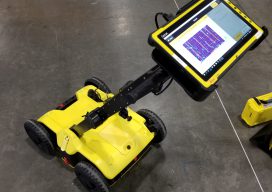
BLK2GO SLAM (simultaneous localization and mapping) lidar handhelds have become popular for BIM, as-builts, and rapid 3D modeling. The new Leica Geosystems BLK2GO shares some of the core technologies of earlier members of the BLK family (like the BLK360 scanner). What distinguishes this from many of the other SLAM handhelds is that it utilizes cameras...

Aerial Data Collection: Little Drone Takes on Big Airport
In a first-of-its-kind project, a UAS is tasked to collect aerial data of an international airport. By Jeff Salmon Normally when you add the words “drone” and “airport” to a sentence, it classifies as cringe-inducing. Just the opposite is true with this ground-breaking UAS project. The Hartsfield-Jackson Atlanta International Airport in Atlanta, Georgia, usually abbreviated...

xyHt News Links: 12/16/16
SolidCAD partners with leading aerial analytics company, 3DR! LizardTech Unveils Lossless Compression of Harris Geiger-Mode LiDAR Data in GeoExpress 9.5.3 Topcon announces distribution with Intel for both fixed- and rotary-wing UAS solutions
xyHt News Links: 9/16/16
Septentrio Launches New GNSS Receiver for Time and Frequency transfer applications Leica Geosystems launches HDS University Teledyne Optech Press Release: Solutions for wide-area mapping and infrastructure/mine surveys at Geomatics Indaba 2016 Topcon announces enhancements to UAS packages Orbit GT and AAM Group, Australia, join forces to open new horizons in the Mobile Mapping Market Announcing...
xyHt News Links: 3/11/16
Trimble 4D Control Software Supports IBIS-FM Radar Device for Slope Stability and Structural Monitoring in Mining TerraGo Launches On-Demand Solution for Mobile Forms, Inspections and Surveys Topcon announces new geodetic antenna Maptek modelling and exploration technology on show at PDAC Teledyne Optech Press Release: Innovative solutions for bathymetry at Oceanology International 2016 3DR collaborates with...