Tag Archives: ALTA
Tackling the Aerial-to-CAD Bottleneck
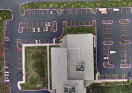
Aerial capture is getting easier and faster, but the subsequent step of CAD linework generation is a bottleneck—especially given the present shortage of qualified drafters. AI is stepping in to help. In 2017, the co-founders of what would become AirWorks Solutions Inc. first met and began discussing ideas for a new geospatial venture. Both had...
UAS and ALTA Surveys
Part 3 Precision, accuracy, and completeness are the end goals of UAS post processing, but how you get there to meet ALTA standards requires extra care. In Parts One and Two of this article in the September and October 2022 issues of xyHt we looked at the time/cost/precision proposition of using UAS for elements of...

UAS and ALTA Surveys – Part Two
Surveying firms that have been successful in incorporating UAS data in ALTA surveys adopt best practices to ensure precision standards are met. Plan, execute, and check. In Part One of this three-part series in the September xyHt issue, we looked at the time/cost/precision proposition of using UAS for elements of ALTA surveys. Firms interviewed agreed...

UAS and ALTA Surveys – Part One
Recognizing that with the right equipment and practices, specifications for ALTA surveys can easily be met, surveyors have rapidly adopted UAS for these and many other types of surveys. The adoption of UAS in the surveying profession has been more rapid than some past tech. It was only 2016 when the FAA Part 107...

2018 Commercial UAV Expo Roundup
I’ve said it before and I’ll say it again: attending the Commercial UAV Expo is the closest you’ll get to drinking out of a fire hose, data-stream-wise, without incurring physical damage. I’m talking metric tons of new and cool UAS stuff. This year I had the honor to be included as a judge in the...

The GeoDude on Scanning Efficiency
A Snapshot from the GeoDude on Rich Data Here’s a comparison of today’s field and office efficiencies—for conventional surveying methods versus laser scanning—as applied to topographic and site surveys. Above: The firm that used scanning for this site survey noted that more than 60% of these types of projects entail scope creep; scanning typically avoids go-backs....