Part 3
Precision, accuracy, and completeness are the end goals of UAS post processing, but how you get there to meet ALTA standards requires extra care.
In Parts One and Two of this article in the September and October 2022 issues of xyHt we looked at the time/cost/precision proposition of using UAS for elements of ALTA surveys, and best practices for field operations. In this installment we examine best practices for processing and feature extraction.
Packages
A drone platform is the unmanned aerial vehicle, or UAV. It is not until you add a sensor payload and other accessories for data capture, cameras, lidar, and gimbals, that it becomes an unmanned aerial system, or UAS. The UAV platforms, rotor or fixed wing, have become quite commoditized. And UAV that are sold for surveying and mapping applications, applicable mission planning and flight control software are often prescribed. Likewise for sensor payloads that make it a complete UAS system. There are recommended post-processing products as well.
Chances are that most firms with UAS programs went with the recommended and demonstrated software. By default, there are mandatory steps to get something from the raw images or scan data to a deliverable, and there are many options—good options—for software and/or cloud services. This is not Consumer Reports, and we’re not recommending or endorsing any products, so any mention of a product name is incidental.
Geo-location – GNSS/IMU
As we discussed in Part Two, a best practice for geo-location for UAS surveys, to meet ALTA relative positional precision requirements, is post-processed PPK/IMU and at least some ground control points. Unless you are doing specialized UAS work (e.g., indoors), the geo-location is done with GNSS data, almost always coupled with an integrated IMU. Integrated components like those from Applanix, NovAtel, and others, have become small enough to be practical for small UAS (sUAS).
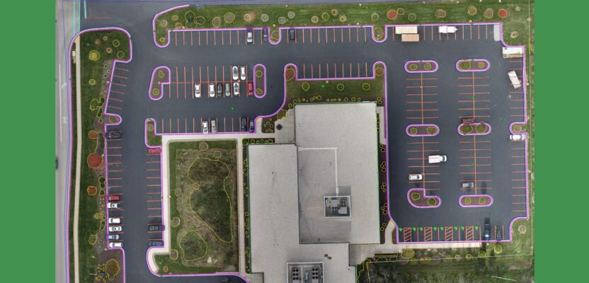
Example of an ALTA survey with 12 feature classes (plus topography) chosen by a customer for automated CAD extraction from an orthomosaic. Source: AirWorks
Commercially available UAV for surveying and mapping may have such components built in, and/or in certain payload packages. Geo-location post processing with software like Applanix POSPac, Klau PPK/PPP, and others do post-processed kinematic (PPK) after the flight, using observations from a base or network, along with the IMU data (if applicable). The solution is processed forward and then back (and some users do it forward again).
However, some folks are skipping this and going with RTK alone.
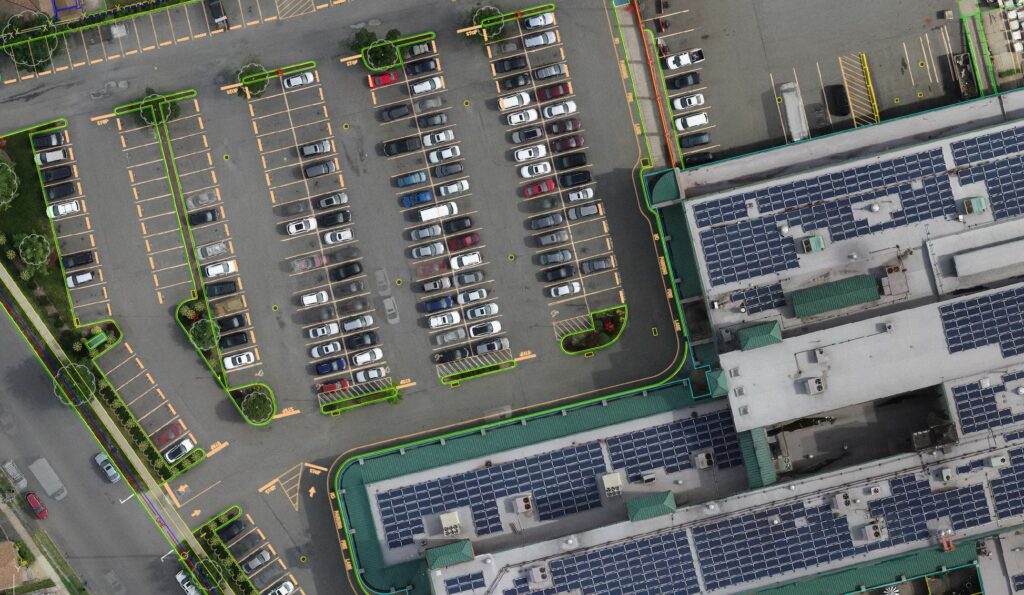
A properly executed UAS survey, with sufficient ground control, and post-processed positioning will yield a high precision orthomosaic and/or point cloud for heads-up or automated drafting. Source: Bowman
While RTK and PPK are essentially doing the same thing, with PPK you can wait for a more precise orbit data. RTK is limited to broadcast orbits, plus you can process the GNSS together with IMU data in more iterations. Network RTK can be handy, if the nearest physical base (PBS) is quite close, or if it is impractical to set up your own base, and you can also post-process with virtual-style Rinex. Additionally, like in the case of Klau PPK/PPP, precise point positioning (PPP) can be leveraged where there are no nearby bases. However a firm feels about going RTK or post-processed geo-location, for ALTA surveys, the latter seems to be standard. I did not find many surveyors who do ALTAs that eschew post-processed geo-location.
Photogrammetry
While aerial survey software packages can create an orthomosaic from images that only have a rough, autonomous GNSS position, and can match them up and create an orthomosaic, how well it fits the real-world benefits from high-precision positions up front. Numerous competing vendors offer standalone and online processing options.
“In the past, I felt that the quality was often poor and most of the cloud services had zero experience with the “real” work that goes into these projects,” says Derrick Westoby, UAS program lead at PBS Engineering and Environmental, based in Portland, Oregon. “But that’s not always the case nowadays, and there are actually some great cloud services with plenty of real-world experience now, like Propeller Aero, SiteScan, and Rock Robotic. I think right now, we’re probably at the point where either option makes sense for people. I’d guess that in the near future, it’s going to make more and more sense to use cloud services for this type of thing…especially for people with limited prior experience.”
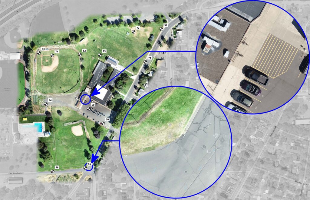
Flying at 150 feet, and with the array of ground control points shown. PBS was able to easily meet the ALTA relative precision requirements of 2cm+50ppm 2σ. Source: PBS
Some surveyors are not completely sold on online processing services for orthomosaics and point clouds. They prefer more direct control, leveraging their own experience in identifying quirks in the process. “With some software the proposition is basically: ‘Here’s your model.’ I don’t know how well they picked and resolved ground control points,” says Blair Ellison, UAV program manager at Weihe Engineers, of Indianapolis, Indiana. “If I’m running the software, and we like Agisoft for this, and I go into every photo that has the ground control points and I position by value on that ground control point myself, then it gives me a resolution I can count on.”
Ellison cautions about aberrations. “With a lot of UAS work you have to look for things like a ‘bowl’ effect across a wide flat area. This might not be noticed even when contours are being drawn. This is where GCP and checks are essential. Sometimes such glitches occur, and simply reprocessing usually fixes it…if you notice it.”
We keep getting back to the subject of GCP’s, that ALTA surveyors we contacted reiterate. As one put it: “You can skimp on the GCPs up front, and then have to do a lot of check shots only to find out it didn’t meet standards. Or do the extra work up front and improve your chances it will all fit.”
With the photogrammetry complete, a point cloud can be generated. In the case of lidar, nearly every manufacturer collects the shots in a proprietary format, optimized for rapid collection and large-data management. Though when processed into a point cloud, there are options to export to standard formats (e.g., E57, LAS, LAZ, etc.).
Classification and Cleanup
For whatever process the surveyor chooses to draft the linework for the ALTA from the point clouds, heads-up drafting or an automated service, there is almost always some cleanup and classification involved, like removing remnants and “ghosts” (e.g., vehicles or people passing through during the flight) and extracting a bare earth model by removing off-ground points like vegetation.
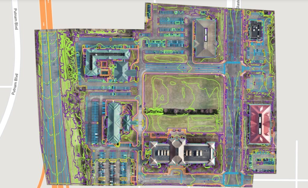
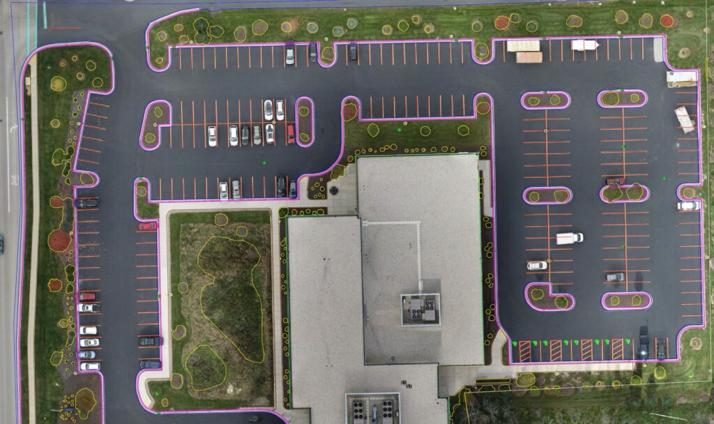
CAD linework automatically extracted from a UAS ALTA survey in Glastonbury Connecticut. It is estimated that for average site conditions, about 85 percent of the linework in desired feature classes is extracted. Source: AirWorks
Again, most UAS packages are sold with recommended software for classification and cleanup. Once you have a point cloud, this step for image-based and lidar point clouds is much the same. Though with lidar, you can have much more detail under canopy; especially with the advent of some newer UAS lidar systems like the Yellowscan Voyager that can have up to 15 returns per shot.
There are many good point cloud software packages, and everyone seems to develop a preference, depending on how deep they may wish to delve into the process. There are also popular online services for classification and cleanup. We did find that most of the surveyors we contacted that use UAS for ALTA surveys tend to want to be a bit more hands-on in the process.
Linework
There are many paths for extracting the linework needed for the ALTA: building locations, access points, evidence of use of the property by others, possible encroachments, fences, drives, utility features, water features, parking lots, parking spaces, etc. But not the boundary; you’re not going to do that with a drone. A skilled drafter can work from a point cloud, for instance, imported into CAD, to do heads-up drafting. However, present staffing challenges have made skilled drafters hard to come by, and especially hard to keep up with the flood of work survey firms are experiencing.
Increasing in popularity are online services for automated feature extraction from point clouds. While not completely automated, as there will still need to be some drafter intervention, services like AirWorks and others that can catch the majority of desired feature classes from a photogrammetry or lidar derived point clouds—depending on site conditions and quality of the UAS survey.
“We have found that with a service like AirWorks, it is difficult to compete with by hand,” says Ellison. “There’s probably a draftsman or two who can do it for the amount of time that they bill you for. But for overall comparative cost? Most of the time not, but if I add all of the optional feature classes, that are not optional for me, this adds up and it may become even money—however, that is not the whole value.”
When it comes to the cost of a draftsman versus an automated service, Ellison says that the key point is that automation becomes a force multiplier. “So, if it’s still even money, you’ve got skilled staff who are not tied up doing the whole thing; you can get more surveys drafted, you can take on more jobs.”
That point about automating the drafting, whether you choose to use such services or not, underscores a broader theme about the use of UAS for ALTA surveys, and other types of surveys: automate thoughtfully and carefully and you can increase productivity. After all, UAS became popular for surveying due to the simple proposition of increased productivity. And right now, there is a lot of pressure on the surveying profession to deliver a lot more, and much faster than ever before.