Tag Archives: CAD
The Vanishing Divide
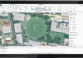
New solutions bridge the gap between CAD and GIS. Editor’s note: In our continuing examination of CAD-GIS integration we’ve presented several approaches and products. Internationally, a tremendous amount of work has been done towards integration, both in academia and in commercial software; here we introduce you to Graebert GmbH, German developer of popular CAD software...

The Extended Entity of Autodesk
Has Autodesk become too large? Too diverse? Did the software get too complex? Or are those concerns missing the point? We’re far from the day when we can think of something we’d like and it simply materializes: there’s still a long path between ideation and realization. But, for more than three decades the path between...
True 3D Design
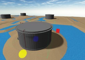
New geospatial software combines the appeal of games with the rigor of applications. It’s never been done before: applying the rigor and disciplines of civil engineering, mining engineering, hydrology, and even classic survey field-to-finish to game-like 3D design. Sure, CAD operators have had 3D viewing for years, which they use to review the results of...

25 Tips for BIM
Expert Recommendations for Better As-built BIMs Creating as-built building information models (BIMs) has been greatly facilitated by the introduction of 3D laser scanners and modeling software, but the process still has its challenges. Four experts were asked to put their decades of combined scanning and modeling experience into this list of the best tips, tactics,...