Tag Archives: CORS

The New Datum and Real-Time GNSS Networks
We asked U.S. RTN what their plans are for the upcoming changes to the National Spatial Reference System. When it comes to geodetic reference frameworks, “shift happens.” Surveyors (and others) have been through this before, like changes from NAD27 to NAD83, NGVD29 to NAVD88, from NAD83(CORS96) to NAD83(NSRS2007), and to the current NAD83(2011). Remember the...
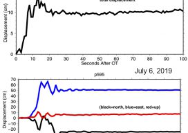
Shake, Rattle & Roll: Disruptions to the Geodetic Fabric
On July 4, 2019 the desert region near Ridegcrest, California was hit with a magnitude 6.4 earthquake, resulting in minor damage in the area, most significantly to the infrastructure at the Naval Air Weapons Station at China Lake. Approximately 44 hours later on July 6th, a larger earthquake of magnitude 7.1 struck the region, causing...
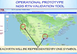
How Accurate Is an RTN?
Many surveyors have realized the benefits of using real-time GNSS networks (RTN) for survey-grade positioning. Saving time, equipment, and personnel means saving project costs. The thing about real-time GNSS surveying, however, is that “rover expertise” needs to be applied in the field (not the office). Additionally, many factors involved with GNSS signalization, as well as...

CORS Map
A First for Africa Geospatial professionals don’t need an introduction to CORS. For everyone else, it’s an acronym that stands for continuously operating reference systems: geodetic receivers that log GNSS observables continuously which, when transmitted to users with survey-grade receivers, help them achieve centimeter-accuracy measurements. CORS stations have a range of about 70 kilometers (~43...

xyHt News Links: 12/9/16
Topcon announces next generation of online support and training Septentrio announces seismic monitoring and advanced CORS features on PolaRx5 product line. Asteri Navigation launches X-series of wearable GNSS receivers
xyHt News Links: 9/9/16
FireFLY6 PRO Now Shipping! Sokkia introduces lighter and faster line of robotic total stations Septentrio’s Altus NR2 GNSS Receiver is Now Offered by Esri Satlab Geosolutions introduces SLX-1 Multi-application CORS GNSS Receiver [Webinar] The Latest Construction Site Land Surveying Practices Phase One Industrial Innovates Four Band Aerial Imaging Phase One Industrial Launches iXU-RS Aerial Camera...