Tag Archives: DELAIR
A Decade of Uncrewed Photogrammetry
Some might have had a peek at photogrammetry drones before 2013, but for me 2023 marks a decade since I first laid eyes on an uncrewed aircraft that “claimed” to do what I had been doing for years in bigger, more stable airplanes in the joyful company of pilots, copilots, camera operators, and navigators. In...
Rock, Paper, Drones
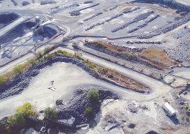
Above: Luck Stone flies one of their UAVs over their Bealeton quarry plant in Virginia. Luck Stone, a large mining and aggregates company, significantly improves their workflows and planning with UAVs and Delair’s UAV platform. In the mining and aggregates sector, half of your success is in the planning. Being prepared to have inventory available,...
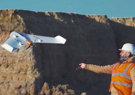
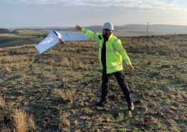
The Fixed-Wing Fix
Why a multi-discipline firm chose a fixed-wing sUAS solution for large-scale surveying and quantities for mines and quarries. Editor’s note: When xyHt began covering the rise of sUAS for AEC applications years ago, many of the early successful entries into the burgeoning sUAS market were fixed-wing craft, like those from Gatewing (that we wrote about...

Weekly xyHt News Links: 2/9/2018
Trimble Acquires e-Builder to Expand its Construction Management Solutions Orbit GT releases major update of 3D Mapping Cloud Teledyne Optech announces the new ALTM™ Galaxy PRIME: Higher point density increased range performance and superior cost reduction! Korea will launch its own satellite positioning system Trimble Introduces Next Generation GNSS Reference Receiver Delair offers advanced UAV for...
xyHt Weekly News Links: 9/29/17
Teledyne Optech and IGI announce new cooperative agreement and first product offering Hemisphere GNSS Debuts Next-Generation S321+ and C321+ GNSS Smart Antennas Septentrio unveils the new Altus NR3 at InterGEO GeoSLAM Launching Enhanced SLAM Software and Next Generation Mobile Scanner at InterGEO 2017 INTERGEO 2017 Berlin: Geo-IT-event officially opened Applanix Announces POSPac Cloud for Mobile Mapping...