Why a multi-discipline firm chose a fixed-wing sUAS solution for large-scale surveying and quantities for mines and quarries.
Editor’s note: When xyHt began covering the rise of sUAS for AEC applications years ago, many of the early successful entries into the burgeoning sUAS market were fixed-wing craft, like those from Gatewing (that we wrote about in Flight School and Yearning to Fly). Since, much of the press has been about rotor-based sUAS—that have become quite commoditized.
But fixed-wing solutions have continued to garner a substantial share of the market, for reasons exemplified in the following article. There are numerous applications where the fixed-wing sUAS are by far the best choice.
We’d also like to note that the sUAS solution provider in this story, Delair, includes elements of the legacy of the pioneering fixed-wing firm Gatewing (Trimble) as one of their strategic acquisitions in 2016.
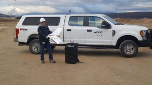
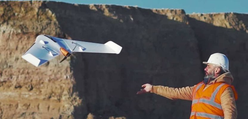
When Wood, a global leader in engineering services, first investigated using drones, they encountered barriers in the cost and the learning curve of the technology. For Wood, the Delair UX11 was the first drone that removed those barriers. With support from Delair, a leading supplier of commercial drone solutions, and Delair’s reseller partner, Frontier Precision, Wood recently implemented its first fixed-wing aerial data collection program.
“Where the technology and the costs are now, everything just fell into place,” says Greg Meinecke, technical services manager at Wood. “The UX11 was the right drone at the right time for us to get into the industry and make it work for us.”
Aerial and Terrestrial
Wood first used the UX11 in phosphate mines on the Wyoming-Idaho border. Downstream from the mines are huge disposal areas for the slurry material.
“For surveying the area, we tried standard GPS foot surveys in areas that were hundreds of acres,” said Meinecke. “We tried fast topo side by side, we tried different types of scanners, but none of it really worked. You have multiple pieces of big equipment moving and constant vibration, so ground methods aren’t a good option. It takes too much time and the weather changes, the light conditions change, and the results were never as accurate as we needed them to be. A fixed-wing drone like the UX11 was the only solution that made sense.”
The UX11 provided a solution to another challenge at the mines: quantifying material. As topsoil, overburden, and caprock are stripped, the amount of each material needs to be measured. The traditional measurement method of counting truckloads just wasn’t reliable or accurate.
“With the UX11, we can do a flyover, establish a ground model, do comparisons against previous ground models, and come up with quantities that are accurate for our sister company. The mine owners could look at the way we acquired the data and have confidence that they could buy off on it.”
The UX11 offers numerous benefits, including greater speed and accuracy of data gathering, and no lost productivity since there’s no need to shut down large equipment. With no people on the ground where large equipment is being used, it’s much safer as well.
Safety and Training
“At one site we worked on, we ran a continuous topo side by side out of a gator. I had a two-man crew out there for two days doing that, and it was only doable because it was a flat field. At one point the mining crew started excavating rock, which must be chiseled and blasted. They were working in a small area, but our guy couldn’t even walk through it. The mining crew said, ‘if you can’t fly it, you can’t go in there.’ So, we said, ‘I guess we need a drone.’ Now we can run out there, grab the data and be done in about four hours. With the savings in time, increased precision and safety, the UX11 is a whole new ball game.”
“If you can’t fly it, you can’t go in there.”
With any new technology, there’s always a learning curve. Nathan Stephenson from Frontier Precision helps clients master the hardware and software and use it accurately in a variety of different applications.
“Nathan was awesome,” Meinecke said. “He was instrumental to our success early on. He was always there answering questions and helping us understand what we needed to do.”
More Applications
Now that Wood has seen what the UX11 can do, Meinecke is looking forward to implementing it in other areas.
“If you get the bird in the air, it sells itself. It helped us push into more of the mining operations in places where you have to cover a lot of ground in a snapshot instead of taking days to survey it. We continue to use it in support of our large earth-moving sister companies, and we’ll push the drone into any sector where we can make it work. It has the potential for so many applications: fly a section of interstate they worked on, inventories, surveys, as constructed plans, aerial photos, pipeline corridors. We put the right cameras on that bird, and we can do leak detection, thermal sensing–the applications are endless, and we will be pushing the technology in new directions. Our teams are very intrigued about all the possibilities.”
The Team
Wood is a global leader in the delivery of project, engineering and technical services in energy, industry and the built environment.
Delair is a leading provider of drone-based solutions used by customers in industries such as utilities, construction, agriculture, transportation, mining, and oil and gas. The company is headquartered in Toulouse, France, and has offices in Ghent, Belgium; Los Angeles, and Singapore.
Frontier Precision is an employee-owned company with over 30 years of experience serving survey, mapping, engineering, construction, GIS, forensics, law enforcement, forestry, water resources, mosquito and vector control, and natural resources professionals. Frontier provides business solutions in the areas of UAS/Drones, laser-based scanning, 3-D visualization, and virtual reality. Headquartered in Bismarck, North Dakota with locations in South Dakota, Minnesota, Colorado, Montana, Idaho, Oregon, Washington, Alaska, and Hawaii.