Tag Archives: gps
2022 Monumental Changes, Part 2
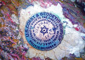
The U.S, National Geodetic Survey continues its examination of the impacts to passive geodetic control networks by the planned 2022 reference frame modernization. Editor’s note: A Field Notes article by Scott Martin posed the question, “Are HARNs on Death Row?” and Dru Smith began answering that in the December 29017 xyHt cover story. Here in...

Weekly xyHt News Links: 1/26/18
Teledyne Gavia has just announced the release of the iXblue Phins Compact C3 module for its Gavia Offshore Surveyor AUV Applanix Introduces its Autonomy Development Platform for Accelerating Research, Development, and Production of Autonomous Vehicles Topcon 2018 Technology Roadshow kicks off end-user training tour in multi-day stops across North America Topcon announces new manual total...
xyHt Weekly News Links: 8/11/17
TerraGo and Laser Technology Partner to Integrate Industry-Leading Rangefinders with Advanced Field Data Collection Apps GeoCue’s GNSS kit for drones provides survey-level accuracy Draper equips UAVs with vision for GPS-denied navigation 3D Robotics Joins Forces with DJI and Launches UAV Data Solution
xyHt Weekly News Recap: 5/19/17
Satlab Geosolutions introduces Ultra-Compact Multiconstellation GNSS UAV/RTK Receiver including Dual Antenna Heading capability senseFly Corridor solution boosts efficiency of linear mapping projects Icaros Releases Version 5.0 of OneButton™ Drone Image Processing Software Congress increases funding for UAS research, airspace integration Blue Marble Releases Mobile Friendly Version of the GeoCalc Geodetic Registry Swift, Carnegie release Duro for...
xyHt Weekly News Links: 04/28/17
Teledyne DALSA previews its versatile and advanced LWIR camera platform at AUVSI Juniper Systems releases the Mesa 2 Rugged Tablet with Android O INTERGEO 2017 | SMART CARTOGRAPHY : How old-fashioned navigation aids have been transformed into today’s smart maps Octopus ISR Systems Integrates VectorNav GPS/INS to Develop Precision Geo-Lock Feature for Epsilon Series Gimbals...
Weekly xyHt News Links: 4/7/17
Qinertia, a post-processing software to complete our offer for the surveying industry TCarta Marine to Introduce Gulf of Mexico Streaming Basemap Service and 2-Meter Bathymetric Data at Esri Petroleum Conference ClearEdge3D Releases VerityTM Construction Verification Software Tallysman introduces dual-band plus L-band GNSS antenna A look at NGS’ GPS on benchmarks program in Alaska Blue Marble Offers Free...