Tag Archives: lidar

xyHt Weekly News Recap: 09/08/2023
Space Flight Laboratory (SFL) Announces Performance Milestone for GHGSat Greenhouse Gas Monitoring Microsatellites Sony Electronics Launches Ultra-Lightweight, E-mount Interchangeable Lens Camera UP42 and ImageSat International Partner to Unlock Critical Applications of Geospatial Data Association for Royal Geographical Society Renew Collaboration Improving Efficiency and Reducing Damages to Underground Facilities Olivia Powell and EVONA trailblaze WGIC’s DEI...
xyHt Weekly News Recap: 07/07/23
TDI-Brooks Completes Shallow Water Geotechnical Coring Project Off Us East Coast FARO Technologies Appoints Peter Lau as President and Chief Executive Officer WGIC Welcomes Nominations for DEI Trailblazer Awards 2023 Topcon Acquired Finnish Industrial Radio Solutions Leader Satel Leica Introduces Hybrid Imaging and Lidar Sensor for Large-Area Mapping Experience the Trimble Community in Action in...
xyHt Weekly News Recap: 6/23/23
New Seafloor Mapping Program Supports Marine Safety and Planning in Two Indigenous Communities Alameh Selected as Inaugural Executive Director of Taylor Geospatial Institute LexisNexis Improves Insurer Risk Assessment Portfolio with National Tree Map SAM Companies Acquires AXIS GeoSpatial Leica Geosystems Introduces Hybrid Imaging and Lidar Sensor for Airborne Mapping GEO Business 2023 Receives Glowing Reviews ...
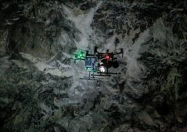
Autonomous Drone Mapping
How interior spaces like mines are being scanned and imaged by a drone that works without a pilot or connectivity. There is a scene in the Ridley Scott-directed 2012 sci-fi thriller “Prometheus” where a deep space exploration crew lands on a planet and discovers an underground labyrinth. They lob a levitating orb down a tunnel,...

The Advantages of “Built Here”
There are reasons other than policy and security to consider domestically produced drones. Yes, when it comes to the drone market there is an almost “default” choice. Having established dominance, it further benefits from price by volume. And then they can invest more in R&D from the increased profits—if they choose to and do not...
xyHt Magazine Heights 2023
Click on the cover to view the Heights 2023 supplement to xyHt magazine. Articles in the issue include: From Nadir to Oblique: From traditional airplanes to new-fangled gyroplanes, we take a look at several aspects of the aerial geospatial technologies that just keep getting better. The Future of Photogrammetry: While UAVs continue to emerge as aerial mapping vehicles, there...