Tag Archives: lidar

Reality Show Material
So when are they going to do a reality show about us scanner jockeys? The ship owner (I’ll call him Bill) flew me up to Alaska specifically for this project and told me not to worry about anything, that he would arrange for my food and boarding. Usually that means I’m put in a nice...
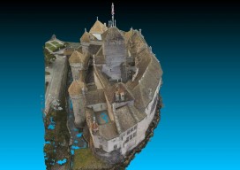
Chillon Castle: A Pix4D Sample Project
Above picture: Point cloud of full model of castle, shown from the top I wrote a review of Pix4D’s Mapper software in the November print issue of xyHt; check it out. Here’s Pix4D’s sample project to showcase the power of their software. They chose to create a model of Switzerland’s most visited site: the Chillon...
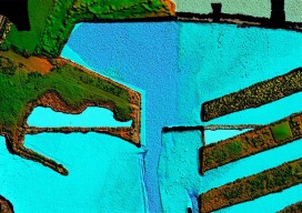
From Shore to Floor
Today’s technology records depth from land to deep waters accurately and efficiently. More than 90% of the world’s trade is carried by sea, according to the International Maritime Organization. Therefore, accurate and up-to-date charts of coastal waters for ship navigation are vital for world commerce. The current expansion of the Panama Canal, which will double...

Q&A with 3D Guru TJ McCue
Autodesk is sponsoring an eight-month 3D RV (recreational vehicle) 100 stop tour of the U.S. that celebrates the future of how things are designed and made. Led by TJ McCue, host, writer, and 3D enthusiast, the 3D RV tour is visiting America’s cities, towns and off-the-beaten path byways to explore a powerful and fundamental change...
How to Talk with Clients About Laser Scanning
Clients should choose a laser scan primarily when they need to document existing conditions for a future construction or complex renovation project. When complex conditions exist, the risk of a mistake using a tape measure and sketch pad greatly increases the probability of a construction error. If this matches our clients’ needs, we then discuss...
When to Use Laser Scanning
Some clients don’t understand the benefits of point cloud data and how it can be leveraged. At my company I talk to them about how laser scanning might fit the type of project they have as well as the potential cost savings. First and foremost, collecting and using laser point cloud data on your project...