Tag Archives: OS

Who are the “Geo6” and why will this change UK geospatial?
Around the middle of 2017, there was a mumble in the geospatial industry about how the UK government was going to open up more of its geospatial data. There was even an outrageous rumor that Ordnance Survey was going to have to release its multimillion-pound product, Mastermap. Everyone sniggered but watched the news like hawks....
OS Zoomstack – the Gift that Keeps On Giving
On July 17 2018, Ordnance Survey (OS), the United Kingdom’s national mapping agency, released a trial of a product called “OS Zoomstack.” At the time many overlooked it, as Ordnance Survey makes lots of their data over 1:5000 available for free. I have to admit I was one of them. In August of last year,...
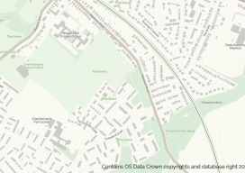
Recreating the Ordnance Survey Explorer Maps with Open Data
The holy grail for many (UK) map users is the Ordnance Survey 1:25,000 scale “Explorer” map. Not only are they easy to read due to the fantastic cartography used, but they also have information which is hard to source such as public rights of way, National Trust & Woodland Trust sites, even wind farms. To...