Tag Archives: remote sensing

xyHt Digital Magazine: July/August 2024
xyHt magazine’s July/August 2024 issue focuses on surveying and mapping, with an in-depth look at a map maker of the future and a profile of up-and-coming Stonex. As always, if you don’t have a subscription to our print edition, or if someone else in the office has snaffled your copy, don’t fret, here is the digital...

Greg Saunders
24 Young Geospatial Professionals to Watch in 2024 Company: DOWLCurrent position: Surveyor/remote sensing scientistAge: 34Education: MS natural hazards, University of Oslo; BS geological engineering, University of Nevada, Reno Saunders has followed a winding path to get to where he is today, but a few things have stayed constant—his desire to learn and his love of...
Kayla Keller
24 Young Geospatial Professionals to Watch in 2024 Company: WoolpertCurrent position: Geospatial team leader, remote sensingAge: 33Education: MS, GIS, University of Washington; BS, geography, Ohio State University Keller is a geospatial team leader who focuses on project phase management as well as remote sensing priorities. In this role, she assists with the management of planning,...
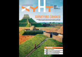
xyHt Digital Magazine: April 2023
xyHt’s April issue focuses on surveying, including modern technologies being used in a massive geophysical survey and historic equipment that got the profession to where it is today. As always, if you don’t have a subscription to our print edition, or if someone else in the office has snaffled your copy, don’t fret, here is the...

Bridge Watchers
Smart sensors and satellites are being used to actively monitor bridges and large infrastructures. With eyes in the sky and ears on the ground, can this new technology improve public safety? Despite what the lyrics of the popular English nursery rhyme may have our young ones believe, the London Bridge has actually never fallen down. ...

Adailin Lebron Bengochea
23 Young Geospatial Professionals to Watch in 2023 – 14 of 23 Name: Adailin Lebron BengocheaCompany: City of Grapevine, TexasCurrent position: GIS Engineering SpecialistAge: 33 Education: MA Geo in GIS, Texas State University; BS in Geography and Anthropology, The University of Texas at Austin Although Bengochea has always enjoyed a good map and navigating atlases...