Tag Archives: solar

Ocean Observation
Monitoring and comprehensive data collection is now a national security imperative For most of the second half of the last century there was general agreement that the primary existential threat to humanity was the purposeful or accidental exchange of nuclear weapons. While that threat has not been completely eliminated, in the 21st century there is...

xyHt Magazine November 2016 Issue
Click here to view the November 2016 issue of xyHt magazine.

Robots
Above: GPS-controlled robots can measure a site fully automatically and precisely anchor screws for the foundation of a solar plant. Measuring and Anchoring As a child I used to watch a program on BBC television called Tomorrow’s World. Once in 1981, I sat in awe as it showed a snooker-playing robot. My dreams were filled with...
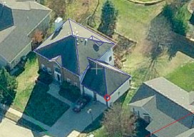
EagleView
The practical side of on-demand aerial image analytics, with an interview of CEO and president Chris Barrow. A contractor showed up at my house to give an estimate for a long overdue roof replacement. He hadn’t pulled out a ladder, so I asked if he needed mine. His response was, “Since we started using EagleView,...

Big Data, Public Data
Above: A lidar-derived elevation raster DSM (of Dinkytown, MN) draped by an aerial photo. Free Aerial Lidar, Renewable Energy, an Infectious Mentality At the intersection of renewable energy, big data analysis, geospatial technology, and public data availability stands the Minnesota Solar Suitability Analysis project. Primarily manned by students in the University of Minnesota Master’s of Geographic...