The practical side of on-demand aerial image analytics, with an interview of CEO and president Chris Barrow.
A contractor showed up at my house to give an estimate for a long overdue roof replacement. He hadn’t pulled out a ladder, so I asked if he needed mine. His response was, “Since we started using EagleView, I don’t really have to climb up there anymore.” Instead, he pulled out a seven-inch semi-disposable tablet and showed me a fully dimensioned image of my roof that he’d ordered online the day before, and he cranked out an estimate on the spot.
Chances are that you may have been a downstream client of one of many such services that EagleView has been providing for roofing contractors, developers, assessors, and insurance companies—without even realizing it. What this contractor demonstrated to me is a real example of the fruits of “big data” and Software as a Service (SaaS). It was an example of how traditional markets for geospatial services have and will continue to change rapidly.

EagleView roof and wall reports are derived from Pictometry’s library of oblique georeferenced images of each structure from multiple perspectives.
Big (Aerial) Data
“If you think about big data, it doesn’t get any bigger than this,” says EagleView CEO and president Chris Barrow in a recent interview with xyHt at the headquarters of the now-merged EagleView and Pictometry companies. Barrow is referring to the massive library of aerial imagery collected by Pictometry over the past 15 years that encompasses 98% of all structures in the U.S. It contains not only orthophotos, but also oblique imagery from multiple angles.
Many geospatial professionals are already working with imagery from Pictometry, the company that just about single-handedly invented the commercial oblique aerial market. In the heart of the optics and imaging industry and research environment of upstate New York (specifically Rochester, where there is a long legacy of companies the likes of Kodak and Bausch and Lomb), Rochester Institute of Technology professor John Ciampa filed for the earliest patents for working with oblique aerial imagery; this was the early 1990s. Within a decade, these roots led to the formation of Pictometry, which captures and licenses aerial imagery for over a thousand U.S. counties plus federal agencies and state, local, international, and private entities.
Their fleet of 80 planes, typically single-engine, are equipped with Pictometry’s tightly specified or wholly designed and patented camera systems. The crafts utilize integrated GNSS and inertial POS AV geo-referencing systems (with some proprietary augmentations). While they do not require the dense networks of ground targets as would legacy aerial mapping, there are sufficient ground targets for calibration. Pictometry also retains licensed surveyors and photogrammetrists for products subject to specific contractual requirements. With more than 30 million images per year, EagleView continues to amass one of the leading examples of big data captured from aerial imagery.
The licensed image sets that a county might contract for on an ongoing basis have become seemingly ubiquitous and accepted, sort of as an
expected base resource. This represents a shift away from traditional “time and materials” style ad hoc aerial surveying contracts. Direct customers of Pictometry orthometric imagery, plus those who are downstream users via licensed sets, represent an almost limitless variety of geospatial uses. But it was the oblique imagery that sparked an entirely new service model.
Up on the Roof
If you’ve ever tried to accurately measure a roof, it can be both a hazardous and frustrating exercise. Things are not always square, you’re trying to hang on while pulling a tape measure, and you need to work out the trigonometry of complex gables and slopes. Certainly with a surveyor’s robotic total station and the fairly recent advent of reflectorless laser measurements, you could (with several setups) generate an accurate model. But this is not an inexpensive proposition and not readily available to a contractor trying to process estimates quickly and efficiently.
Barrow tells the tale of a roofing contractor, Dave Carlson, who had been seeking ways to more efficiently and safely measure roofs. He’d tried everything, including tying a string to a tennis ball and catching it on the gutter on the opposite side, then measuring back up the string, but still the solution seemed elusive. When he reached out to his software engineer brother-in-law Chris Pershing, the pair began to look into photo-based solutions, and they found an amazing resource.
Pictometry had existing oblique images of nearly every structure in the country, taken from a 45-degree angle with up to a dozen perspectives on each structure. Their early development was tested with simple cameras and birdhouses, but the solution proved solid with the structural images, and EagleView was born in 2008.
A variety of services grew from the initial simplified roof measurement reports, and these patented products were further developed into an online easy-to-order roof and wall system. The services would soon include change detection, post-event disaster response, and roof and wall reports. In 2013, Rochester-based Pictometry and Bothell, Washington-based EagleView merged into EagleView Technology Corporation, under the helm of CEO and president Chris Barrow.
Grapes, Grape Juice, and Wine: an Interview with EagleView CEO and President Chris Barrow
xyHt: What attracted you to EagleView and what did you bring to the table?
Chris Barrow
CB: I was looking for a new opportunity when I was contacted by a recruiter. I went out to meet the team at EagleView [then] in Woodinville, Washington.
At the time there were many companies that had very interesting technology solutions, but I was finding that many of them did not solve any specific business problem. They had developed an interesting product but they were waiting for a business need to develop. I really liked that at EagleView there was a situation where there was a real need for roofing contractors, and the team who had developed the solutions were directly from that industry. The solutions they developed also tapped into existing resources, in a unique way.
EagleView was at that point where they needed someone to take it to the next level. There is a book out called Zero to One, examining the specific set of skills to take a company from zero to its first dollar. It also talks about the completely different set of skills that it takes to go from the second dollar to millions. I don’t think I’m the kind of guy who could take it to its first dollar. When I first came into the business it was just a few people, and they deserve a tremendous amount of credit. They had the skills to come up with a great idea, a great solution, and then realized they needed help with the next steps.
At the time there was a small board of investors who had put some money into the company. Their direction to the founders was, “We think you have a real business here, but you need a couple of things: you need more money, and you need a real CEO who has done this before. We don’t have more money to put towards this, so if you find the right CEO they can bring the right investors.” That is typically what a CEO of a small start-up does.
The fun part of the story was that, at the time, the founders had a small amount of money left in the bank and they took the rest to retain a recruiter. Every business that is a success has several “bet the farm” moment” and this was one. Had that decision turned the other way, there would have been a completely different outcome. Throughout the years with EagleView, we certainly have had our fair share of those moments.
xyHt: Concerning the merger with Pictometry, who approached whom?
CB: It was a lengthy process. We approached Pictometry with the idea of strengthening our relationship. We wanted to have a more strategic partnership rather than just a vendor relationship. I think that led to internal discussions at Pictometry along the lines of whether they should engage in a deeper relationship, develop their own products, or maybe buy a company like us.
We approached them with the idea of buying them, and it was a strange courtship over a couple of years. Eventually we came to the conclusion that the value proposition of bringing these two companies together would really create a unique vertical integration—a core supplier and finished-goods company working together made sense.
xyHt: To merge companies of similar size is hard to do (and almost never done), but you have succeeded in doing this.
CB: Mergers often succeed or fail depending on whether clashes in business cultures can be worked out. I think it is true of Pictometry and also for EagleView that each company in its own space was an inventor who then created solutions and became a market leader in their respective fields. Pictometry invented the oblique imagery marketplace
and executed that very well with patents. EagleView also invented specialized services along with filing a number of patents. From a business perspective our cultures matched. We have also been very focused on the concept of work hard, play hard. We believe that mantra helped us create a universal culture that start-up mentalities can relate to; that really helped us create a strong bi-costal company culture.xyHt: Being the first to do something: there was no one before you to learn from, but those to follow could build off your experiences. Was this a worry?
CB:Our fear for both companies in the beginning was that we would be one of those unfortunate companies that invented something first, but then it would be the second or third company that came after us that was really the one that made it take off and become the market leader. We never wanted that to happen.
We are very protective of the fact that we invented multiple technologies and made them marketable. We did not want to lose what we created. Both companies had a strong history that is still in place today based on the ability to execute. That is really why the synergies and the commonalities between both companies worked—we had both been successful in invention and execution.
xyHt: EagleView took the resources of big (imaging) data and built solid, but elegantly simple solutions from it. Where do you see your development going from here?
CB: I like to use the analogy of grapes and wine. Pictometry: they are best in the world in producing aerial imagery and they are unmatched for their oblique imagery. That makes for excellent grapes. EagleView takes the grapes and squeezes them on demand, making grape juice; send us an address and we will create a roof report. We are now moving towards the ability to create more of a winery. We take these images, or grapes, and extract the best parts proactively. We are able to then create products that can sit on the shelf or in a database or series of databases so when the customer needs it we can deliver instantaneously. It will be a growing variety of data that can be delivered 24/7.
If you think about it, we are in a unique position because we have been collecting this data for 15 years. We have a massive library that covers 98% of all structures in this country, many of them with hundreds of photographs going back over a decade. There is so much incredible data you can mine, not just the different data elements that are connected to the structures and within the property but also on the growing need for change detection. Knowing how a property has changed over time helps in determining value, hazards, insurance considerations, zoning, and assessments. We are seeing growing opportunities and expanding applications.
xyHt: Are there plans for expansion overseas?
CB: We have over the past years developed a network of overseas partners and affiliates—imagery in 25-30 countries—South Africa, Australia, South American countries, Japan, etc. We tend to be opportunistic at this time. Probably we’ll see 2015 continue to be opportunistic, but in 2016 … watch out! We’re in the process of revamping our international plan and firming up our domestic plans first.
xyHt: The advent of successful SaaS and big data mining is happening at the same time as a re-evaluation of some of the conventional wisdom about GIS, mapping, surveying, asset management, with a lot of emphasis on redefining roles. In light of this, what advice do you have for the geospatial professions?
CB: An ongoing piece of advice that I offer is to not get hung up on labels. Start-up endeavours need to look for the practical solution. A new company should ask what their customers are looking for; the answers may be outside of [legacy roles and silos]. They need to figure out how to answer a question that someone will be willing to monetize. The closer they can come to fully answering that question with as much detail as possible will let them provide a valuable, marketable product.
Perfect example: we capture excellent imagery. The pictures are beautiful while also being georeferenced. We find ourselves sometimes getting wrapped up in the “wow, isn’t this amazing and cool!” But at the very core our customers really want us to tell them what is in that image: measurements, change, risk. They need this to know and understand what impacts there may be on someone’s tax assessment, insurance claim, or new roofing system.

On the Floor
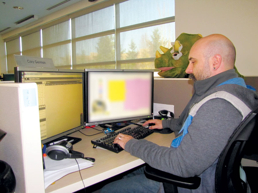
The rapid processing of a roof report is demonstrated by EagleView’s Cory German. The team attracts technicians from a wide variety of fields who demonstrate particular aptitude for working in 3D environments, some from the gaming industry.
The production floor of EagleView’s Bothell, Washington headquarters is a sea of low-walled cubicles, multiple monitors, and plenty of geek trinkets (Barrow notes that quite a few Nerf gun fights erupt there). The technicians who process the orders placed online come from a variety of backgrounds, geospatial and non-geospatial. The region is world-renowned for tech giant companies (so the pool of developers is quite deep) but also for the gaming industry, and the technician I spoke with comes from the latter. Gaming industry folks and their generation have grown up in a digital 3D environment. EagleView even developed a test for 3D aptitude and found that their staff scored highly; the test is employed to some degree in evaluating new staff.
Regarding the EagleView process, when the request comes in online, often a street address and report type is all that is needed. The assigned technician views the structure from multiple oblique perspectives and rapidly sets points common. They identify the ridgelines and edges of the roof, ultimately creating a 3D model. The “drafting” for a QuickSquares report (EagleView’s newest roofing report) can be done in minutes, and after QA/QC steps by another tech, the square footage and predominant pitch of a roof is ready for a roofing contractor to use to build an estimate. There are a variety of other roof and wall reports that can even include DXF for export to CAD. For structures or properties outside of the Pictometry image coverage, other imagery (including satellite) can be used.
At one end of the floor some of their developers are at work. One gave us an overview of a change-detection solution he is working on for insurance companies and county planning departments. Barrow noted that the level of interest by the insurance companies exceeded their expectations, but that extended services like lidar and infra-red, though steadily growing, were not as popular as one might expect. He thinks this is because most of the answers clients are seeking can be derived by photogrammetry.
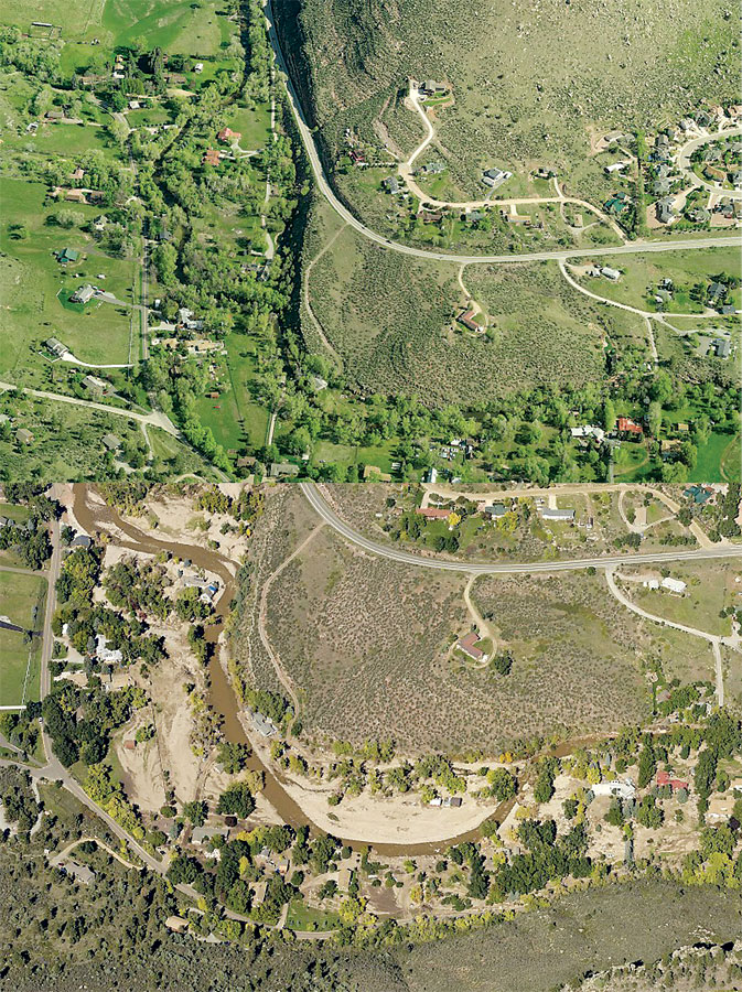
As part of their rapid imagery services for disaster response and post-event analysis, EagleView deployed aircraft in response to the 2013 Colorado flooding.
No Small Change
The penetration of such services into roofing, assessment, development, and insurance has been nothing short of astounding—but has gone somewhat unnoticed by many in traditional geospatial fields. I quizzed a number of geospatial practitioners; most were minimally aware of such on-demand image analysis and report services.
Questions get raised about what elements, if any, of such services might fall under certain states’ specific definitions for licensed and regulated professional services. But on the other hand, some note: Does an activity like a roofer estimating a roof with a tape measure suddenly run afoul of regulation simply because a new tool is being utilized?
There will be many angles to consider as SaaS becomes more prevalent, and despite issues to work out, just like with UAS and mobile mapping, the reality is that such services have been proven to provide fit-for-purpose verifiable and independent results. The impact and cost-benefits are undeniable.
The question may not be so much what to make of SaaS services like EagleView provides—these are here to stay and will continue to grow—but what such services can do for you.