Measuring and Anchoring
As a child I used to watch a program on BBC television called Tomorrow’s World. Once in 1981, I sat in awe as it showed a snooker-playing robot. My dreams were filled with the expectation that our lives were about to change forever as robots would be doing much of our manual work.
Unfortunately that day never came, but my inner child was awakened again recently when I came upon a brochure for a fully autonomous solar installation machine from the German company Krinner Schraubfundamente GmbH.
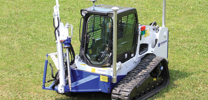
With its self-developed special machines and tailor-made solutions, the Krinner company, from Lower Bavaria, Germany, provides ground screw foundations for solar power plants throughout the world. GPS-controlled robots measure the site fully automatically and then precisely anchor the screws. This enables special mounting frames to be erected within the shortest possible time: without concrete, completely sustainably, and efficiently. These innovative machines are adapted to the local conditions and can be used for almost all ground conditions.
Krinner has developed a fully automated solution for solar installation, with an autonomous drone, which captures the 3D surface, and an innovative autonomous vehicle that can install screw poles on most terrain with precision and speed. Curious about how such a system could work, I interviewed the experts at Krinner Schraubfundamente to get more information.
xyHt: You use a drone that captures a 3D surface. This then informs the piling vehicle of location, but how does the piling vehicle calculate the depth required?
Krinner: For our purpose the pre-drilling is performed to a predefined depth. This depth is also fed back to the system to document the depth of each point in the 3D models. A variation could also be realized, so if there’s a special need for different depths this could be programmed. However, this is not necessary for the purpose of solar installations.
xyHt: This system obviously reduces the issues of error from human interaction, but how much faster is this system compared to the standard method of the pegs being put in and someone driving around and piling?
Krinner: This KRM machine was designed for solar installations. The installation speed is very high: the cycle time per point is 15-20 seconds. The efficiency [has] increased dramatically as the machine combines three installation steps into one.
Previously the surveyor-team came to site (step 1) and determined the points (step 2). Then a machine team pre-drilled the hole on that location (step 3). The KRM is able to do all these steps in parallel. Also, they don’t need to put a flag on the location but spray with a biodegradable color (similar to the one used in soccer fields). Therefore, the expense for the flags can also be saved.
xyHt: Are the vehicles fully autonomous? If so, how do they navigate and to what level of accuracy?
Krinner: Yes, it works fully autonomously. Still, there has to be one operator due to safety regulations (but he’s not steering the vehicle in any way). The navigation works by GPS, movement-sensors on the tracks of the bobcat, and inclination sensors. The accuracy is usually around 1 cm. Depending on the soil it could vary up to 2 cm.
xyHt: Has this system been used in any current solar projects?
Krinner: It’s used in all our ongoing and future projects, including Europe’s largest solar farm in Cestas near Bordeaux. Internally, the KRM revolutionized the workflow on site and continues to do so with the development that is far from its peak.
We were able to reduce costs threefold: 1) the cost of surveying, 2) the cost of installation, and 3) the cost for our racking system, as the increased accuracy allowed us to develop more cost-efficient racking systems with smaller tolerances. Further, it enabled us to optimize our quality management system on site.
xyHt: Do you have other autonomous or geo-based technology in development? What does the future hold?
Krinner: Realized is the Krd60, a GPS-guided machine that installs foundations according to the positions the KRM set out. That is a manually operated installation machine where the positioning is done by GPS; hence the possibility of human error is reduced a lot.
Our next step in evolution is the KRT, which is still under development and combines the KRM and the KRD 60, so a machine that covers everything from the surveying to the installation of the foundation, all steps.
The main enabler of this technology is also the Krinner Cloud that integrates all processes on site and in the engineering. That allows an almost simultaneous planning and installation progress. Changes in design can be realized in almost real time on site, which gives us a real edge on competition in terms of realization speed and quality/change management. n