Tag Archives: survey
Transformation of Observations, Part 3
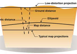
Above: Typical and low-distortion map projections. Using a Project Factor In Part 1 of this series of articles (September 2014 issue), I explained how to transform surface observations into a geocentric coordinate system so that it could be compared to GNSS baseline vectors. In Part 2 (December 2014) I explained how the creation of a...

The Note
From this crest of the Grand River Basin, near Byers Canyon, Colorado, the survey crew of Igor Kidinsky, aka Eager (The Kid), and Glenny Dale, aka Glutton (The Old Man), can view the same grandeur as the first survey crew who stood here 130 years ago, imagine the same thoughts, and make the same notes:...
Survey Web Tools
How to use them for land survey planning and reconnaissance. When I first used GNSS, it was my usual practice to go to the National Geodetic Survey (NGS) website to gather the data sheets for control monuments in the vicinity of my project area. I would plot these in a program called TopoScout, a topographic...