Tag Archives: surveying

The Dog Whisperer — Not Me
Surveying in the field exposes all of us to various threats from flora and fauna, not to mention the two-legged threats. It just comes with the job. Depending on location, we learn to identify and respect the diverse threats to our beings while conducting the course of our mission. They are just part of the...
Citizen Geodesist
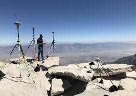
A GPS on Bench Marks odyssey Philip Melcher of Provost & Pritchard Consulting Group in Visalia, California, has submitted GPS on Bench Marks observations on an incredible 650 Bench Marks all up and down California in the last three years. We will ask Philip a few questions to find out how he has accomplished this,...

xyHt Weekly News Recap: 03/04/2022
Register for the March 30 NSPS Day on the Hill Carlson Go West 2022 Set for April 4-6 ProStar Granted Major Patent for Utility Data Management RIEGL & Deswik: Providing a Fast and Efficient Workflow for Mine Surveying Emesent Hovermap Sets Survey Grade Standard for Autonomous Lidar Mapping NCEES Seeks Professional Surveyors’ and Mapping Scientists’ Expertise...

Rewriting Legal Descriptions
What’s up with rewriting legal descriptions? There seems to be a growing push from the title companies to have legal descriptions rewritten for little or no good reason. In my 38 years as a licensed surveyor I can remember but a few instances when rewriting a metes and bounds description was truly warranted and recommended,...
The New Datum and Real-Time GNSS Networks
We asked U.S. RTN what their plans are for the upcoming changes to the National Spatial Reference System. When it comes to geodetic reference frameworks, “shift happens.” Surveyors (and others) have been through this before, like changes from NAD27 to NAD83, NGVD29 to NAVD88, from NAD83(CORS96) to NAD83(NSRS2007), and to the current NAD83(2011). Remember the...
xyHt Weekly News Recap: 02/18/2022
Riegl Instruments Used by Projects that Win MAPPS Geospatial Excellence Awards Geo Week Exceeds Expectations Trimble Introduces Catalyst GNSS LAND INFO Announces Updated 10m USA Countrywide Land Use Land Cover Mapping Dataset XMAP Cloud GIS Brings Government Flexible Working Closer to Home Sonardyne Launch Wireless Seabed Unexploded Ordnance Disposal Capability Fugro Joins UN Ocean Decade...