
Introducing UAV LiDAR
 When the idea of integrating LiDAR (Light Detection and Ranging) technology into unmanned aerial vehicles (UAVs) first emerged, it sparked a new paradigm for both technologies. Suddenly, UAV operators not only gained a bird’s eye perspective of the land their aircraft flew over but also the ability to simultaneously generate 3D maps with ease. It sent waves of excitement across several industries, from agriculture and forestry to construction and surveying.
So far, much of the discussion in these industries and tech circles has been focussed on the use of LiDAR for data collection, object identification, robotics and autonomous cars. Yet, one frequently overlooked area is how the integration of navigation systems could greatly improve UAV LiDAR applications, particularly in surveying.
Why accurate navigation is crucial for UAV LiDAR
LiDAR operates by emitting light pulses and measuring their return times to determine the target’s relative position in three dimensions. Data points are collected at a rate of millions per second, enabling highly detailed maps to be automatically generated. This requires simultaneous calculation of the target’s position as well as keeping track of the UAV’s position and orientation during flight.
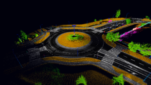
Image caption: Example of a LiDAR survey point cloud. Image courtesy of EyeVi Technologies.
This is where inertial navigation systems (INS) come in. They can provide the georeferenced position, navigation and timing (PNT) data needed for UAV LiDAR to carry out mapping and surveying tasks with exceptional precision, efficiency and safety.
Improving data collection with navigation solutions
Australia’s Nextcore is one company pioneering the adoption of next-generation UAV LiDAR. One key trend they have observed is the increasing demand for UAVs capable of surveying at higher altitudes, particularly from clients working in challenging terrain.
In a recent product build, one key requirement was to design a UAV LiDAR capable of capturing survey-grade data from 80 meters AGL (above ground level), twice the industry norm. Maintaining survey quality at this altitude, however, requires a LiDAR system paired with an ultra-precise INS. Advanced Navigation’s Certus Evo, a MEMS-based INS boasting performance comparable to a fiber optic gyroscope, proved to be the ideal solution.
Certus Evo demonstrated key advantages over competitors. It was highly accurate, cost-effective, easily integrated, and available in OEM format, making it a superior choice for customers. The end product for Nextcore was a UAV LiDAR capable of surveying areas in hard-to-reach and obstacle-laden environments from up to 120 meters high – exceeding their initial goal by 50%.
Have we reached the ceiling?
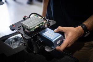
Image caption: Nextcore’s RN100 UAV-mounted LiDAR, featuring Advanced Navigation’s Certus Evo, a compact, high-performance INS.
Despite the success of UAV LiDAR technology across many industries, traditional aerial surveying practices, which rely on piloted aircraft and photography, are still prevalent due to concerns around the expense of UAV LiDAR equipment and its data accuracy in difficult settings.
As navigation technologies continue to improve, there is no doubt UAV LiDAR will be able to play an increasingly dominant role in terrain mapping and surveying tasks, offering unmatched accuracy, efficiency and cost-effectiveness.
For more information about Advanced Navigation’s case study with Nextcore, please visit advancednavigation.com.au or scan the provided QR code.