Tag Archives: surveying

xyHt Weekly News Recap: 05/06/2022
NSPS to Host Virtual Town Hall on Davis Bacon Act Regulations LiDAR for Drone 2022 Conference Set for June 13-14 in France World’s First Expandable Wing UAS Launches at AUVSI XPONENTIAL Army Corps of Engineers Picks Aero-Graphics for Geospatial Mapping and Surveying High precision mapping and automated workflows IDS GeoRadar launches cloud-based AI solution AiMaps...
Solving the Problems that Matter
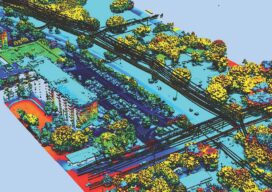
Pickett and Associates provides aerial LiDAR and imagery, land surveying, hydrographic surveying, and engineering services to clients throughout the U.S. and Caribbean. Pickett specializes in offering the simultaneous collection of high resolution 4-Band Aerial Imagery together with engineering-grade airborne LiDAR, allowing us to turn around baseline imagery and LiDAR-derived data quickly and efficiently. We deliver...

When a Drone Just Can’t Do It
There is a growing ebb in the tide of UAS adoption for aerial surveying, mapping, and remote sensing—finding the right balance between manned and unmanned aerial operations Unmanned aircraft systems (UAS), remotely piloted aircraft systems (RPAS), or just plain old “drones”—call them whatever you wish—have had a tremendous impact on geospatial industries. A decade ago,...

Legal Boundaries: The Ultimate Issue
What is the “Ultimate Issue Rule” in civil litigation? The Ultimate Issue Rule refers to Rule 704 of the Federal Rules of Evidence. The Federal Rules of Evidence (the Rules) were submitted to Congress by the Supreme Court in 1973, approved and enacted in 1975. They were intended to bring uniformity across all federal courts...
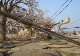
Surveying, Drones, and Danger
Experts say drones carry the promise of keeping the electrical grid safe amid increasingly intense storms The greater number and intensity of severe storms in the United States has communities rethinking their infrastructure. They’re making streets and parking lots permeable to absorb excess rainfall and rebuilding natural watershed features that help prevent floods. With the...
xyHt Digital Magazine: April 2022
Like a good surveyor, xyHt‘s March issue covers a lot of ground, bringing you stories about surveying, mapping, UAVs and, this month’s special, a look at how drones are becoming indispensable on construction sites. As always, if you don’t have a subscription to our print edition, or if someone else in the office has snaffled your...