Tag Archives: surveyor

Farrah Etcheverry
23 Young Geospatial Professionals to Watch in 2023 – 11 of 23 Name: Farrah EtcheverryCompany: Etcheverry Land Surveying LLC. (ELS) Current position: Co-owner and Survey TechnicianAge: 29 Education: Associates Degree from Yavapai College, currently pursuing a bachelor’s degree in Land Surveying and Mapping with an emphasis on photogrammetry from East Tennessee State University Working under...
James Richards
23 Young Geospatial Professionals to Watch in 2023 – 7 of 23 Name: James RichardsCompany: Benchmark SurveysCurrent Position: Survey Manager–Land, Utility and Measured Building SurveyorAge: 29 Education: Level 3 Surveying Technologies Theory; Level 3 Utility Mapping and Surveying Biography: Richards came out of school chasing the dream of becoming a professional footballer. He signed a...
Inspiring the Next Generation of Surveyors
Looking Forward White, middle-aged men in high-vis jackets—what most people visualize when they think of surveyors—isn’t a very appealing career option for our youth, especially compared to idolized professions of actress, athlete, doctor, or even YouTuber. In fact, ask any child what they want to be when they grow up, and chances are they’ve probably...
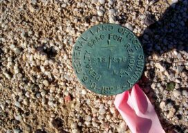
Legal Boundaries: Monuments and Corners
Is there a difference between a monument and a corner? Many surveyors use these two terms interchangeably as if they were synonymous. Technically speaking they are not the same, but in many instances a monument will be the physical manifestation of the true corner location. This is the ultimate surveying question, is that monument actually...

Embracing the Drone Revolution
Surveyor business models changing in the BVLOS era Over the past few months, the Federal Aviation Administration (FAA), working with the drone industry, academia, and general aviation membership organizations such as AOPA (www.aopa.org) and NBAA (www.nbaa.org), has been able to advance the cause of uncrewed flights beyond visual line of sight of the operator (BVLOS). ...

xyHt Weekly News Recap: 10/15/2021
URISA Leaders Recognized at GIS-Pro 2021 Aero-Graphics Hires Daryl Southard as Director of Business Development Dewberry Acquires the Latest RIEGL VQ-1560 II-S Airborne LiDAR System Seamless, Automatic Thermal Imagery Based Inspection Available now for Remote Digital Inspections AI Surveyor is First Intelligence Platform for Large Infrastructure Projects Septentrio, ArduSimple Bringing Reliable GPS/GNSS to Emerging Applications North...