The following is xyHt’s 2020 collection of 40 under 40: profiles of motivated and accomplished young professionals under 40 years of age. Click on each name to view their profiles below.
Kwabena Obeng Asiam

- Researcher & Lecturer – Leibniz University
- Published PhD candidate in land administration; FIG Young Surveyors
- Ghana
- Evaluating the evidence and making professional judgement in matters of individual land parcels and bona fide real property rights is challenging enough; imagine seeking to resolve the issues of land tenures for large regions. Such matters are part of the studies and research of Kwabena Obeng Asiama. With the societal challenges requiring a good land administration system, Kwabena’s PhD research and publications focus on ways to better transplant land management activities that have worked in one region of the world to another, whilst taking into consideration the local conditions of the recipient locality. Kwabena has published widely in this area, with one of his publications winning the FIG-Survey Review Award at the XXVI FIG Congress in Istanbul. Kwabena is currently a research scientist at the Geodetic Institute of the Leibniz University of Hannover, Germany. As the current Vice Chair of the FIG Young Surveyors Network, Kwabena enjoys working with young international colleagues to promote the surveying profession to get younger people into the profession.
Victoria Donko 
- Geomatics Engineering Student – York University
- Association of Ontario Land Surveyors
- Henriette Verhoef Student Award
- Canada
- Victoria Donko has decided to follow in the footsteps of grandfather, mother, and uncles in choosing surveying as a career. She often finds herself as the only female surveyor in the room and has helped in outreach to others breaking new ground in the profession and encouraging other young people to consider careers in geomatics. She has been awarded the Henriette Verhoef Student Award from the Association of Ontario Land Surveyors for her work and achievements while a student at the Lassonde School of Engineering’s geomatics program.
Mark Counts
- Chief of Office Survey Systems – California Department of Transportation
- Program Facilitator, Surveying and Mapping Dept. – Santiago Canyon College
- California
- Mark is a 37-year-old PLS in California who has greatly contributed to the profession through his involvement with Santiago Canyon College. He has been a guest author at xyHt (the Three E’s). In the opinion of his nominators, Mark’s energy, enthusiasm, and thirst for knowledge set him apart from many surveyors of his generation. He is constantly looking for ways to reach young people to infect them with the surveying bug. In addition to the time he commits to the profession through his employment with Caltrans and work with the college, he balances family life as the father of three young children.
Lauren Holland 
- Land Surveyor & Geospatial Consultant – Murphy Surveys, monitoring lead
- Project surveyor, building surveys, career outreach
- United Kingdom
- Lauren has been recognized for multiple STEM, outreach, and rising star accolades, but is first a skilled surveyor taking on roles of increasing responsibility and in adaption of new technologies. But you may know her (or follow her) by her geo-social-media handle @Geospatiallauren on Twitter. We predict that Lauren become a rising star in the emerging geo-social-media wave that is becoming essential to keep the profession fresh, up-to-date, relevant, and appealing to young folks who are considering geospatial careers.
Brandon Barker 
- Software Engineer and Student – West Chester University
- Pennsylvania
- The geospatial future will be substantially molded by advances in software, and talented programmers are essential. While continuing his studies in computer sciences, Brandon has earned high praise from his work interning at several rising and influential geospatial companies. These include Cesium, comm.ai, Dokkio, Yugorsky, Airphrame.
Jo Jensen 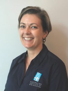
- Survey Coordinator – Land Surveys
- Civil, construction, earth-moving, mining & land development
- Australia
- Jo studied geomatics engineering at Melbourne University and graduated with honors. Her career has included postings as surveyor, and survey sales support and training for a prominent Leica Geosystems dealer, but gained a particular affinity for mine surveying and has served on committees for the Australian Institute of Mine Surveyors. To say that mining and mine surveying are “big” in Australia would be an understatement, despite some of the ups and downs of the industry. Her roles at her current posting, Land Surveys in Western Australia, continue to support the mining sector as well as other surveying services for other disciplines.
John Louie Fabila 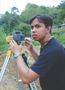
- Geodetic Engineering Educator – University of the Philippines
- UP-DREAM: Disaster Risk and Exposure Assessment for Mitigation
- Philippines
- John Louie Fabila has received more nominations than anyone in our years of presenting the 40 under 40. This geospatial leader and educator from the University of the Philippines Department of Geodetic Engineering is putting the Geodetic Engineering profession in the limelight through his superb presentation of its importance in our everyday lives. As one of his nominators stated: “He is quite an effective speaker and has impressed a lot of co-professionals and students because of how he provides spunk to his presentations, such as ‘Why you should shift out of the Geodetic Engineering course,’ which highlights how cool the course really is. His creative ways in presenting geospatial data on social media not only educated his followers but also provided a boost on the morale of geospatial experts on their importance in the society.”
Agata Fischer 
- Business Director, Detection and Services – Leica Geosystems
- Ground penetrating radar and construction tech
- Switzerland
- While her academic background was in business process and marketing, Agatha has gained an exemplary understanding of geomatics and geospatial theory, practice, and especially emerging technologies. Her steady rise, first within Hilti and since within Leica Geosystems, is impressive, but what brought Agatha to our attention was her presentations and writings. Being both tech- and business-savvy and an excellent presenter is a potent combination; the multi-lingual Ms. Fischer is all of the above.
Robert Griffin 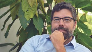
- College of Science Associate Dean – University of Alabama, Huntsville
- Mission Operations and Science Lead, NASA Sally Ride EarthKAM
- Alabama
- His nomination letter from a colleague says it best: “Rob Griffin is a geoscientist and environmental anthropologist with the University of Alabama in Huntsville, where he partners with colleagues at NASA’s Marshall Space Flight Center in projects on international capacity building through applied Earth sciences In addition to a PhD, he holds certifications in remote sensing (CMS/RS) through ASPRS and GIS (GISP) through GISCI. In his courses he uses GIS as a tool to communicate the human impact of global environmental change to undergraduate and graduate students from multiple academic disciplines. As an environmental anthropologist, Rob spent years conducting archaeological investigations in the tropical forests of Central America. His surveys in the tropical jungle employed precision GPS, total station survey, and satellite remote sensing, research which led to a graduate research fellowship with NASA. Sustainable growth, a term that comes up often these days, was critical but challenging for prehistoric civilizations, and part of Rob’s research was to infer then map patterns of growth (at times sustainable, at times not) over the landscape history of Central America. Today, Rob manages a team of over 20 research scientists and graduate students through federal contracts and grants in geospatial analytics and applied satellite remote sensing.He serves on multiple boards of directors, attends and presents scientific work at professional conferences, and mentors students in professional development. He is one of the most loved and respected professors on the campus of the University of Alabama Huntsville.”
Melissa Harrington 
- Chair, FIG Young Surveyors Licensed cadastral surveyor
- Product Manager – Trimble
- New Zealand
- Melissa, who earned her Bachelor of Surveying (and spatial science) from the University of Otago in New Zealand, and began her surveying career there. Always active and a leader in professional organizations, such as the New Zealand Institute of Surveyors (NZIS), Melissa is now chair of the FIG Young Surveyors. She has also applied her skills, experience, leadership to the development of immersive 3D augmented reality solutions for a major geospatial solutions provider.
Jacob Heck 

- Geodesist – National Geodetic Survey PhD, Geodetic Science
- Outreach, volunteering
- Maryland
- The distinguished geodesy program of Ohio State University has attracted graduate students from all over the world. At any international gathering of geodesists you will find alums and many who have gone on to leadership roles in their own countries. You will also find numerous “Buckeyes” (as Ohio State students and alums are known) in the leadership and ranks of the U.S. National Geodetic Survey. Jacob joined the NGS in 2016 and has already earned the respect of his colleagues and the geospatial community.
Amy Hutchins 
- Chief Product & Technology Officer – Unearth Technologies, Inc.
- Founder, developer, innovator, map-based data management
- Washington
- How well AEC adapts and benefits from what is becoming ubiquitous GIS data for 4D construction and asset management will be determined by how seamless it is to access and utilize across enterprises large and small. The days of needing a dedicated GIS department and specialists are (or should be) long past. Getting the tools into the hands all of the teams in the project life cycle enables asset, scheduling, and asset management efficiencies. Unearth is developing tools to meet such needs, and was founded by Amy (Nathanson) Hutchins. Amy studied computer science and economics at Duke University and served in roles from deep in the trenches of programming to product and program management, for firms such as Apple, Microsoft, buuteeq, and booking.com. Now she has applied her talents to solving pressing geospatial issues. Her company has developed simple, cloud-based apps for digital construction and asset management for AEC, utilities, energy, and telecommunications.
Mike Chawaga

- Co-founder & Principal – Robotics Imaging 4D data automation
- Co-founder & VP – Students Helping Students
- Pennsylvania
- In addition to his work and studies in robotics and spatial data automation, Mike is the COO of Students Helping Students, which was launched shortly after Hurricane Katrina. The initiative seeks to close gaps in educational resources between schools land districts that have more and those who have less. SHS has fostered the formation of SHS clubs in schools and has a school-funding initiative, a corporate distribution initiative, and a university distribution initiative.
Ali Johnson 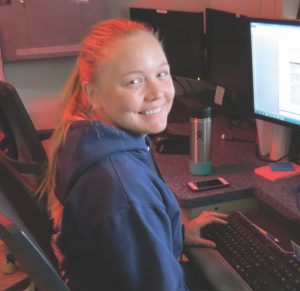
- Hydrographic Surveyor – NOAA
- Hydrographic Senior Survey Technician
- Alaska
- Currently serving on a multi-year stint aboard the Fairweather, a research ship of the U.S. National Oceanic and Atmospheric Administration, Ali is involved in many aspects of collecting the data and generating bathymetric models that will be used to make updated nautical charts and inform various scientific research teams. Hydrography and hydrographic surveying can be an exciting field that takes one to far reaches of the globe and can see firsthand the awesomeness of natural phenomena. If you know of young folks considering geospatial careers who love the outdoors, have an interest in the environment, and are looking for adventure, be sure to include discussions (and maybe go talk to folks involved in) hydrographic and marine surveying.
Merve Keskin 
- Geomatics Engineer & Cartographer – Antea Group
- PhD candidate and researcher – Ghent University
- FIG Young Surveyors
- Belgium
- Merve is a PhD candidate and researcher at Ghent University – an internationally renowned education and research center. Her current research is looking at how people look at maps, how we interpret maps based on how they are presented, and looking at the granular details, like studying eye tracking while people look at maps. Mapping and cartography are in the midst of a new renaissance, with not only more amazing tools for creating maps but also in how maps can effectively represent much more geospatial data than ever before. But how well can we utilize maps? The research of Merve and others will help inform nature and design of the “new geo.”
Sami Ullah Khan 
- GIS & Remote Sensing Manager – The Urban Unit
- GIS manager, trainer
- Member, Survey of Pakistan
- Pakistan
- Sami has proven his leadership qualities, delivering a rapid growth rate for the Urban Unit, one of the major GIS entities in his country that is undergoing tremendous infrastructure, land administration, and natural resource management development. Published in matters of GIS and remote sensing (eight papers), Sami is also a geospatial trainer and member of the Survey of Pakistan.
Melodi King 
- Owner and Cartographic Engineer – Smallmelo GIS
- Geospatial community advocacy, outreach, volunteering
- New Mexico
- There is a mini-boom going on in cartography: small and medium sized mapping specialty firms, and Melodi “Melo” King is a splendid example. She supports all manner of mapping services, mixing tech to gather, analyze and visualize spatial data, but while maintaining excellence in cartographic presentation. While her bachelors degree is in chemical engineering, other studies have included programming, digital illustration, and she is a certified UAS pilot. Her master in geographic information science is from the University of Redlands (hometown of Esri). Melodi is quite involved in volunteering, such as her work with Code for ABQ, a group of volunteers building tools with local government.
Ferah Pırlanta Köksal 
-
Community Lead at HERE Technologies
-
Geomatics Engineer
-
Turkish Chamber of Survey and Cadastre Engineers
-
FIG Young Surveyors Network
-
Council of European Geodetic Surveyors (CLGE)
-
Turkey
Ferah is a geomatics engineer with both a bachelors and masters from Istanbul Technical University. She worked at several different jobs as an engineer in relation to remote sensing, GIS, and land surveying. She was the head of the organization committee of the International Geodetic Student Meeting 2014 Istanbul. Ferah is a member of International Relations Committee of Turkish Chamber of Survey and Cadastre Engineers. She is active in outreach for the geomatics and geospatial communities and has served in multiple roles for the FIG Young Surveyors. She is also a member of the executive board of Council of European Geodetic Surveyors (CLGE) as a representative of FIG Young Surveyors European Network. She is working as a Senior Community Lead at HERE Technologies. Ferah is providing leadership in outreach to the geo-community, and broader communities to recognize the value and benefits new technologies using location-based services. She also has a passion for music and working at college radio station called ITU Radio Rock since 2011.
Drummond Community School 
- DEC Hyperloop Challenge winners:
- Alizah Mughal, Ryan Gordon, Faye Fulton, and Wiktor Rauba
- Scotland
- In 2019, the Bentley Institute and Class of Your Own (COYO) hosted the first ever Future Infrastructure Challenge, DEC Hyperloop challenge, in London. The event included students from schools in the UK whose assignment was to conceptualize a design of a hyperloop transport system and stations for their own towns, and, for the final competition, to adapt a design for Singapore. Students from Drummond Community High School from Edinburgh, who benefited from 3 – 4 years of COYO curriculum (including surveying elements) won the challenge and were awarded a complimentary trip from Bentley to attend its Year in Infrastructure (YII) Conference, held October 2019 in Singapore. xyHt met this team at YII and we were impressed with not only their technical savvy but the wisdom beyond their years they exhibit, their politeness, excellent presentation skills, environmental awareness, and optimism for the future of AEC.
Tobias Kraft 
- Founder and CEO – SolSpec Aerial
- Analytics for energy, environmental, and large-scale land use
- Colorado
- With deep roots in environmental science, Toby cut his teeth as a GIS Analysts using drones and precision ag technology to improve vegetation management on oil and gas facilities. His thirst for using new technology to influence critical decisions didn’t stop there. In 2017 Tobias left his position at Duraroot, an environmental consulting firm, to start SolSpec where he could assemble a team of like-minded individuals focused on the discovery of industry pain points and developing cost-saving solutions. Tobias says, “We don’t start by building the best technology and waiting to see how the market responds. We find the problems and build the best technology to solve them.” Today, SolSpec specializes in the processing and analysis of photogrammetry and lidar data from unmanned aerial vehicles, manned aircraft, and satellite systems. The company has developed a secure cloud-based geo-processing platform and propriety analytics models based on analysis of over 2 million acres of pipeline right-of-way projects to create high-resolution 2D and 3D models for comprehensively visualizing and quantifying risk to pipeline safety by measuring changing conditions, hydrology, erosion control, and slip potential. Purpose-built analytics and models enable pipeline operators and owners to transition from reactive disaster management to proactive pipeline integrity management – using data and analytics to protect the safety of their employees and people living along pipelines, protect the environment, and to improve operational efficiencies.
Jordan Lawver 
- Mixed Reality Portfolio Manager – Trimble Geomatics
- Engineering, GNSS, computer vision & photogrammetry
- Colorado
- Yes, virtual (VR), augmented (VR), and mixed/extended reality (XR) will, and are having an impact on AEC; geomatics, digital construction, inspection, and operations. The solutions have gone from cool demos to applications in real-world projects. We got to get to know Jordan at the Mobile World Conference in early 20219, where Microsoft announced HoloLens 2, and Trimble announced their hardhat-ready version, the XR10. Jordan is portfolio manager of that and other mixed reality products. He is handling is role, shepherding what is in many ways a new frontier, quite well with a very positive and optimistic outlook. And, as we’ve observed, is having a lot of fun doing so. Jordan earned his bachelors in geomatics engineering, and masters in computer vision and photogrammetry from Ohio State University.
Aaron Leach 
- Survey Manager, Rowe Professional Services
- Surveyor of the Year, South Carolina Society of Prof. Surveyors
- South Carolina
- Aaron was recognized by the South Carolina Society of Professional Surveyors (SCSPLS) due to his commitment to promoting the industry and his outreach to the next generation of surveyors. He is also the current president of the SCSPLS. His volunteerism includes speaking at local schools as part of the Trig*Star program, which is a high school initiative that promotes the study of trigonometry and builds awareness of the surveying profession among mathematically-skilled high school students, career guidance counselors, and math teachers.
Candace MacDonald 
- Geographic Information Systems Technician – Wood
- President, Geomatics Association of Nova Scotia
- Canada
- Candace came to our attention from papers she has authored/co-authored on subjects ranging from GPS validation of lidar elevation models, to impervious surface mapping for the Canadian Province of Nova Scotia, namesake for the geomatics association she is currently president of. The Geomatics Association of Nova Scotia (GANS)has quite a few members that are quite active in geospatial publishing, geo-social-media, and there are several nationally and internationally renowned geospatial academic programs in this maritime province. Nova Scotia, and Canada as a whole seem to have particularly embraced the value of geospatial, producing many fine leaders in the geo-community, like Candace. Her degree is in biology and geology, an advanced diploma in GIS and remote sensing, and has over a decade experience as a research assistant, GIS technologist and technician.
Massimo Marra 
- Surveyor, ENEL
- Topographic, Engineering, Geology, Energy sector: gas, wind, solar
- Italy
- Massimo found, early in his surveying career, that he truly loved this vocation and went on to earn a second certification. The field of utility and energy surveying has provided fresh challenges and adventures, and Massimo is a fine example of the dedicated and energetic young practitioners. While many in the surveying profession might look at energy and utility surveying as more of an adjunct to engineering, this might be a disservice to the skill and dedication of those meeting these surveying needs, globally, for infrastructure and emerging energy resources. This is a booming field.
Brooke E. Marston 
- Cartographer – Department of State
- Outreach, volunteering
- District of Columbia
- Brooke is the editor of the North American Cartographic Information Society’s (NACIS) Atlas of Design. She has an M.S. degree in Geography from Oregon State University, a B.A. degree in Geography, and a B.M. degree in Music Performance from the University of Colorado at Boulder. Her OSU research profile: “Ms. Marston’s research interests are in terrain visualization and manual and analytical relief shading. In her research, Ms. Marston [worked] to develop new digital shading methods and algorithms to generate shaded relief images according to the manual cartographic principles of Swiss-style relief shading. The goal of Ms. Marston’s research is to better portray terrain through the local adjustment of brightness and illumination.” Her work has been featured in the National Geographic Atlas of National Parks.
Taryn Martin 
- Licensed Cadastral Surveyor – BTW Company Ltd
- Survey and Spatial New Zealand Young Surveyor Award
- New Zealand
- Whether hiking in to the Everest basecamp, organizing and guiding global adventures, surveying in the field, or out on the rugby field, Taryn continually impresses his peers with his tenacity, skills, and dedication. He was recognized by Surveying and Spatial New Zealand with a young surveyors award. A licensed cadastral surveyor, Taryn is also director at Experience Earth Travel, an agency for guided and unguided treks and hikes all over the globe. He studied surveying at the University of Otago, where he earned his bachelor of surveying (BSurv) with credit in land surveying, spatial sciences, land development, GIS, and planning.
Merylene Naidoo 
- Surveying Engineer – eThekwini Municipality Project
- Leadership, outreach, tutoring
- South Africa
- With both a national diploma and bachelor of engineering surveying, Merylene added a post-graduate diploma in project management. With a decade of public and private sector surveying and team leadership roles of increasing in responsibility, she is well respected in the geomatics community in South Africa. Merylene is also active in professional and industry events.
Ananya Narain 
- Research Project Leader & Strategy Consultant – Geospatial Media Geospatial
- Head-AEC Business Unit.
- Policy & market intelligence. European Commission expert
- India
- Studying trends in geospatial industries and professions they support is increasingly complex. Development and adoption cycles are often much shorter than ever before. The sheer scale of infrastructure development, GIS utilization, geomatics technological innovation, new fields, managing and processing “petabytes” of geospatial and remote sensing data: these all contribute to dynamics that defy conventional studies and reports. But, Ananya Narian has been deeply involved in the research and authoring of annual and ad hoc reports that have become essential reading and study for leaders and practitioners in the global geospatial community. Ananya is the Head-AEC Business Unit, Geospatial Media and Communications, based in India. With a background in Economics from the University of Delhi, International Business and Finance from the Henley Business School and a Management program from London School of Economics, she stepped into the field of Geospatial by being actively involved in understanding and analyzing the global geospatial market, the global BIM market and other latest technology innovations. Also enrolled as an expert with the European Commission, Ananya, has a substantial work experience with the public and the private sector, in helping them assess their geospatial preparedness and conducting geospatial market evaluations. Ananya now conducts analysis and research in the field of Geospatial + BIM and works actively for technology advocacy via reports, news articles, etc., with the intent of enhancing knowledge uptake of policies, processes and practices of geospatial solutions in critical economic industries and geographies. One of her core strengths is the Countries Geospatial Readiness Index – a part of the GeoBuiz Report wherein 75 countries are ranked for their geospatial preparedness. She also writes extensively about ConTech, Subsurface infrastructure, geospatial readiness, policy advocacy, and sustainable development goals, some of which can be accessed here: https://www.geospatialworld.net/author/ananya-narain/
Hannah Pearce 
- Graduate Surveyor – MMB Surveyors
- Student ambassador for University of New South Wales engineering programs
- Australia
- Quoting the award announcement from the University of New South Wales: “Hannah Pearce has won the NSW Excellence in Surveying and Spatial Information University student of the year award for 2018. This award recognizes the best undergraduate thesis project from all students in surveying degrees across NSW. Hannah’s thesis analyzed a new method for calibrating a total station (common surveying instrument) without a known baseline (the traditional method used by surveyors). The strengths and limitations of this method were analyzed, and improvements to increase redundancy and provide an indication of the error in the estimation were presented. She also looked at the Topological Grid Search (TGS) method of adjusting survey networks, again a new innovative method. Finally, Hannah provided a step-by-step explanation of the Simultaneous Localization and Mapping (SLAM) process, nowadays used widely in mobile laser scanning. SLAM relies upon an Extended Kalman Filter (EKF), and this thesis steps through the mathematics of the EKF, comparing it to the Least Squares adjustments with which most surveyors are familiar. Overall, this thesis was recognized as a significant and technically challenging contribution. This award is the culmination of a very successful academic career at UNSW where in 2018 Hannah was the recipient of the Institution of Surveyors NSW Inc. Prize as the best in her final year class. Previously in 2016 she won the Maurice Maughan Prize for survey computations and the George Bennett Millennium Prize for the best performance in all Year 1 courses in 2014. Hannah is also a past-president of the UNSW Student Surveying Society. All of the surveying academics who were lucky enough to have had Hannah in their classes would like to extend their hearty congratulations.”
Will Richardson 
- Partner – Edward Cooper Young – Chartered Surveyors CLC
- Construction Leaders Club Rising Star
- United Kingdom
- As a chartered surveyor, specializing in the field of quantity surveying, Will has been recognized as rising star and was been shortlisted for the (Royal Institute of Chartered Surveyors) RICS Matrics UK Young Surveyor of the Year award. Will has been quite active in professional associations, including RICS; he served as the chairman of the Leicestershire and Rutland Matrics Committee. Will studied international business at the Nottingham Trent University where he would go on to earning his masters in quantity surveying.
Dave Robinson 
- Senior Licensed Cadastral Surveyor – Aurecon
- 2019 Survey and Spatial New Zealand, Bogle Young Surveyor of the Year
- New Zealand
- Dave was awarded the Percy Dyett award for the best overall land development engineering project and interview in the National Professional Entrance Examinations for 2019. These entrance examinations cover a number of competencies and are the final step in the process to becoming a Licensed Cadastral Surveyor in New Zealand. The award was established from a legacy from the estate of Henry Lewis Percy Dyett, a member of the Survey Board for many years. The award is intended to encourage a greater interest and all-round knowledge of engineering and to encourage candidates to professionally present themselves and their project to the Survey and Spatial New Zealand Admissions Panel.
Ruth Lailany Trujillo Rodríguez, PS, PPL, PIC 
- President, Ruth L. Trujillo Rodriguez Professional Land Surveyors, PSC
- Past President, Institute of Land Surveyors (CIAPR)
- NSPS Delegate Asociación Panamericana de Profesionales de Agrimensura y Topografía (APPAT)
- Puerto Rico
- Ruth has been described by her nominators as dynamic and exhibiting boundless energy, both as founder of her own surveying firm and with her many roles in professional associations. Ruth L. Trujillo Rodriguez Professional Land Surveyors is the only Hispanic woman-owned surveying and mapping firm established in Puerto Rico, and it offers a full range of services from boundary, to UAS, to construction surveying. Ruth has served as a planning analyst, project surveyor, and professor for the master’s degree program in geospatial science and technology for the Polytechnic University of Puerto Rico. In addition she is a regional delegate to the National Society of Professional Surveyors and is active with both the FIG and NSPS Young Surveyors networks.
Margaret Spyker, GISP, LEED 
- GA Data Scientist & GIS Analyst
- Board member, International Map Industry Association
- Colorado
- Margaret is a project team leader and data scientist who is experienced in the the full life cycle of geospatial data: in field data collection, processing and analysis, all the way though to visualization. She holds a GISP, and a Leadership in Energy and Environmental Design Green Associate (LEED GA) certification. Always active in the geo community, she is a board member of the IMIA. Margaret spent 4 years at a GIS Research center at Western Michigan University in detailed cartography, visualizations, GIS data processing and has received awards for team on individual research. Margaret earned her masters in geography from Western Michigan University where she also served as a teaching assistant and instructor.
Saumya Thakur 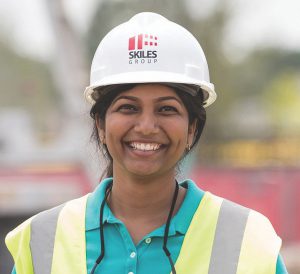
- Assistant Project Manager – Skiles Group Construction
- Management, civil engineering, outreach & volunteering
- Texas
- Saumya earned her degree in civil engineering at SRM Institute of Science and Technology in Chennai, and then attended Texas A&M for her masters in construction management. Growing in her experience in the emerging world of digital construction, Saumya has always given back her community as well the geo-community, volunteering, tutoring, and organizing. Examples include Initiate Fusion, a social drive that was started by the students of SRM University, to help under-privileged children and students by donating books and stationary. In Texas, she volunteered on an initiative to help preserve and beautify the Brazos River.
Tara Tibshirani 
- GIS Technician – Natural Resources Canada
- Geospatial writer, outreach, volunteering
- Canada
- The geospatial community needs effective voices for outreach and to chronicle the professions and the industries that support them. Tara came to our attention for her writings for and online geomatics publication we admire from Canada: GeoGeomatics. An example of her writing we particularity enjoyed is “10 Canadian Border Disputes that Shaped our Country.” Tara earned her degree in physical geography from Carleton University.
Igor Vereninov 
- Co-Founder & Co-Owner – Emlid
- Published researcher, developer, and GNSS entrepreneur
- Russia
- Igor has a bachelor’s degree in applied mathematics and mechanics and a master’s degree in mathematical modeling at the Peter the Great St. Petersburg Polytechnic University, and his interest in UAVs sparked an idea. He used to lead a team performing R&D and custom integration projects for one of the leading UAVs manufacturers in Russia, but now Igor Vereninov is a CEO and co-founder at Emlid. At Emlid, Igor and his co-founders set out to make centimeter-accurate RTK GNSS receivers that are modern, affordable, and easy to use for not only UAVs but now for surveying, mapping, and other applications. It all started with a crowdfunding project through Indiegogo. The campaign raised 303% of required funds, and this allowed launching the first batch of GNSS receivers. Now Emlid is selling products worldwide and employs 50 people.
Anthony Whitlock, PLS
- Land Surveyor – Colorado Springs Utilities
- Surveying writer and photographer
- Colorado
- The surveying profession needs fresh new voices, essayists, writers and presenters. xyHt has been proud of our efforts to find, foster, and publish new writers. Anthony joins the ranks of new surveying writers (and some have been 40 under 40 honorees) Adam Thayer, Heidi Jackson, Marc Delgado, Nick Bearman, James Nicolau, Eva Maria Unger, and more. Anthony is one of the emerging voices for the profession and he is a skilled photographer; his photos capturing field surveying scenes (and stunning Rocky Mountain vistas) are regularly featured in surveying social media. Some of his writings include “A Millennial’s View of Land Surveying,” “Construction Staking,” and a two-part treatise “Understanding GNSS.”
Ian C. Wisuri, PLS 
- Associate – Beals and Thomas, Inc.
- Surveyor of the Year, Massachusetts Assoc. of Land Surveyors & Civil Engineers
- Massachusetts
- Surveying professional associations and societies, at local, state, national, and international levels would not exist without the tireless dedication of volunteers, and we are honored to present several such fine examples in each year’s 40 under 40. Ian earned his surveyor of the year award for his dedication to the professional and the state association. He has served as an instructor for association courses, as secretary, and helped organize multiple conferences and events. After attending Worcester Polytechnic, Ian added an associates in surveying from the University of Massachusetts (Lowell). He has worked as a survey project manager and is now an associate with the engineering consultation firm Beals and Thomas.
Nick Zhu 
- Sales Director – Tersus GNSS Inc.
- Studied geodesy & surveying
- Launching a new GNSS line to global markets
- China
- The plan was quite ambitious for a GNSS startup, and especially for this relatively new company based in Shanghai (and Australia): to eschew the giant domestic market in China and concentrate mainly on international markets—emerging and established. What’s more, Tersus GNSS has been developing its own GNSS boards that take full advantage of the full range of GNSS constellations. But successful they have been, and in a few short years have established an excellent reputation and launched some high preforming yet affordable survey rovers. A lot of the success can be attributed to this dynamic young fellow. What brought Nick to our attention is how effective he has been in presenting his company’s message to an international audience; one of the most impressive leveraging of geo-social-media we have seen in the industry. Nick has a bachelors in urban management, a masters in engineering surveying specializing in advanced satellite positioning, geodetic reference systems, geodesy, remote sensing, and has done stints as a researcher. His current role is in sales, where he keeps geomatics science at the heart of marketing outreach.
St. Patrick’s School 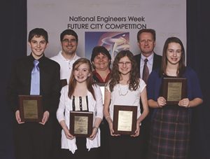
- Best Land Surveying Practices Award Future City Competition, NCEES
- St. Patrick’s Catholic School
- Washington
- Among the annual student competitions hosted by the National Council of Examiners for Engineering & Surveying (NCEES) is the Future Cities Competition. 33,000 middle school students from across the U.S. participate with 35 regional winning teams in the finals. The team for St. Patrick’s School, in the Tri-Cities region of eastern Washington State, took the award for best surveying practices, as applied to their submitted project. For nearly two decades, the Future City Competition has been one of the highlights of National Engineers Week. Aimed at students in grades 6–8, the program is designed to spark interest in math, science, and engineering. Teams feature students working with teachers and volunteer engineer mentors to design models, using both computer software and physical materials, of their vision of a future city based on a given theme.
Know an outstanding young professional or school team under 40 you’d like to see nominated for 2021? Email us: 40under40@xyht.com