All posts by Alvan Karlin

What to do With All the Lidar Data
An age-old Aesop’s Fable adage says, “Be careful what you wish for, lest it come true!” When the U.S. Geological Survey (USGS) embarked on the National Enhanced Elevation Assessment (NEAA) in 2012, the goal was to document the national-level requirements for enhanced elevation data. Little did USGS know at the time, the report would be...
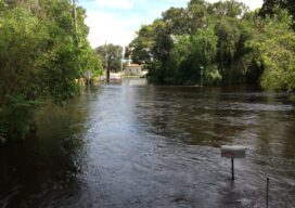
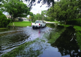
Managing Tropical Storm Risk in Florida
Low-lying Gulf Coast communities along the Anclote River in Pasco County, Florida, have a long history of summer flooding. In 2012, after Tropical Storm Debby brought more than 12 inches of rain in a 24-hour period to the Tampa Bay area, the residents of the Thousand Oaks subdivision in the Trinity community experienced widespread, long-lasting...
Lidar for Floodplain Models: A Project in Florida
Florida’s topology data gets a needed update with a massive project based on lidar data. Three major hurricanes (Category 4 and above) passed through the Caribbean and the Gulf of Mexico during the 2017 hurricane season—Harvey, Maria, and Irma—and they were three of the five costliest hurricanes in the United States’ history. Hurricane Irma, for...