All posts by Charles D. Ghilani
Where Theory Meets Practice: SPCS Zone Conversions
Whether you learn fundamentals of surveying from a formal degree program, certificate program, CEU seminars and workshops, self-study, or in-the-field training, you feel a certain delight in that moment of discovery when the theoretical has met the practical. These moments come when (what first appear to be) dry mathematical or legal principles taught in the...
Where Theory Meets Practice: Determining Your State’s Next SPCS Zone
In the 1930s when the National Geodetic Survey (NGS), formerly the Coast and Geodetic Survey, created the first state plane coordinate system (SPCS), they limited the precision between a geodetic (ellipsoid) distance and the map distance to a precision of 1:10,000 or better by limiting the width of the zones. This resulted in many states with multiple...
Where Theory Meets Practice: Defining Surfaces
The Earth is composed of several physical and mathematical surfaces that play important roles in surveying. As shown in green in Figure 1, the surface that we are most familiar with is the topographic surface. This is the top layer of the Earth that most people spend their entire life on. It is the surface on...
Single Transformation with ECEF
We at xyHt think this topic is one surveyors should be talking about. Instead of placing this reader’s letter to us as a comment under Dr. Ghilani’s article (linked below), we are making it a post itself to encourage discussion underneath. Editor Gavin Schrock, PLS, started us off, below. Professor Ghiliani’s article, Transformation of Observations...
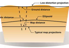
Where Theory Meets Practice: Grid versus Ground
In this article, I demonstrate the proper computations used when working with conventional surveys that use state plane coordinates. I purposefully selected a traverse in Pennsylvania that climbs about 1100 ft in its 2-mi length. By examining this particular site as an example, the reader can see the effects of elevation on the computations and...
Where Theory Meets Practice: The Geiod and Leveling
As mentioned previously in this column, the geoid is the equipotential gravitational surface on which all elevations are referenced. An equipotential surface is where the force times distance is a constant. Gravity provides the force, and the distance is the height above this surface defined along the plumb line of an instrument. As shown in Figure...