All posts by Gavin Schrock
ROPOS: ROV Cool
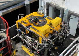
I recently accompanied a film crew working on a documentary on maritime technologies to the NOAA facility in Newport, Oregon to catch a glimpse of what is widely celebrated as the “coolest ROV in the world.” The Remotely Operated Platform for Ocean Sciences (ROPOS) is the flagship research ROV of the Canadian Scientific Submersible Facility...
Open Source
The door to open source geospatial software has been unlocked. It’s time to take a peek inside. The open source geospatial movement is not purely about “free” (as in no cost). There truly are other aspects of “free,” as in “free to develop without constraints,” and free access to public geodata without necessarily having...
What is xyHt?
Stand in the place where you live Now face North Think about direction Wonder why you haven’t before “Stand” – R.E.M. Why an obscure geodetic expression? It’s not all that obscure—it represents a foundational element requisite to nearly all human endeavor. It touches your life explicitly and in the abstract. All of the ways that...

An Interview with Ken Jennings
An Interview with Ken Jennings: Speaker, Author, Geographer

It’s About Time
Australia tech-rebel company Locata is poised to profoundly change the world of positioning, navigation, and timing. In 1994 in Canberra, Australia, accomplished musician and entrepreneur Nunzio Gambale was introduced to a fellow musician, David Small, by Gambale’s cousin who had been giving Small a hand with an interesting experiment. This chance meeting began an amazing partnership in technological development. The scenic capital territory of Australia has its fair...
Dr. Mark Monmonier on Modern Cartography
“I’ve heard people say that cartography is dead. Where might that kind of thinking be coming from?” I asked Dr. Monmonier, distinguished author and professor of geography at Syracuse University. His response was, “Why would anyone in his or her right mind think cartography is, or might be, dead?” This initiated a discussion about people...