Engaging citizens to participate actively in urban development projects can often be difficult. But rendering designs in 3D city models and transforming them into immersive virtual reality spaces might just do the trick.
When it comes to reshaping cities and constructing new structures, modern architects consider public participation an essential part of creating sustainable and livable areas.
From Sweden to Singapore, more and more places are shifting away from the traditional top-down approaches in urban planning and are now embracing civic engagement. Yet even the most well-intentioned urban changes can leave many people behind, especially when citizen involvement falls short.
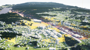
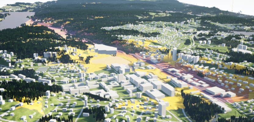
A portion of Gothenburg 3D city model created by the Digital Twin City Centre (DTCC) at Chalmers University of Technology in Gothenburg, Sweden.
Take for example the conventional way of presenting design proposals to the public. Urban planners normally employ 2D drawings as well as paper cut-out 3D scale models to help citizens visualize how new urban projects will impact their landscape. Due to the nature of their jobs, urban planners are very skillful in imagining these diagrams in bigger and true-to-life dimensions.
But to the untrained eyes of the citizenry, it may be more difficult to perceive and derive insights from simply looking at printed maps, paper drawings, or model cut-outs. This basic spatial limitation is one important factor that reduces the effectiveness of public participation in the urban design process.
So how can we improve citizen engagement in urban development projects and make the experience less passive? Several digital tools are already being used around the world, such as GIS maps and 3D city models. These mapping platforms can be viewed on wide computer screens or projected on large walls to make them seem life-like, a typical solution that is being employed in many town hall presentations.
Yet they also fall flat in terms of interaction because merely displaying the Earth’s curved and uneven surface on a screen, however big the screen is, will still distort how reality is perceived by a normal person. Putting that person inside the map could be a better alternative.
That’s what virtual reality (VR) technology is doing. VR can simulate real environments by placing the users within the context of any design project using 3D-rendering VR headset devices. By wearing a VR headset, anyone can have the opportunity to experience the envisioned design in an immersive environment, allowing them to have a richer interaction with the project before it is built.
With virtual reality technology, planners can convey their urban design projects in a simulated manner where people can walk through a map or a master plan, view and understand the proposed construction in their exact dimensions and topology, and have an interactive experience with the future building or landscape. The viewer’s instantaneous interaction with the design can then offer important feedback that can be used to improve or modify it.
One such project that aims to make virtual reality a useful tool in urban planning is Twinable, a research activity that is part of the Digital Twin City Centre (DTCC) at Chalmers University of Technology in Gothenburg, Sweden. Twinable is using the 3D model of Gothenburg, the city’s digital twin, which was created by the DTCC to support large-scale urban simulations and visualizations.
“Digital twins are becoming more and more available but are still quite abstract for most people,” says Alexander Hollberg, an associate professor for Computational Sustainable Design at Chalmers and also an architectural engineer by training.
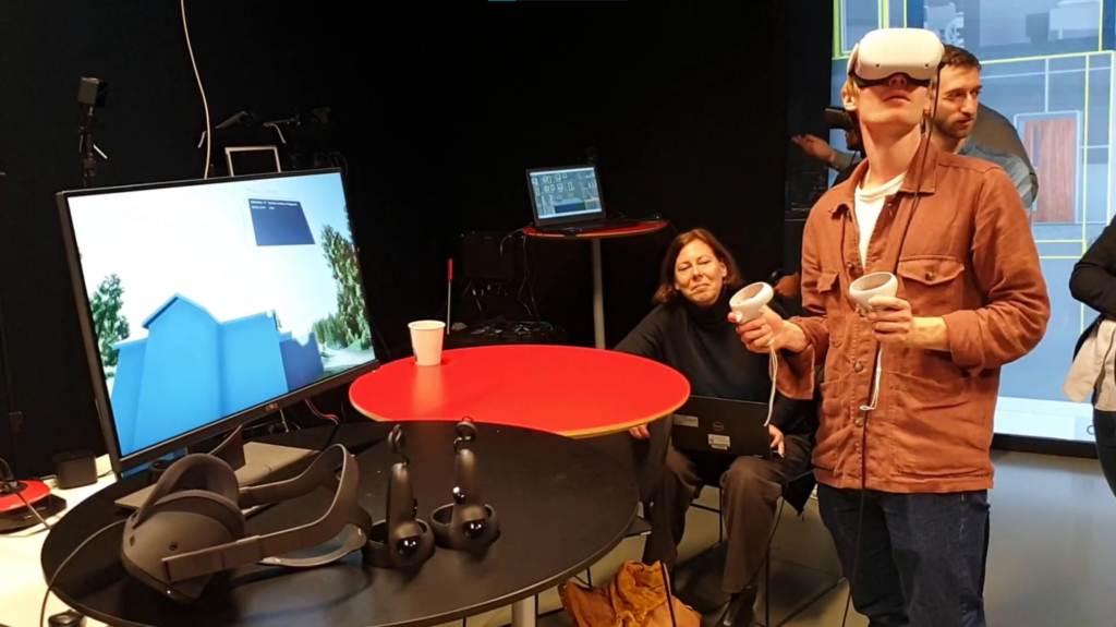
A participant wearing a VR headset and holding its controller while taking part in Twinable’s Virtual Reality project.
“The same is true with other digital technologies, such as virtual reality and augmented reality, which are also becoming more available but are not yet that readily usable for everyone,” adds Hollberg, who along with colleague Liane Thuvander want to make use of these new technologies as a “way to understand and explore how digital twins of cities can be made accessible to researchers, designers, and the general public.”
Thuvander, an architect and professor in Architecture and Sustainable Building at Chalmers, and Hollberg lead the Twinable project.
“In my research, I study how digital tools can support stakeholder dialogue and participatory processes in planning, design, and transformation of the built environment,” says Thuvander.
Hollberg and Thuvander had a perfect case study to test their virtual idea. In the outskirts of Gothenburg, there is a plan to construct a new town for 10,000 inhabitants in an area that today is dense forest. As was anticipated, many people objected to the plan, so the project developers wanted to show that there will still be a lot of trees in the new town while also allowing the citizens to participate in the planning process.
“For this project, our virtual reality platform has been developed with a focus on efficient and realistic visualization of the forest and vegetation in order to show how the future urban development will look like,” says Thuvander. “This includes visualizing new buildings and their potential impacts on recreation areas. But most importantly, the VR platform is envisioned to invite the residents to give feedback on the development, as well as to interact and comment on the proposals.”
Hollberg believes that although one can try to convince citizens with maps and presentations, there is a better alternative. “Letting people explore the new town by themselves in VR is much more powerful,” he says.
Virtual reality has been around for many years, and it has very strong roots in the video gaming industry. Gamers have been enjoying immersive gaming experiences since the release of commercial VR headsets by companies such as Oculus, Sony, and Nintendo in the mid-2010s. Back then, some of the very-first VR games like Arkham and Final Fantasy XV, were slow and lagged a lot. But they already looked great due to the enhanced realism of the game’s surroundings.
Despite the latency and technical glitches, virtual reality gaming increasingly became popular because it provided gamers with better visual sensory stimuli and promoted active play interaction like never before.
So maybe the Twinable team members are virtual reality gamers themselves?
“No, we are not VR gamers at all,” says Hollberg. “Actually, I have never used a VR headset before this project.”
Hollberg, however, thinks that it sometimes helps to have an outsider perspective while doing research. He explains that when he joined the DTCC and met all the mathematicians and computer scientists who were developing the digital twin city platform, he was amazed by their work. And yet he thought something was missing.
“This new technology needs to be understandable to ordinary people like me. Personally, I need to see something to be able to understand it, and I assume that many people are the same,” says Hollberg. “So, I thought, why not try to allow others to see both the new design proposals and the power of the digital twin platform in the virtual world? I knew that Liane was experienced with participation studies, while at the same time VR headsets have become much cheaper. And other colleagues had the computational skills. So, I was convinced this should work.”
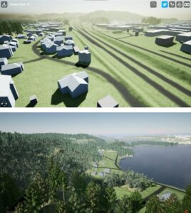
Two virtual reality scenes show buildings, landscapes, and almost real-life depictions of vegetation of a plan to construct a new town for 10,000 inhabitants in an area that today is dense forest in Sweden.
One of those colleagues is Sanjay Somanath, a PhD student at Chalmers whose research looks at how digital tools can support architects and urban planners with social sustainability. “For the Twinable project, my role was to build the pipeline combining real-world data from different sources and getting them into Unreal Engine,” he says.
Unreal Engine (UE) is a powerful 3D computer-graphics design software developed by Epic Games, an American video game company best known for the game Fortnite. UE is an example of a low-code game engine that allows people with basic programming skills to develop three-dimensional features of buildings and landscapes from scratch using the software’s own Visual Scripting system. Since 2015, the UE platform has been made available to anyone at no cost, a boon not only to game developers but also to architects and computational designers like Somanath.
“To be honest, I can’t imagine another way we would be able to achieve our project,” replies Somanath when asked about how the 3D computer graphics game engine was beneficial to create the immersive environment that they needed.
“We are not professional game developers or programmers, but platforms like Unreal Engine have democratized this way of visual communication that is otherwise inaccessible to a lot of people,” says Somanath. “I think that this is a really powerful thing.”
The Twinable team also had to access other geospatial files to build the 3D virtual city model of their study area. For instance, they tapped the open mapping dataset of Gothenburg and processed it on the DTCC platform.
“The Lantmäteriet (the Swedish mapping, cadastral, and land registration authority) was our main source of real-world data,” says Somanath. “We used the DTCC platform to generate a JSON representation of the existing buildings and their attributes so that we could then visualize them in Unreal Engine.”
The team was also able to make use of other valuable datasets from the transport, urban development, and forestry departments. “These provided as much detail to our VR project as possible,” adds Somanath.
And indeed, a quick view of their simulated landscape shows realistic-looking trees and foliage, evident of the meticulous work that was put into their VR environment.
But not everything was a walk in the virtual park. Somanath says one of the hardest parts of their work was bringing together all the different datasets. “We had GIS data on the various land uses, species of trees and plants as boundary regions, as well as lidar scans of the area,” he says. “But we had to determine which regions had what vegetation and how to communicate all that to Unreal Engine.”
In the end, the solution that they settled on was to compress all this geospatial information into raster masks. “This is a technique that game developers have been using for a long time, but it was new to us,” says Somanath. “Once we could do that, Unreal Engine did much of the heavy lifting. We used the world composition and procedural foliage spawner inside Unreal Engine to manage the millions of trees that went into the forests.”
Anyone with experience in creating landscapes, may it be with maps or 3D city models, will always look at the level of detail of each element as an important factor to consider in visualizing simulated places. The same is also true in making virtual reality scenes.

The Twinable Team (from left to right): Alexander Hollberg, Liane Thuvander, and Sanjay Somanath.
“Getting the level of detail (LoD) just right was a challenge because we wanted users to have an immersive experience and really get a feel for the nature and the scale of the forests, while still being able to run our VR platform on a regular laptop,” says Somanath. “This required a lot of tweaking on the foliage assets that we used. In the end, we manually went into each LoD of the foliage assets and optimized them so users wouldn’t be pulled out of the experience.”
Once the VR platform was ready, the Twinable team invited two groups of participants to test it. The first group was composed of professionals (architects, software developers, consultants, urban developers, municipal officers), and the second group was 15-year-old students.
Donning an Oculus Quest VR headset, the participants walked and interacted with the VR scenes, while the Twinable team observed their behavior throughout the process. Afterward, the participants were interviewed to get to know how they perceived the virtual landscape and vegetation, as well as how they navigated and interacted within the VR environment.
Judging from the answers of the participants, Thuvander observed that the virtual reality experience was a bit different for the two groups.
“Generally, both the professionals and the students were enthusiastic to use VR,” says Thuvander. “But it was more straightforward for the students as they are more used to gaming and moving around in virtual environments. As soon as the students wore the headsets, they started directly to explore the functions and different settings and helped each other when getting stuck. They played around quite independently,” she says. “The professionals, however, had a longer starting process to get familiar with the VR equipment and its functionalities. We needed to help them from time to time.”
So, what did the participants think about the urban development project as it was rendered in VR?
“The participants appreciated the high level of detail of the trees, especially as the leaves moved in the wind. Also, most users would have liked more details on the buildings,” says Hollberg. “The students, on the other hand, had lots of fun exploring the virtual buildings, moving them to other places and proposing new amenities, such as an ice rink or shopping mall, which they would like to put in place.”
According to Thuvander both the adult and student groups showed interest to continue using the VR platform, although she adds that “we still have to improve the VR’s usability.” She explains that this can be done by developing more functionalities, as well as adding additional details about the buildings, and making users move more smoothly in the VR environment.
“In the future, we would like to do more tests with different user groups and work with comparable versions of the content with focus on interactivity,” she says.
While their Twinable project is still on-going, and with upcoming improvements in mind, Thuvander already anticipates that there is an important sector that will surely value their VR efforts.
“We see architects as one group of professionals who can benefit from using VR and digital twins. VR can provide a rich level of detail in an immersive environment, it is interactive, and you can move around,” she says. “VR can convey a better feeling of the future places and can support the architect’s communication with clients. This way clients might feel more involved in the process. Aside from that, a more realistic VR can also help the architect’s own design process as it can visualize the consequences of different design solutions.”
While the Twinable team acknowledges that more work needs to be done, they are also quite optimistic on the role that digital twins, 3D city models, and virtual reality can play in making urban planning more interactive.
For Hollberg, the main advantage of these new digital tools is the way they make data more easily accessible for urban planners. “It provides a platform to test, simulate and optimize various scenarios,” he says.
Thuvander agrees and sums it up by stating that digital twins can make complex data understandable to the public in support of civic engagement. “Through digital twins, data can be collected about the perception and opinions from the public in a participatory way,” she says. “This will allow citizens to be actively involved in the planning, design, and transformation of their own neighborhoods and city.”