All posts by Gavin Schrock
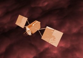
The FCC 5G vs GPS Stinkbomb
Op-Ed: No, 5G is not spreading a virus, but one new 5G implementation could harm GPS— and people rely on GPS far more than they realize. Note: This post is NOT anti-5G. There is plenty of room for 5G expansion in other spectrum besides that in which GPS resides. The 5G card has been played in...

Another Curveball: Coronavirus and Geospatial
Out of the blue, we’re facing another curveball. The current global concern (COVID-19, aka the Coronavirus) was generally not anticipated, and the situation changes daily. It was hoped that, by the time this is published, the situation would have calmed dramatically—but sadly it has taken a turn for the worse. Thus far disruptions have only...

From Down Under to the Skies Over North America
As aerial firms evolve and expand to provide imaging as a service (IaaS), the next step is 3D data services. A prominent Australian aerial services company, with success in the 3D data market, is eyeing an expansion into North America. Aerometrex Pty Ltd.—not affiliated with Aero-Metrics or Aerometrics—is a prominent aerial imaging, remote sensing, 3D...

Been to a CONEXPO? You Should…
Las Vegas, March 10-14, 2020 If you are involved in AEC, as a surveyor, construction professional, civil design professional, or anyone getting involved in the new wave of AEC digitization, you should at least attend one (or more) Conexpo events. It is one of the biggest geo/AEC-related trade shows in the U.S., and globally. It...

Measuring Montana’s Future
An ambitious pilot project, to deliver high precision measurement as a statewide amenity, is under way in Montana. Agriculture, transportation, construction, mining, commerce, public safety, and the sciences have benefited substantially from such initiatives, nationally and globally—will Montana take the next step? The World’s Measuring Tape GPS is already a very beneficial technology, but...

SPARTN – New Open Data High Precision GNSS Format
Announced January 27th, 2020, Sapcorda Services GmbH announced a new, open data format for GNSS high accuracy positioning in mass market applications. To understand just how much of a potentially big deal this is, a little background first: We are all familiar with formats, for high precision GNSS applications, like those for applications that use...