All posts by Nicholas Duggan FRGS Cgeog (GIS)
Maptime – A [UK] user experience
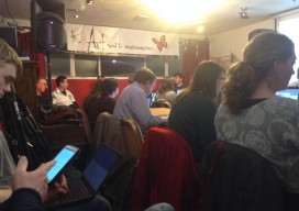
A year ago if you had said “Maptime” to me, I would have thought you were mad. I have now been to three “Maptime” events, and I want to share my experience, as you may be sitting there perplexed as to what you would gain from it. Maptime is increasing in popularity. Before Christmas [2014]...
QGIS v ArcGIS: the Rematch?
Thank you to all of you who commented and discussed my last QGIS v ArcGIS article. Many of you pointed at some of the perspective taken with the article, for example, there was mention that it wasn’t fair as ArcServer wasn’t tested or that the 3D tools weren’t compared. Yes, you are correct, it would...

Using Google Earth to Make 3D Models
No, I haven’t gone crazy; in fact quite the opposite. I was sent a visualisation of a wind farm from a company this week, and the back of my mind was niggling at me, telling me that I could do better at little or no cost. My first few attempts were involving QGIS2Threejs (QGIS 3D...
QGIS v ArcGIS
Okay, so I’m likely to get lynched, but before all the lovers/haters come out of the woodwork I’d like to remind everyone that these two systems are both great achievements. We are looking at two software systems that have changed the way we look at the world and the way we think about the world...
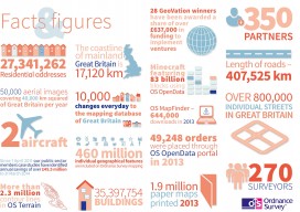
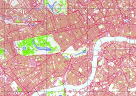
Ordnance Survey go GovCo
A new model for operation of The Ordnance Survey of the UK has been announced. This looks promising for the future of the customer and it is good to note the reference(s) to the use of the term “Open & free where possible”. It certainly looks like there are some exciting times ahead for the...
Open Source in the UK
Contrary to popular belief, it was neither the UK government nor Britain’s national mapping agency, Ordnance Survey, who started the UK open-source movement. Although open source was present and used in the UK before 2006, it was The Guardian newspaper that started a campaign called “Free Our Data,” which called for the raw data collected...