All posts by xyHt

xyHt Weekly News Recap: 07/22/2022
Bluesky’s Tree Map Helps Green Infrastructure Planning for Swansea Housing ICE Launches the ESG Geo-Analyzer for Property-Level Climate Risk and Demographic Data Astraius, Northrop Grumman Partner for First Satellite Launch from Prestwick Spaceport Digital Infrastructure Mapping Initiative Builds Momentum in California Betterview and Nearmap Join Forces to Enhance Catastrophe Response Time for Insurers Surveying &...
xyHt Weekly News Recap: 07/15/2022
MAPPS Summer Conference in Santa Ana Pueblo, NM Celebrating 40 Years of MAPPS Seabed 2030 Enters Partnership with Terradepth to Boost Crowdsourcing Initiatives Teren Kicks Off Nationwide LiDAR Content Library Program TPM Expands Its AEC Product Offerings with Leica Geosystems Laser Scanning Solutions Esri Offers Free Online Course on Geospatial Software for AEC Projects Constellation...

Surveyor’s Corner: Women in Surveying
The future for women in surveying is getting brighter all the time History tells us the journey for female surveyors began with Alice Fletcher in the late 1800s. Fletcher was a social scientist who tried to integrate Native Americans into the European culture spreading across America. After learning that Native Americans feared being banished to...
xyHt Weekly News Recap: 05/27/2022
New Energy Performance Data in XMAP Helps Tackle Climate Change Trimble Introduces High-Accuracy OEM GNSS Receiver Module Atmos Integrates Topcon Hardware to Create All-in-One Surveying Solution Fugro’s Lidar Geo-Data Supports OPW’s Irish Coastal Resilience Strategies Censys Technologies and American Aviation Regulator Complete BVLOS Emergency Response Project Applications Invited for URISA’s Vanguard Cabinet (URISA) Australian Company...
xyHt Weekly News Recap: 05/20/2022
The NSPS Foundation announces the 2022 Scholarships Major Geospatial Intelligence Asset Added to St. Louis’ New Innovation District Webinar: A Surveyor’s Perspective of Mobile Mapping Phase One Announces Next-Generation Aerial Solutions Enhanced with Near Infrared Capabilities Leica Geosystems Opens Nominations for Carl Pulfrich Award 2022 Program Set for Commercial UAV Expo 2022 URISA’s Vanguard Cabinet Announces 2022...
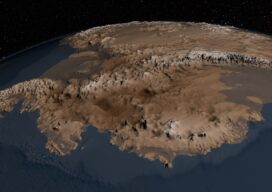
Maps As Art
Under Antarctica’s Great Ice Sheet The topography of the bedrock under the Antarctic Ice Sheet is critical to understanding the dynamic motion of the ice sheet, its thickness, and its influence on the surrounding ocean and global climate. In 2001, the British Antarctic Survey (BAS) released a map of the bed under the Antarctic Ice...