All posts by xyHt

xyHt Weekly News Recap: 05/13/2022
Geo Week 2023 is Already 80 Percent Sold Out XAG Promotes Drones in Vietnam to Boost Rice Farming While Cutting Fertilizer Use Bowman Expands Transportation Infrastructure Services with Acquisition New Leica Pegasus TRK Makes Mobile Mapping Smart, Autonomous and Easy RIEGL’s Laser Scanning Sensors on Display at GEO Business in London Teledyne FLIR Defense Introduces New Laser Target Designator...

Geospatial Services for Transportation & Utilities
GPI Geospatial, Inc. has been a premier provider of geospatial solutions for over 48 years. Our mission is to map the foundation for infrastructure, transportation, and land improvements that enhance the connectivity between people and communities. It’s our vision to be the most trusted provider of precision mapping, imagery, LiDAR, and surveying services within the...
xyHt Weekly News Recap: 05/06/2022
NSPS to Host Virtual Town Hall on Davis Bacon Act Regulations LiDAR for Drone 2022 Conference Set for June 13-14 in France World’s First Expandable Wing UAS Launches at AUVSI XPONENTIAL Army Corps of Engineers Picks Aero-Graphics for Geospatial Mapping and Surveying High precision mapping and automated workflows IDS GeoRadar launches cloud-based AI solution AiMaps...
Providing Comprehensive Geospatial Solutions
Sanborn is a full-service geospatial company that has been in continuous operation since 1866. Today, Sanborn is an innovator in the modern geospatial industry, delivering state-of-the-art mapping, visualization, and 3D solutions for customers worldwide. Sanborn offers comprehensive geographic information solutions to city, county, regional, state, and federal government agencies, private companies, and international clients. Our...
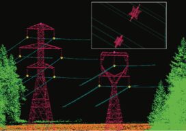
Empowering Utility Engineers to Make Informed Decisions
Aerial Services, Inc. (ASI) has been a leader in the geospatial industry for 55 years, offering turn-key solutions for lidar, orthoimagery, obliques, and geotagged 4k video supporting a multitude of applications, including above ground utilities. ASI provides rapid turnaround and high-quality mapping to assist utility engineers throughout the design, build, and inspection process. ASI’s utility...

xyHt Digital Magazine: May 2022
Like a good surveyor, xyHt’s May issue covers a lot of ground, bringing you stories about UAV/UAS, Lidar, Aerial Imagery and Mapping. As always, if you don’t have a subscription to our print edition, or if someone else in the office has snaffled your copy, don’t fret, here is the digital edition. Click here or on...