All posts by xyHt

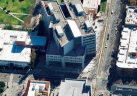
3D Scanning Technology: Renovating Boston City Hall
Ahead of its planned restoration works, Boston City Hall has been digitally re-imagined with 3D scanning technology, enabling architects to plan improvements for the iconic government building. Completed in 1968, the construction of Boston’s government building sought to boost the city’s economy, modernizing the urban center while reinvigorating and refreshing the neighborhood of Scollay Square. ...

xyHt Weekly News Recap: 04/22/2022
Biden Administration Plays Up Billions for Rural Infrastructure AGI Welcomes Business Development Specialist Angela Arriaga Trimble and Infotech Expand Collaboration to Improve Inspection Efficiencies for Infrastructure CHC Navigation Introduces Airborne Lidar Series Drone Nerds Displays Emerging Drone Technology Solutions at AUVSI XPONENTIAL NSPS Cosigns USGS Streamgages Letter PAR Government and BlackSky Deliver Near Real-Time Imagery Russia is...

Trust Your Position with Applanix
For nearly 30 years, Applanix, A Trimble company, has offered complete and customized mobile mapping solutions while championing the technology revolution that allows pinpoint positioning in any condition. Applanix is the standard for organizations that depend on accuracy and quality, and value experienced partners. Our turnkey and OEM GNSS-Inertial solutions are designed for pinpoint accuracy,...
Sanborn Relies on Vexcel Osprey Systems
Sanborn Relies on Vexcel Osprey Systems to Meet Growing Demands for Oblique Imagery In response to growing demand for oblique aerial imagery in the vegetation management, tax assessment, and 3D GIS markets, the Sanborn Map Company purchased two Vexcel UltraCam Osprey systems to better serve those applications. The Colorado Springs company replaced its existing oblique...
xyHt Weekly News Recap: 04/15/2022
Teledyne to Present Innovations for Unmanned Systems at AUVSI XPONENTIAL FARO Launches End-To-End 3D Digital Reality Capture & Collaboration Platform RTR Expands Drone Survey Capabilities to Include Lidar Trimble Opens Registration for Insight Tech Conference and Expo Skyfish and DroneLogbook Partner to Automate Drone Data Logging Anaconda and Esri Set Enterprise Standard for Python Across...
An Integrated Photogrammetry Solution
Carlson Software has innovated for the land development industry with software and hardware solutions built to work for the clients who depend on them every day. As a one-source solution, we provide CAD design software, field data collection, and laser measurement products for the surveying, civil engineering, GIS, and construction industries. Our flagship CAD program,...