All posts by Zach Pieper
New Heights: Aerial Photography, Aerial Data
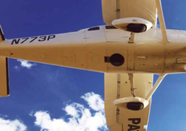
A Louisiana company upgrades its aerial photography camera hoping its business will soar Featured image: Looking up into the belly of a Cessna 206 airplane. The camera is looking down through the hole. Infrastructure like bridges (this one in Tampa, Florida), airports and oil and gas pipelines require regular aerial mapping for maintenance, installation and...
The Many Facets (and Faces) of Surveying
Surveyors have traditionally done a variety of essential and interesting work—and they continue to do so. We’ve asked surveyors from various work disciplines what inspires them. To get an idea of where we are going, it’s important to stop and take a look at where we have been. This rings especially true for those of...
Above the Mud
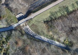
An orthographic image of the exposed spillway at Geode State Park in Iowa at 1″ ground sample distance. To improve water quality in a 500-acre state park, drones are key for surveying drained lakes and the surrounding watershed. Improving water quality is a key part of the Iowa Department of Natural Resources’ (DNR) mission. Planning...