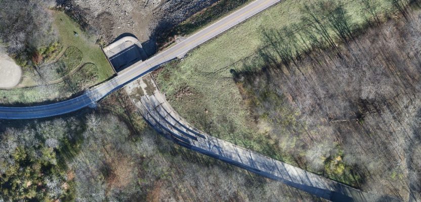
An orthographic image of the exposed spillway at Geode State Park in Iowa at 1″ ground sample distance.
To improve water quality in a 500-acre state park, drones are key for surveying drained lakes and the surrounding watershed.
Improving water quality is a key part of the Iowa Department of Natural Resources’ (DNR) mission. Planning and designing lake rehabilitation is an ongoing process requiring regular surveys over large and difficult-to-access areas. The Iowa DNR has identified drone technology as an important tool in surveying drained lakes and the surrounding watershed.
Geode State Park’s 174-acre lake in Danville, Iowa, was determined to have poor water quality and scheduled for renovation in the summer of 2018. Lake drawdown was initiated in October 2017, leaving a tight timeframe for survey, design, and bid letting at the end of November.
To accelerate the survey and lake bed design, the Iowa DNR turned to AeroView Services to provide topographic mapping and aerial imaging in a format compatible with Bentley Geopak software.
To complete design and determine silt volumes, the Iowa DNR needed an accurate survey of the lake bed immediately after drainage. Utilizing the latest drone data collection and processing technology, AeroView was able map the lake bed and surrounding area—more than 500 acres—in only two days.
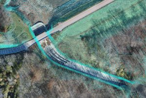
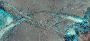
1′ interval contours derived from bare earth surface overlaid on the orthophoto.
Data Collection
The first step towards successful aerial data collection is understanding how the client will use the data. In this case, the DNR needed design and volume calculations for the lake bed. Required deliverables included a 3D surface, 1’ contours, and an orthographic photo, all in formats compatible with Geopak.
Once data requirements were determined, AeroView developed an optimized flight area and ground control plan. The 174-acre lake necessitated a flight area of over 500 acres for two purposes. We needed to capture the area surrounding the lake in the orthophoto and surface data and to optimize ground control distribution and placement. Proper distribution of ground control points and ease of access for the surveyor are an important part of the drone data-collection process.
The flight day started early with the placement of ground control targets on the points previously located by the DNR’s surveyor. AeroView’s flight crew located two suitable locations for takeoff/landing, providing line of site to the drone and ample area for fixed-wing landings.
Short fall days and high afternoon winds required two days of flights to complete data collection for the project. At the completion, ground control targets were retrieved and the data was handed over to AeroView’s technical team for processing.
Below: Orthophoto and contours show Old Indian Agency Trail, the oldest road in Iowa. Following a Native American Trail and completed in 1841, it once connected Burlington to the Sauk and Fox territory.
Processing
AeroView’s team of data experts performed multiple quality checks on the raw drone data and control before initiating photogrammetric processing. The team’s standard practice is to adjust multiple processing settings to deliver the results required by the client, and in this case the data was optimized to deliver the topographic data required by the DNR on the lakebed while maintaining good accuracy and photo quality on the outlying areas.
Once image processing was completed, AeroView’s experts used Carlson Software to classify vegetation and any man-made objects in the raw point cloud. From the classified point cloud they generated a 3D bare earth model of the entire project area.
With the bare earth model complete and checked for accuracy, AeroView’s team moved ahead with generating a contour map and a 3D model compatible with Bentley Geopak. In addition to the topographic data, AeroView generated orthophotos in full and reduced resolutions. The reduced resolution orthophoto gave the DNR a smaller file size for easier use during their design process.
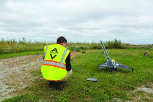
One of AeroView’s UAS pilots prepares to launch the Trimble UX5.
Multiple Uses
The Iowa DNR’s design team found the drone data to be indispensable in completing the final design and the bid documents and in letting the project. The Geopak-compatible 3D surface of the lake bottom provided more information than a bathymetric survey, allowing for detailed analysis and volumetric calculations of silt levels.
The high-resolution orthophoto displayed the current status of the lake bottom and surrounding areas, and it helped the design team identify the locations of existing fish habitat for removal and improvement. Even a long-submerged early county road, originally a native American trail, could be clearly identified in the drone data.
The Iowa DNR’s innovative team has expanded the utility of the 3D surface and orthophoto data outside the typical engineering workflow. The engineering team is using the high-resolution orthophoto to measure cracks and problem areas on the park roads for sealing and patching projects. They can accurately measure linear feet for crack sealing and even calculate square footage for pavement areas that require removal and replacement.
The orthophoto will be used in the bid documents to communicate the problem areas and required work. The engineering team has also found the orthophoto to be particularly useful in locating surface features and obstructions that were not captured during the normal ground survey.
The wildlife and forestry group are using the photos to evaluate plant health and ground cover, enhancing their effectiveness in the field. The park staff are planning to use the data to develop more accurate fishing maps, even identifying the exact location and depth of fish habitat.
The fisheries staff is using the drone data to develop a new process to measure sediment settling. Prior to draining the lake, it is mapped using a sounder, then after draining it is flown with a UAV. The process will be repeated in reverse when lake improvements are complete.
With the before/after 3D models in hand, the fisheries team will calculate how much settling occurs when the lake is drawn down and how the suspended sediment acts after it is dried. This data will be used to better understand how to manage lake maintenance and improve future designs.