Category Archives: Cartography

FLAIR Act Rides Omnibus to Federal Law
By Nicole Smith Legislation to create a current, accurate inventory or “cadastre” of Federal land owned by the Department of the Interior as well as the U.S. Forest Service, known as the Federal Land Asset Inventory Reform (FLAIR) Act, was enacted into law as part of the Omnibus appropriations bill passed by Congress and signed...

Space Mapping
A satellite set to launch in 2024 will scan the Earth’s surface every 12 days. What does that mean for geospatial professionals? During the recent South Florida GIS Summit, I had the pleasure of attending a presentation by the National Aeronautics and Space Administration (NASA) that blew my mind in terms of potential for the...

xyHt Digital Magazine: December 2022
xyHt’s December issue tackles a hodgepodge of subjects, from the what’s going on in the ocean to satellites mapping from space. As always, if you don’t have a subscription to our print edition, or if someone else in the office has snaffled your copy, don’t fret, here is the digital edition. Click here or on the cover...
Celebrating the 50th Anniversary of the Brooks Act
By John Palatiello On this day, October 27, in 1972, President Nixon signed into law legislation providing for qualifications based selection (QBS) of architecture, engineering, (A&E) and related services, including surveying and mapping. It was 50 years ago today the Brooks Act became law. At the time of its enactment, the Brooks Act was a...

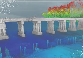
No Barrier Between Land and Water
Innovative tools and technology help hydrographic mapping deliver detailed data in previously inaccessible areas. Underwater mapping presents unique logistical challenges that are increasingly being met with technology used in creative ways, and by combining multiple types of data to develop a complete picture. From unmanned surface vessels (USV) to multi-beam sonar, advanced equipment yields accurate...
Teledyne Forms New Geospatial Company
Teledyne Optech and Teledyne CARIS have united to form the new Teledyne Geospatial, offering holistic solutions to seamlessly map land and sea through the integration of industry-leading lidar sensors and world-renowned software workflows. This collaboration empowers customers with a competitive edge in mapping and delivering data products inside of one complete workflow.Ease of collection and...