Category Archives: Construction/BIM

The Extended Entity of Autodesk
Has Autodesk become too large? Too diverse? Did the software get too complex? Or are those concerns missing the point? We’re far from the day when we can think of something we’d like and it simply materializes: there’s still a long path between ideation and realization. But, for more than three decades the path between...
Alasdair Begley
Alasdair Begley – Director – Saunders Havill Group – Australia Alasdair Begley views the design and development of commercial and public projects in a holistic manner and develops solutions to challenges— approaching each as integral parts of the design process rather than compartmentalized independent tasks. And with his bachelor’s degree in surveying from the Queensland University of...

Wizardly 3D
Above: This hologram of a church in Texas was built from a combination of airborne and terrestrial lidar scans. More than just illusions, hologram technology is booming. Every once in a while a new product or technology comes out that makes you do a double take and think, “Wait, what is that?” This happened to me...
True 3D Design
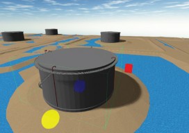
New geospatial software combines the appeal of games with the rigor of applications. It’s never been done before: applying the rigor and disciplines of civil engineering, mining engineering, hydrology, and even classic survey field-to-finish to game-like 3D design. Sure, CAD operators have had 3D viewing for years, which they use to review the results of...

Blending Realities
A 3D design and visualization tool with phenomenal potential in the AEC world is coming from a collaboration between Microsoft and Trimble. Imagine designing an object, in 3D and color, using only gaze, gestures, and voice (GGV) commands. Imagine designing an entire building the same way—or modifying an existing one. Imagine moving in a physical...
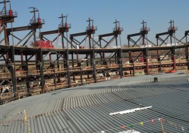
Raising the Roof
A survey company changes its tactics to monitor an auditorium roof before, during, and after its lift into place, using teamwork and true professionalism. American Surveying & Engineering, P.C. (with corporate headquarters in Chicago, Illinois) was approached by JP Cullen (a contractor with headquarters in Janesville, Wisconsin) with a challenging project: a particularly tricky auditorium...