
Category Archives: GNSS/Location Tech

Bruno Alexandre Krenski
23 Young Geospatial Professionals to Watch in 2023 – 15 of 23 Name: Bruno Alexandre KrenskiCompany: Top Terra & Measuring MastersCurrent position: Land SurveyorAge: 32 Education: Surveying Technician When my father was young, he got to know the profession and became a practical surveyor and a while bought his first total station and project software....

Ready, Re-set, Go
Post-pandemic digital transformation was on everyone’s mind at INTERGEO. With its mojo back, the world’s biggest geospatial trade event can once again offer the best geo-business innovations to get you all set for 2023. Germany’s annual INTERGEO event is the CES of the geospatial industry. If its Las Vegas counterpart is high on consumer electronics,...
UAS Processing as a Service
Speed, improved workflows, scalability, and analytical tools have boosted the popularity of such services—especially in these times of staffing challenges Creating deliverables from your UAS captured data, orthophotos, point clouds, photo meshes, and terrain models, can put a premium on the skills of your staff and processing resources. This is why an increasing number of...
Podium Position
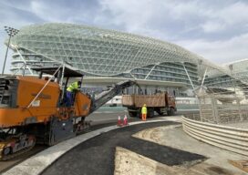
How the Yas Marina F1 circuit was resurfaced in just two weeks First opened in 2009, the Yas Marina Circuit in Abu Dhabi is now a key part of the Formula One (F1) season, often holding the final race for the World Constructors’ Championships and World Drivers’ Championships. The inaugural race in 2009 saw F1’s first...

Encoding Geography: Scale Up to Keep Up
America’s foremost community of professional geographers wants all students, especially women and minorities, to have a head start in geocomputational abilities. A revolution in teaching geography is in the offing. Demand for professionals with geospatial skills is on the rise. In 2019, expertise in geospatial technology was listed by Upwork, a global job website, as...
xyHt Digital Magazine: December 2022
xyHt’s December issue tackles a hodgepodge of subjects, from the what’s going on in the ocean to satellites mapping from space. As always, if you don’t have a subscription to our print edition, or if someone else in the office has snaffled your copy, don’t fret, here is the digital edition. Click here or on the cover...