
Post-pandemic digital transformation was on everyone’s mind at INTERGEO. With its mojo back, the world’s biggest geospatial trade event can once again offer the best geo-business innovations to get you all set for 2023.
Germany’s annual INTERGEO event is the CES of the geospatial industry. If its Las Vegas counterpart is high on consumer electronics, this European expo focuses on solutions for the international geospatial-IT community, displaying the newest tools on geodesy, geoinformation, and land management.

About 14,000 in-person visitors (plus 1,800 online) from 102 countries attended the INTERGEO expo held last October in Essen, Germany. Photography from the conference floor courtesy of INTERGEO.
For the last 28 years, the topics and products featured during the INTERGEO trade fair and conferences are a barometer of trends across the global geospatial sector. The main focus in 2022, for example, was on digital twins, a “mirroring technology” that is fast becoming the digital blueprint for managing our modern cities, buildings, and other built infrastructures.
Held last October in the bustling business city of Essen, Germany, the post-pandemic run of INTERGEO provided a welcome relief to geospatial professionals who are eager to forge fresh connections and strengthen old ones. Last year’s event attracted a respectable number of attendees with the lifting of travel restrictions by its host nation. Some 14,000 in-person visitors (plus 1,800 online) from 102 countries scanned the latest geo-tech offerings by 457 exhibitors, from the smallest start-ups to the biggest geospatial companies. Session halls and product booths drew crowds, and the excitement was palpable, as if everyone’s mood was to push the sector’s reset button after two years of disruption.
 “People seized the opportunity to cultivate their network, make new contacts, and experience solutions from the geospatial industry live,” said Dr. Hansjörg Kutterer, the event’s organizer and president of the Association for Geodesy, Geoinformation, and Land Management in Germany. “This year’s INTERGEO is proof that we are on the move into the post-pandemic era.”
And Kutterer is right. A remarkable uptick in activities in the architecture, engineering, and construction (AEC) sectors where geospatial services are very much in demand has been noted since 2021 by Deloitte, a business analyst company. And there are an increasing number of firms that now embrace digitization in the post-pandemic world. According to a polling of 500 AEC companies conducted by OpenAsset, a market watcher, more than 70 percent are willing to implement new digital technologies and to adapt to the new ways of doing business at home, in the office, and in the field.
The upheaval caused by COVID-19 has surely sped up the digital transformation of many sectors, including ours. Geospatial tools that are traditionally used in AEC projects were suddenly coveted during the pandemic. GIS maps tracked pandemic cases, drones flew to deliver essential medical supplies, and GNSS-based apps were used to improve contact tracing. The upshot is very clear: digital transformation with geoinformation is key to achieving post-pandemic success.
One of the talking points during the conference sessions, for instance, was how social distancing and lockdowns disrupted the way we collected geospatial data. Many of the speakers and participants shared how they managed, despite the enforced restrictions, to maintain geospatial data efficiency, especially at the point of capture. This was made possible by decades of work perfecting how geospatial data is remotely collected (think of satellite imagery), while at the same time keeping the integrity of data at scale (think of lidar).
Some of these trailblazing tools were on display at INTERGEO. An overflowing abundance of remote data capture options sprawled over 110,000 square meters of exhibition space, from low-Earth orbit cube satellites to UAVs, GNSS receivers to laser scanners, as well as apps for mobile phones, software, and cloud platforms.
While one can easily be overwhelmed by the depth and breadth of the geospatial products hitting the market this year, it is always helpful to look beyond slogans at a time when everyone seems to be pinning the label “game changer” to anything that beeps. It’s good to start your search for innovative geospatial products that follow this digital era’s trifecta of speed, scale, and granularity.
In brief, here’s a rundown of innovations at INTERGEO that will push forward your geo-business in 2023 and beyond:
Speedier workflows in a compact package
Decades of innovation in computer processing has allowed us not only to have tools that can perform tasks more quickly, but also to pack more data in smaller (and even smaller) devices. However, this does not always translate to faster workflows, especially in data-intensive applications like terrestrial scanning.
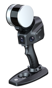
Here is where REIGL hits the right spot with the release of their VZ-600i, the Austrian company’s latest terrestrial laser scanner (TLS) that they fittingly debuted at INTERGEO.

REIGL debuted the VZ-600i, the Austrian company’s latest terrestrial laser scanner, at their booth in INTERGEO.
With its one-touch button operation, simultaneous scan and image data acquisition, and the capability to automatically produce detailed PDF-reports in a flash, the VZ-600i ensures speedier workflows and greater productivity. Faster than other TLS gears, it completes a single scan with six-millimeter point resolution in less than 30 seconds. Data transfer rates are also quicker at 500 megabytes per second, perfect to create point cloud models within moments of capture.
We all want to get the job done fast, but no one is willing to drag around a heavy equipment, REIGL designed the VZ-600i to be as lightweight as possible. This TLS weighs six kilograms (13 pounds), the lightest in its class. It is the perfect gear that can be transported easily every day, especially if you work in projects that require you to move constantly. First time viewers at INTERGEO also noted its ability to take photos without the need for a spare camera, an extra weight-saving bonus in the field.
Your back will not only thank you, but so will your customers because the VZ-600i is heavy on other features. It has a 3D accuracy of three mm and a point noise of less than one mm, useful to precisely capture the smoothness and edges of built structures. And with a peak pulse repetition rate of 2.2 MHz, its measurement distance can range from 0.5 to 200 meters, ideal to gauge any space from the smallest tunnels to the widest roads.
The VZ-600i is also future-ready as it comes with drivers for robotic operations and mobile mapping, plus it works with Python-based apps. This TLS is the right match for the forward-thinking geospatial professional who wants to create good quality scans fast.
Granular-level precision for better 3D models
The XH120 GO from STONEX is the right SLAM tool to tease out the required granularity in 3D models.
While speed and scalability are important, granularity in geospatial data should not be overlooked. The advent of better cameras and other higher-resolution imaging sensors have made granularity an essential geospatial factor in 3D mapping nowadays, especially when levels of detail need to be specified at the on-set of any project. But why is granularity important?
When an actual built object, say a wall, is scanned then mapped in 3D models, we need to specify that each pixel comprising that wall has a well-defined crisp boundary to make it distinct from all other built objects. Floors should not be confused with ceilings nor doors, for example. If this is not done, all we are left with are low-resolution and coarse-grained 3D models that are not suitable for creating BIM models and digital twins.
SLAM devices, such as the XH120 GO from STONEX, are the right tool to tease out the required granularity in 3D models. The millimeter-level accuracy of the XH120 GO casts 320,000 points per second, and with its 360-degree rotating head, it generates 360-degree by 270-degree point cloud coverage. Computer vision algorithms then distinguish each pixel, grouping them as recognizable real-world features.
Short for simultaneous localization and mapping, SLAMs are unlike terrestrial scanners because they do not sit on tripods. They are designed to be carried by hand so that work can proceed on foot, even without light and GPS. In the case of the XH120 GO, mapping on-the-go is possible in GPS-denied environments such as tunnel interiors and buildings under construction. Weighing just below two kilograms, this device makes  scanning en route like a walk in a park compared to heavier TLS apparatuses.
As 3D point clouds are created by moving around a particular area, internal sensors within the device track positional information, allowing each point to be later placed correctly during the data processing stage. The XH120 GO has two dedicated pre- and post-processing softwares to fulfill just that: the Android-based GOapp that can display point cloud in real-time, and the Windows-based Gopost for optimized processing and creation of panoramic images.
Scalable accuracy to match various needs
Scalability is another innovation that one should look for in new geospatial gadgets. Simply put, it is the ability of computing devices to increase or decrease their performance, as needed. In mapping projects, for example, scalable solutions can make it possible for surveyors and GIS professionals to choose their desired positioning accuracy to match their operational needs and their customers’ budgetary limitations.

The Trimble TDC650 is scalable and nimble data collector that is perfect for GIS professionals.
Yet not many Global Navigation Satellite System (GNSS) positioning devices can offer this type of scalability straight out of the box. So, the release of the Trimble TDC650 handheld is a welcome treat for those of us who collect location information from scratch and need a handy tool to carry along. Users can choose the handheld’s positioning accuracy (from 1-100 cm) without the need for an external antenna or a pole, a plus for working in far-flung and rugged conditions.
Its IP67 rating also makes the device dust proof as well as water resistant (up to 30 minutes in one-meter-deep water). And with a six-inch screen size, it is the best pocket-sized data collector to bring along in the field. It seems smart on the part of Trimble to create a scalable and nimble data collector like the TDC650 as the geospatial industry has been inching toward useful mobile solutions in the field for years.
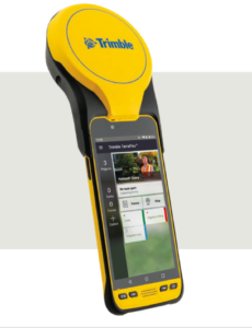 Furthermore, as an Android-based mobile phone with GNSS capabilities, the TDC650 can also perform all the things that a modern smartphone is expected to do because it can run core Google applications and services. Do you need to check in with your client (or supervisor) while you are already out working on site?
With the same device, you can call them or connect to the internet with its high speed 4G LTE cellular data connectivity. You can even use it with Android apps for a fully customized data collection device. Here’s one wish though: let’s hope that the TDC650’s future iteration will be 5G-ready because that will surely provide even higher data speeds and lower latency.
Award-winning innovations
INTERGEO is not only a trade fair showcasing products. It also recognizes the work of companies and individuals for their remarkable geospatial innovations. The Wichmann Innovations Award went to Leica’s AP20 AutoPole for its groundbreaking solution that allows measurements even when the pole is tilted. Surveyors will also appreciate its capability to automatically adjust pole height readings as well as to identify targets on the fly, locking on to them until the job is completed.
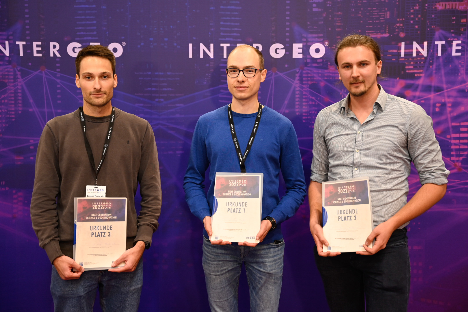
Winners of the Intergeo Next Generation Science and Geoinnovation Award. Steffen Becker (center) from the Karlsruhe Institute of Technology won the top prize for his research on monitoring vehicular traffic using drones.
For the individual awards, INTERGEO focused on people whose projects will certainly inspire other geospatial workers. Kyriaki Mouzakidou, a PhD student from the Federal Institute of Technology in Lausanne, Switzerland, won the Young Surveyors Contest for her work on improving the accuracy of point clouds by fusing lidar and camera sensors with raw GNSS and inertial data. Her ingenious solution aims to create more accurate point-clouds from laser scanning projects.
Another noteworthy effort, this time on the use of satellite imagery and in situ sensors to monitor large-scale flooding in Germany, was awarded the Geodesy Prize. It went to the team of Arne de Wall for their SenSituMon project, which leverages automatic recorders with radar and multispectral data from Sentinel satellites.
Two of the most important INTERGEO awards went to projects that involved the use of drones and digital twins. The “Next Generation Science and Geoinnovation Award” was given to Steffen Becker from the Karlsruhe Institute of Technology for his research on monitoring vehicular traffic with UAVs. While the “DVW Future Prize” was awarded to the German cities of Hamburg, Leipzig, and Munich for their “Connected Urban Twins.” According to the INTERGEO, the project is an example of how a smart-city initiative can truly work, providing a collaborative data platform for their citizens and city managers.
With all the latest gadgets and good news coming out of INTERGEO, it truly feels like the geospatial industry is on its way to a fresh re-start. For the resilient and resourceful geospatial professional, we hope that the past year has provided positive opportunities despite its challenges. And for those who are wondering what the future of geospatial looks like, then the next INTERGEO in Berlin merits a visit. Here’s wishing that 2023 will be full of personal and geospatial accomplishments for everyone.